- Remarkable discoveries in an Amazon cave rewrote human history, but it remains largely unknown as farmers advance closely.
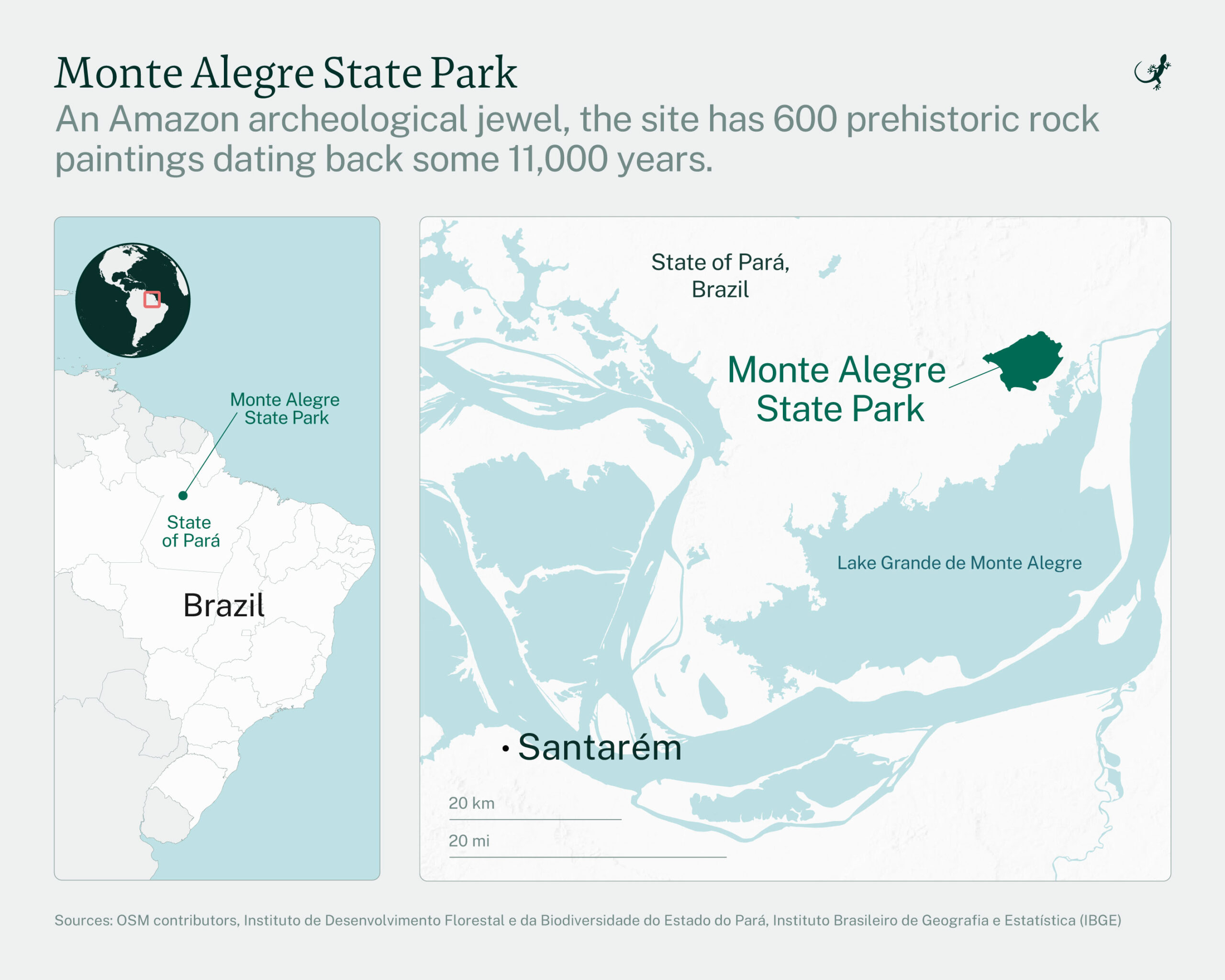
- Boasting hundreds of ancient rock paintings, Monte Alegre State Park (PEMA) in northern Brazil is a natural and cultural marvel, yet it barely attracts 4,000 visitors a year.
- Deforestation is accelerating around Monte Alegre, with 11,000 hectares (27,180 acres) of forest lost in 2024, largely to soy farming.
- A new report revealed a worrying pattern: By 2023, more than half of Brazil’s archaeological sites were located close to recent human activity, largely due to the expansion of farming.
MONTE ALEGRE, Brazil — Despite its name, all is not well in Monte Alegre, or “Happy Mountain.” Situated on the north bank of the Amazon River, some 120 kilometers (74.5 miles) from Santarém, a town with some 50,000 inhabitants, Monte Alegre guards one of Brazil’s best-kept secrets.
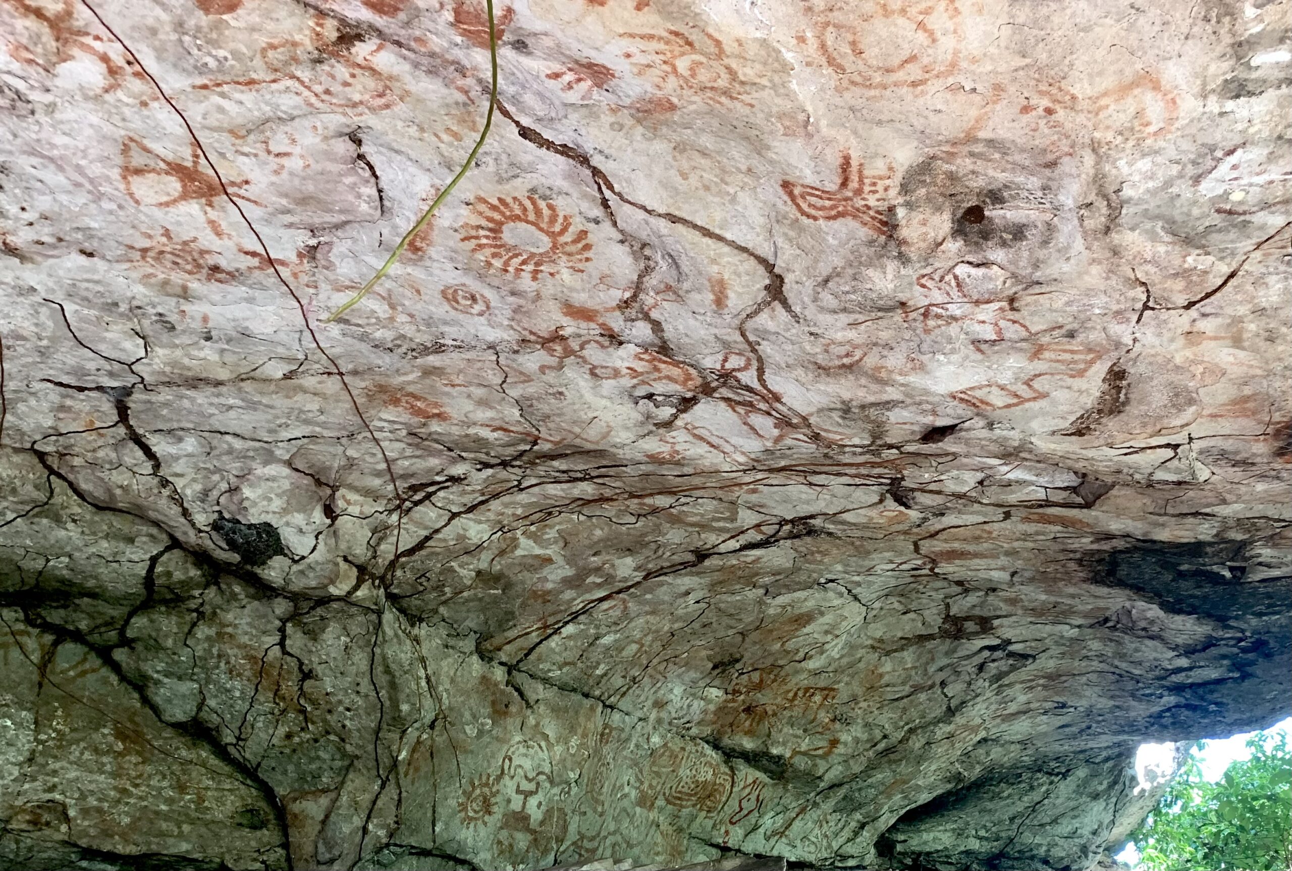
Founded as a conservation area in 2001, the Monte Alegre State Park (PEMA in Portuguese), protects a forested complex of canyons, valleys and caves, home to some 600 prehistoric rock paintings dating back some 11,000 years.
Measuring 3,678 hectares (9,090 acres), PEMA’s cultural value and natural beauty would be a top attraction anywhere in the world. In 2002, it was chosen as one of 25 global heritage sites by World Monuments Watch (WMW), a flagship advocacy program of the nonprofit World Monuments Fund. Yet, the park struggles to attract visitors.
“It’s one of our biggest challenges,” said PEMA’s general manager Jorge Braga. “We have some 4,000 visitors annually. That’s not a lot.”
Sitting at the Monte Alegre main square, Braga blamed a combination of visibility and accessibility. He estimated that only one in ten people living in the region knew about the park’s value. Among Brazilians living elsewhere and foreign visitors, the ratio will be way lower.
It’s hardly the only problem the park is facing. While PEMA offers the highest possible level of environmental protection, the surrounding area is increasingly falling prey to deforestation.
Pará state in northern Brazil long had one of the highest deforestation ratios in the country, yet until recently the northern part of the state, protected by the mighty Amazon River, was an exception. No more, though.
The 50-km (31-mile) drive from Santana, where the Santarém ferry docks twice a day, to Monte Alegre leads through a rolling landscape with plenty of forest. However, there are numerous meadows for cattle farming, while several enormous plots of land have been stripped of all vegetation.
According to a local activist who preferred not to be named, one family from Mato Grosso is buying up land in the region, already owning some 3,000 hectares (7,413 acres), which they plant with soy twice a year.
Braga confirmed that soy had entered the Monte Alegre region about two years ago. In addition to the deforestation, he said, soy was a danger to people’s health due to the copious amounts of toxins that are used to grow the crop.
“We’ve started a movement to make people aware,” Braga said. “But it’s dangerous. Soy farmers first tried to enter the region in 2001. I was one of the people opposing them. As a result, I received death threats and lived under police protection for two years.”
According to Global Forest Watch (GFW), between 2001 and 2024, Pará witnessed the highest deforestation rate (18.6 million hectares, or 46 million acres) in all of Brazil, followed by Mato Grosso (14.2 million hectares, or 35 million acres) and Maranhão (6.6 million hectares, or 16.3 million acres). Representing 54% of all deforestation in the country, trees predominantly made way for cattle farming and cash crops such as corn, sugarcane and soy.
Within Pará, according to GFW, Monte Alegre only lost 66,600 hectares (164,500 acres) of humid primary forest between 2002 and 2024. But deforestation seems to be accelerating, as in 2024 alone Monte Alegre lost 11,000 hectares (27,200 acres) of natural forest.
Especially close to the Amazon River, Monte Alegre increasingly looks pink on GFW’s digital map — the color indicating deforestation. Further north, the dominant color remains green, thanks mainly to the Grão-Pará Ecological Station, with 4,245,819 hectares (10,491,650 acres), one of the world’s largest fully protected tropical forest units.
Monte Alegre is not alone. A new report by the Brazilian collaborative monitoring initiative MapBiomas revealed a significant increase in human intervention around archaeological sites in Brazil from 1985 to 2023. By 2023, over half of these sites were located near recent human activities in all Brazilian biomes, presenting challenges for preservation. Farming now constitutes the largest share of land use around archaeological sites, according to MapBiomas.
Monte Alegre and Alfred Wallace
Despite not drawing crowds today, Monte Alegre had already sparked the curiosity of British naturalist Alfred Russel Wallace, who visited it in 1849 as part of his four-year exploration of the Amazon Rainforest. The one thing Wallace wanted to see on his trip was the “Indian-picture writings” he had heard so much about.
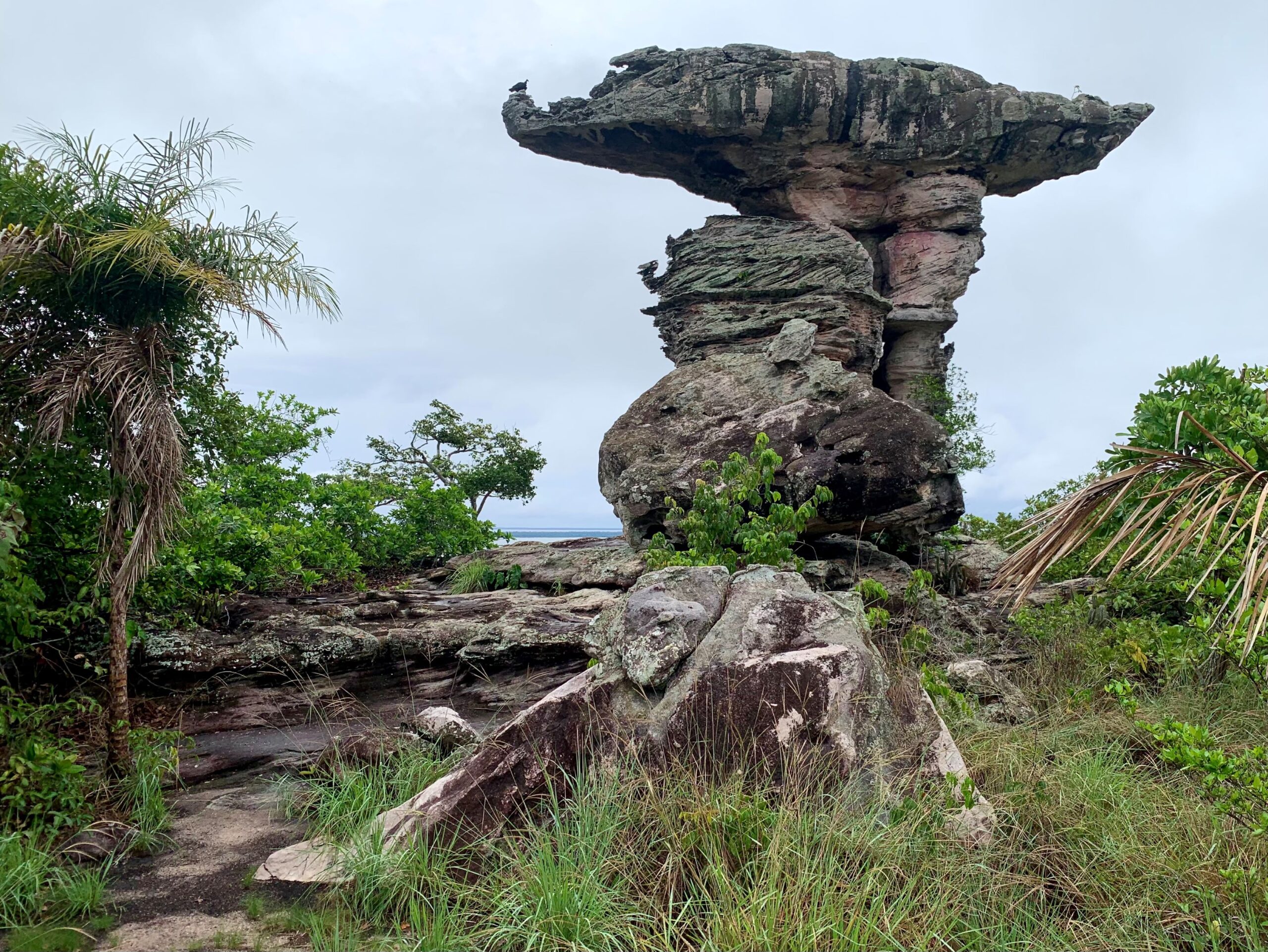
Known as the co-father of evolution theory, Wallace traveled by boat and on horseback. Passing the landmark Pedra do Pilão, a canoe-like rock delicately balancing on top of a large boulder, he spotted numerous red-painted images of animals, human-like figures and geometrical patterns before reaching an image of several strikingly large figures.
“They consisted principally of large concentric circles called the sun and the moon by the natives,” he wrote in his book Travels on the Amazon.
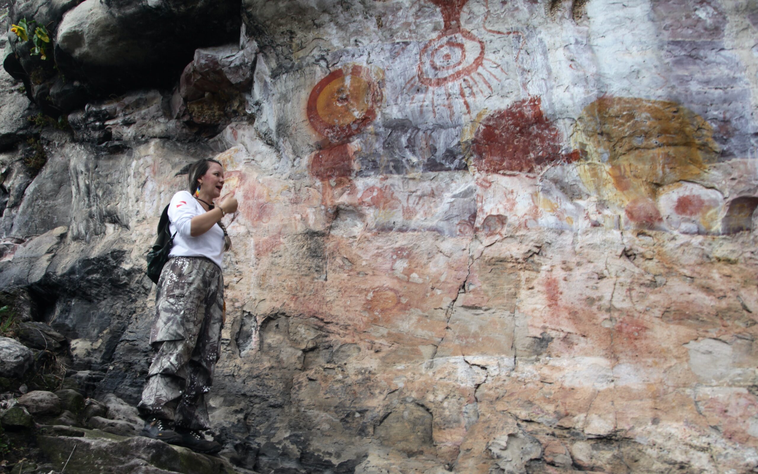
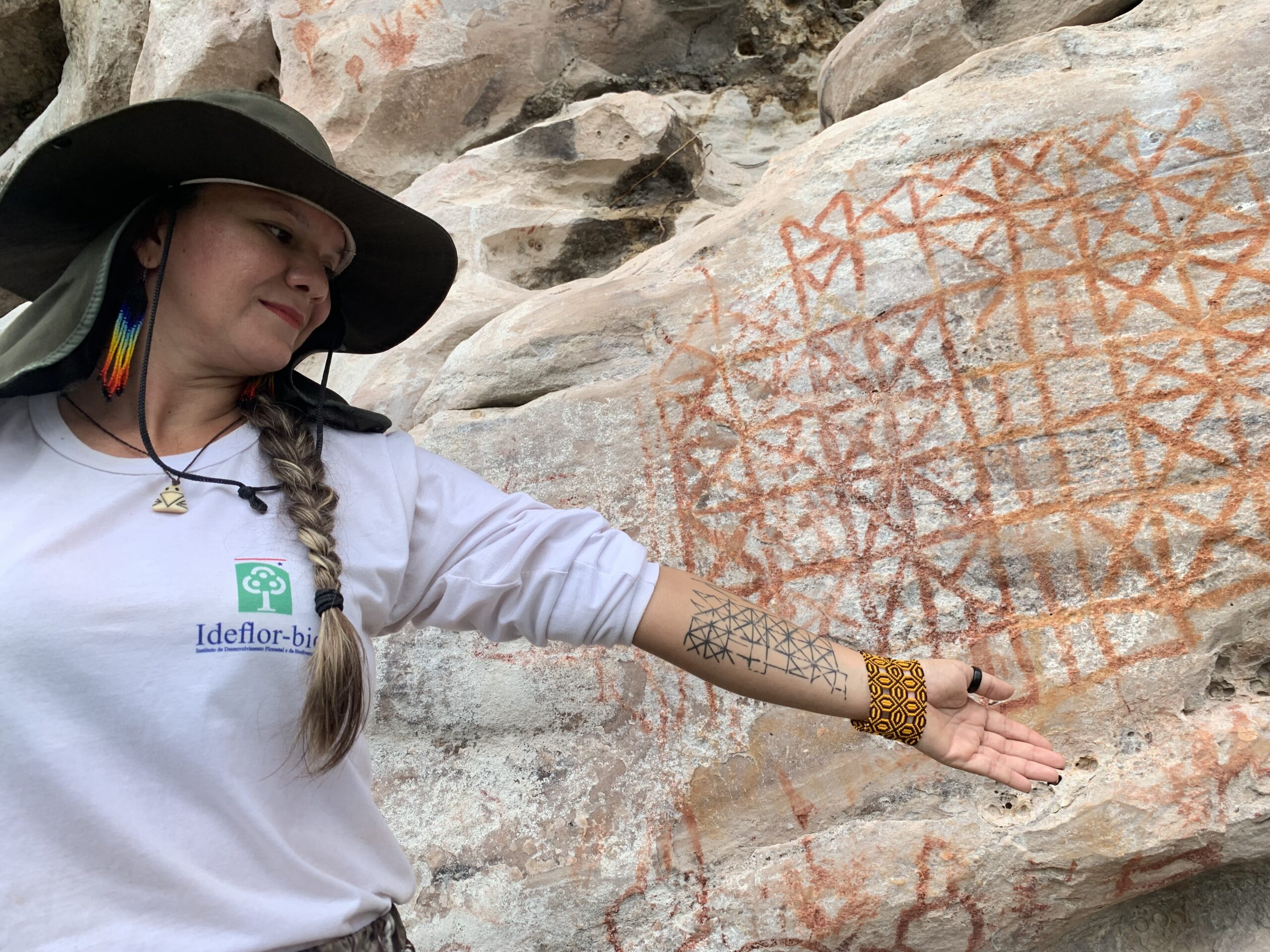
Wallace’s description of a seemingly perfect yellow-in-red circle and a hanging figure with a radiant head refers to the Mona Lisa of some 600 prehistoric rock paintings found in PEMA. Unlike Wallace, today’s visitors can reach the park’s centerpiece by climbing a rock-cut staircase.
“The yellow and red circle could represent an eclipse, while the rays may be the sun or lightning,” park guide Luana Wanessa Assunção told Mongabay. “To me, looking at these ancient drawings is like looking at contemporary art. It is a game of interpretation. Where one person sees a fish, another may see a bird.”
One difference with contemporary art is that the latter is generally admired indoors, in a museum or gallery, while PEMA offers a wonderful and quite unique natural setting.
The park’s rugged relief is known as the Monte Alegre Dome. It is the result of tectonic activity millions of years ago. Due to the mix of rocky outcrops and sandy valley floors, the park’s flora is more savanna-like than rainforest. One could say that the Monte Alegre Dome is an island of Cerrado within an ocean of Amazon.
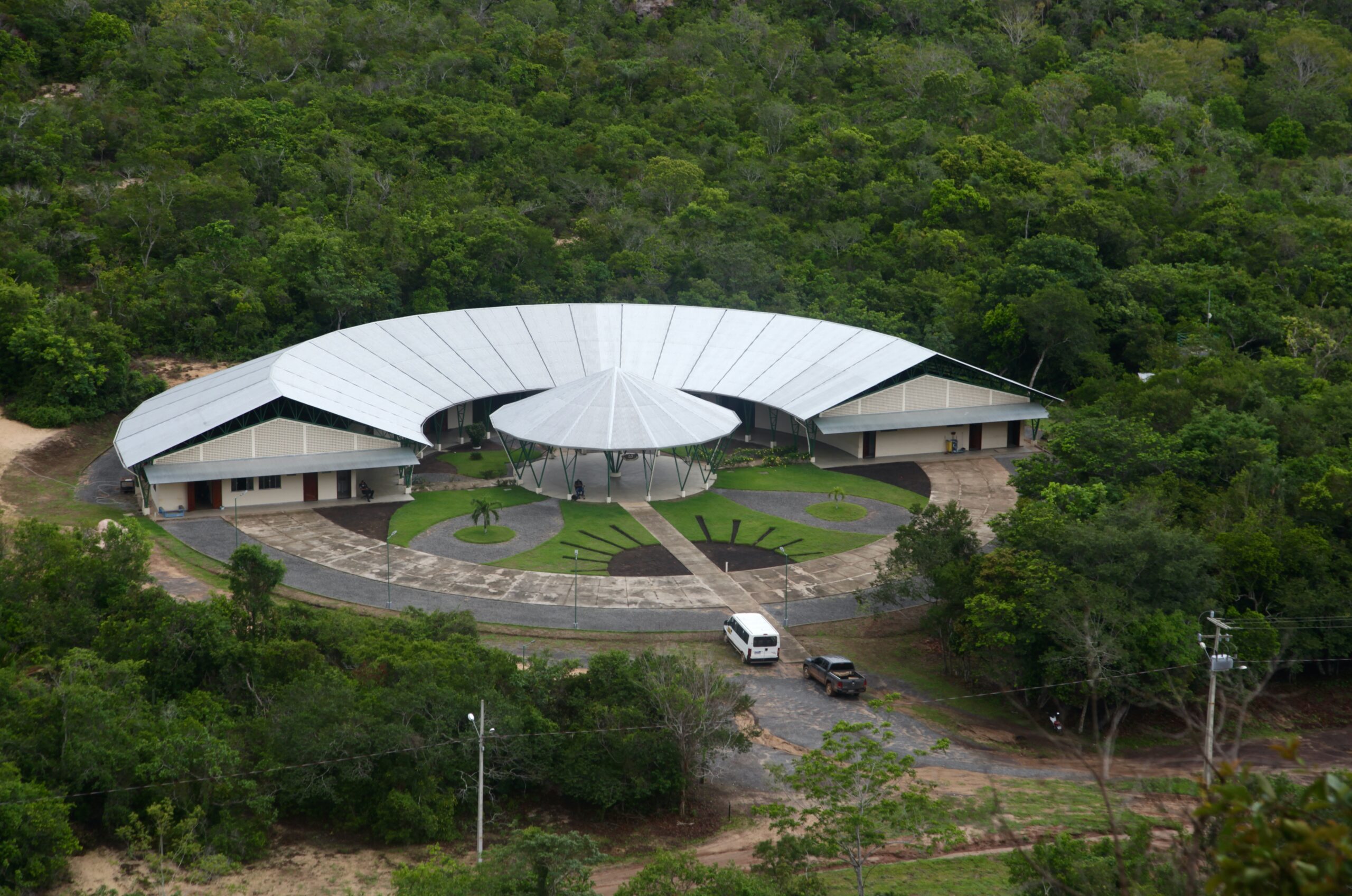
At the foot of the so-called Serra da Lua, or “Moon Mountain,” where the famous image of the sun and moon are found, lies the enormous crescent-shaped PEMA visitor center against the backdrop of another forested hill.
“That hill is closed to the public, as it’s very hard to climb,” said Assunção. “A pity, as it’s the only place where you’ll find an image of a moving person. All other paintings in the park show static figures.”
Writing history twice
Wallace was a whole lot less impressed by his visit to Monte Alegre’s largest cave. Situated further inside PEMA, the cave still has the “smooth sandy floor” Wallace described and “the openings into other chambers,” which he could not explore, as he had forgotten to take candles.
Had he taken them, he would arguably have scared the dozens of bats that have made the arched cave their home, which is what happened to us when we lit our mobile phones.
“There was nothing at all remarkable about the cave,” Wallace wrote in his 1853 travelogue. “The vegetation around it was by no means luxuriant or beautiful. In fact, many of our caves in the limestone district [in Britain] are in every way more picturesque and interesting.”
When I finally set eyes on the cave after a long walk through the forest, I was overcome by a sense of awe. A sensation only enhanced by the baritone welcoming, or warning, of a howler monkey, which for a split second seemed to silence the entire forest.
Had Wallace known what we know today, would he have had a more flattering opinion of the cave? History was written twice in what is today known as the Caverna da Pedra Pintada, or the “Painted Rock Cave.”
First and foremost, by the prehistoric people who sought shelter here and made their mark by painting the cave’s walls. Secondly, by the 20th century scientists who followed in Wallace’s footsteps and excavated the cave floor.
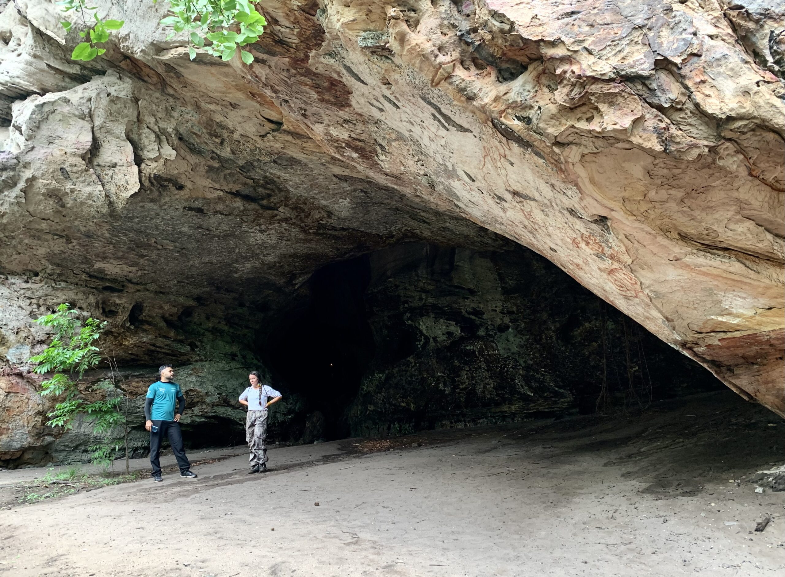
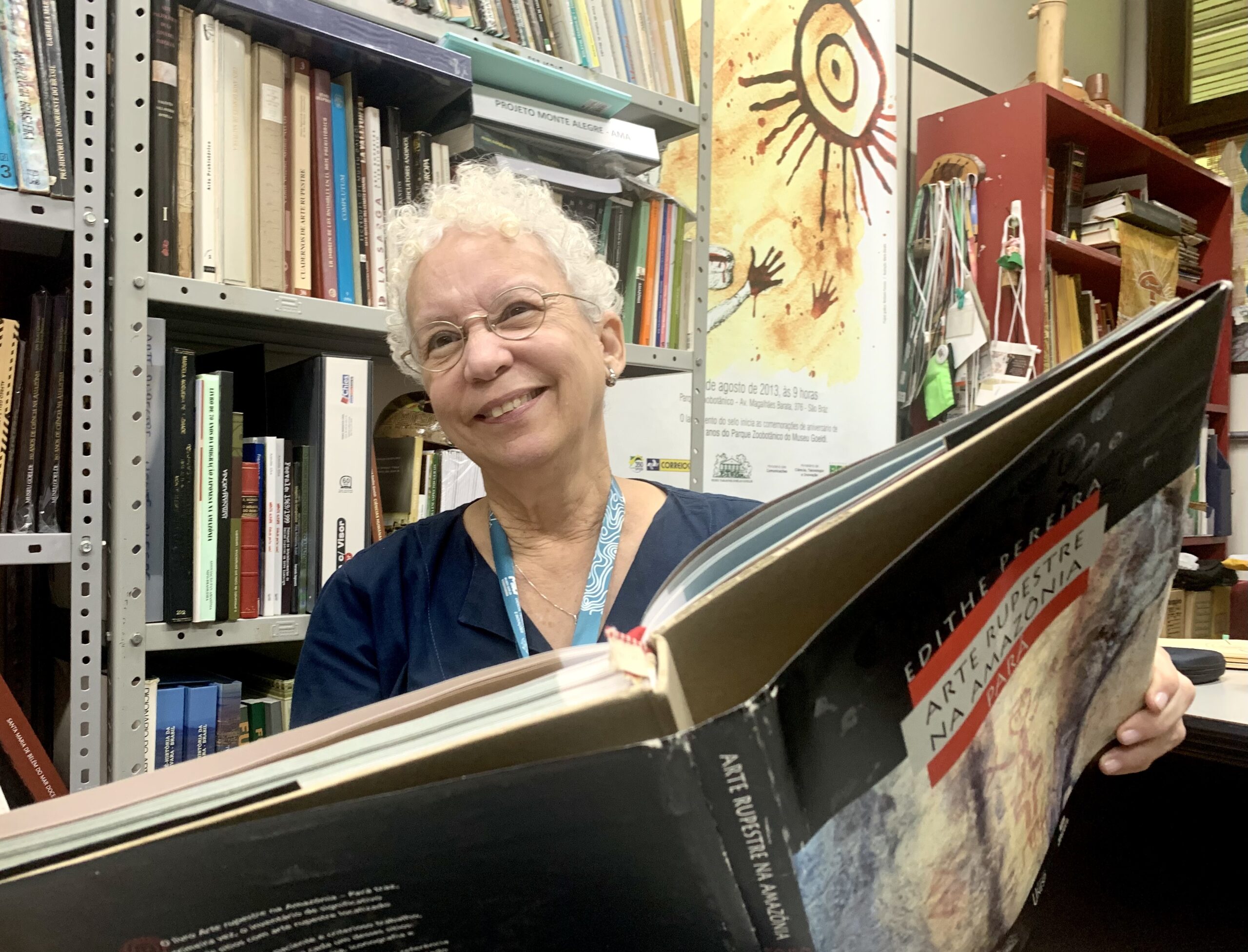
“Here’s where the American archaeologist Anna Roosevelt dug,” said Assunção, pointing to the right side of the cave. “And on the other side the Brazilian archeologist Edithe Pereira worked.”
In the early 1990s, Roosevelt was the first to excavate part of the enormous cave and radiocarbon-date her finds. What she found was beyond her wildest dreams.
The remains of stone tools, charcoal and food, mixed with materials used to paint, dated back some 11,200 years. Pereira’s findings confirmed Roosevelt’s dating and even turned back the clock by a few hundred years more. In doing so, Roosevelt and Pereira turned history on its head.
Until then, the dominant theory had been that the Amazon River Basin had been sparsely populated for some 2,000 years or so. Moreover, it was standard theory that the first humans only set foot on the American continent at the end of the last Ice Age.
Having crossed the Bering Street into Alaska around 11,000 years ago, so it was thought, they then slowly worked their way down across the Great Plains towards the Equator, the Andes, the Amazon and beyond.
But how could that be the case if, by then, people were already hunting, gathering and painting cave walls in Monte Alegre at the heart of the Amazon?
And, those early inhabitants did not just paint seemingly crude images of animals and people, but also a geometrical figure of boxes and crosses that looks like a giant version of the game of tic-tac-toe. Known as the Painel do Pilão, it is thought to be the first-ever solar calendar of the Americas.
This new understanding of human occupation in the Americas lays the groundwork for a new effort to protect the Amazon and other biomes for their cultural value and not just their nature. Led by Brazilian archaeologist Eduardo Neves, scientists are lobbying to register archaeological sites as national monuments, which would confer an additional layer of legal protection to parts of the rainforest.
By officially recognizing these sites, such as the numerous earthen mounds known as geoglyphs, the aim is to keep the forest intact and allow local communities to continue living there. Neves sees forests much like Egyptian or Mexican pyramids, highlighting their profound cultural significance that merits protection.
Treasure management
While PEMA would be a top attraction almost anywhere in the world, the sad reality is that most people in the region are not aware of what the park has to offer and very few foreigners traveling by boat between Belém and Manaus take the trouble of making a stopover at Monte Alegre.
“PEMA has everything to be as successful as the Serra da Capivara National Park,” said Pereira at her office at the Emilio Goeldi Museum in Belém, referring to another archaeological jewel in Brazil. “But it isn’t. There are problems with the organization, with promotion, with education.”
Declared a UNESCO World Heritage Site in 1991, the Serra da Capivara National Park in the northern state of Piauí is home to thousands of prehistoric rock paintings, while archeologists also found stone tools dating back 22,000 years — further rattling the cage of common theory. It attracts more than 20,000 visitors a year.
“When PEMA was created, the Instituto do Patrimônio Histórico e Artístico Nacional [Brazil’s historical heritage agency] asked a group of researchers, including me, to formulate a plan to help ‘socialize’ the park,” Pereira said. “And we did. But nothing was done with it,” she added angrily.
“From the start, the aim was to develop social and educational activities with the local community, to make the park a part of the community, to create a sense of ‘ownership’ and thus enhance protection,” she continued. “But there has long been a lack of political will to do anything.”
PEMA is run by the Pará State Institute for Forestry and Biodiversity Development (IdeflorBio/PA). Created in 2007, the organization is primarily tasked with promoting “the sustainable development of the different forest segments of the State of Pará” as well as “manage biodiversity.”
“Having done my PhD, I wanted to reach a wider audience,” said Pereira, putting a pile of books and booklets on the table. “I worked on an illustrated book on rock art, on children’s books, a graphic novel, a CD, I wrote articles for magazines, produced educational material for expositions and schools. And the end result was always the same. Either it wasn’t used or it was used the wrong way.” At one point, art teachers in the region indicated they wanted a booklet on local history, so Pereira and some colleagues, with financial support from the Pará state government, embarked on an “archaeology for schools” project. The end result was distributed for free in schools across the region.
“In the end, one teacher used it,” Pereira said. “Look, I’ve tried. But I’m tired. I’m very tired.”
More rock art
PEMA paintings are arguably the most famous, perhaps the oldest, yet by no means the only rock art found in the state of Pará. Pereira showed a map, which is dotted with locations of rock paintings and rock inscriptions.
“As early as the 16th century, Jesuit priests noted the presence of rock inscriptions along Pará’s rivers,” she said. “But most of the state has not been mapped yet.”
Having worked in the region for more than 30 years, Pereira has identified some 60 more rock paintings in the Monte Alegre region, about a dozen of which are found in an Indiana Jones-like landscape of boulders and lush vegetation some 30 km (18.6 mi) north of PEMA.
The land in question happened to be for sale. A friend of Pereira decided to buy the three hectares (7.4 acres) of land for 40,000 reais (about $7,000) in order to protect it. Further research will have to determine the who, what and when of the images on display.
If that’s not done soon, the region could succumb to the increasing threat of fire to clear the land of vegetation, cattle farming and a little oil-rich bean rapidly marching north: soy.
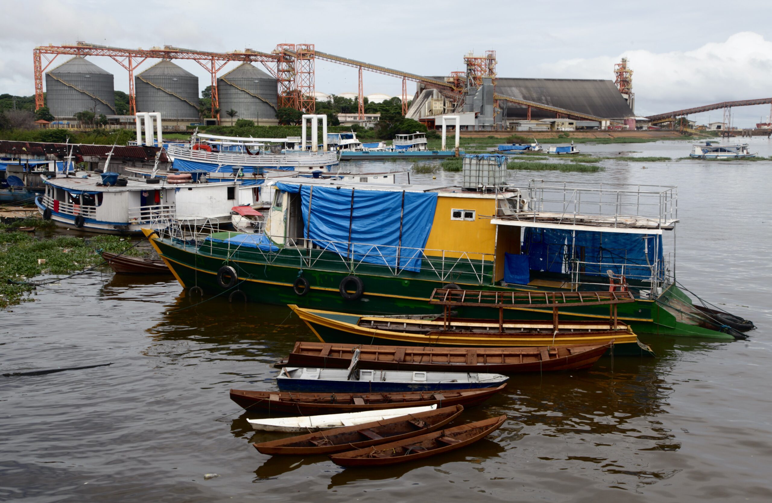
The fact that the latter has by now reached the northern bank of the Amazon River cannot be seen separately from commodity trading giant Cargill inaugurating grain terminals in Santarém in 2003 and, further south along the Tapajós River, in Itaituba in 2017.
As the northwest of Pará was turned into a logistics hub, the region known as the Santárem Plain grew into one of the 10 biggest soy-producing regions within the state.
While local communities in both Santarém and Itaituba allege the American multinational did not comply with environmental rules and licensing regulations, villagers’ lives on the Santarém Plain are increasingly being poisoned by pesticides.
Cargill is currently in the process of constructing a 700-million-reais (143-million-dollar) terminal at Xingu Island near Belém, a development bitterly opposed by local residents. Brazilian prosecutors are investigating alleged irregularities in transactions between Cargill and a local partner acquiring the land.
In December 2024, the Mato Grosso chapter of Aprosoja, the powerful soy producers’ association, petitioned national authorities to repeal the Amazon Soy Moratorium. The soy lobby group argues that the moratorium, which bans the signatory parties from purchasing soy on land deforested in the Amazon after July 31, 2008, creates a “purchasing cartel” imposing restrictions violating Brazilian law and costs the state 20 billion reais ($3.5 billion) in annual losses.
Following his visit to Monte Alegre in 1849, Wallace continued his journey westward, eventually sailing up the Rio Negro, nearly reaching the Brazilian border with Venezuela.
Having crossed the Atlantic from Britain, he remained in the rainforest for four years to study flora and fauna, collecting thousands of species along the way.
He would, no doubt, turn in his grave knowing that some people today see no problem in destroying the Amazon’s overwhelming diversity to replace it with a cash-crop monoculture, threatening the “Indian-picture writings” he had so desperately longed to see.
CORRECTION: (8/11/2025): Monte Alegre State Park (PEMA) was incorrectly identified as PETA through the article. The post has been correct.
New conservation model calls for protecting Amazon for its archaeological riches
FEEDBACK: Use this form to send a message to the author of this post. If you want to post a public comment, you can do that at the bottom of the page.