

Scientists have described a species of tiger cat that was previously unknown to science. From Bolivia’s Yungas cloud forests, it is the first discovery of a living novel cat species in more than 100 years.
The tilcayo (Leopardus tilcayo) takes its species name from the name locals already had for it. Paola Nogales-Ascarrunz, a National Geographic explorer who discovered the species and co-author of the Current Biology paper that describes it, said the name honors traditional knowledge in the region.
The tilcayo is smaller than a domestic cat at 1.4 kilograms (3 pounds). It has rounded ears, a slender body and a coat with large spots.
“I have the honor of naming a cat, and that’s a really big thing,” Nogales-Ascarrunz, who is also a researcher at the Universidad Mayor de San Andrés in La Paz, Bolivia, told Mongabay by phone.

For decades, researchers lumped small spotted cats across South America under a single species name: Leopardus tigrinus or tiger cat. However, evidence had been mounting for years that the group might contain several species.
In the article published on Sept. 17, researchers unwound the species’ genetic web and confirmed at least four distinct species.
Many newly recognized small cat species result from this kind of taxonomic reshuffling: Researchers find a subspecies is actually a distinct species; or two different species that had been lumped together are separated.
But the tilcayo was different. Researchers knew a cat occurred in the Yungas cloud forests, but it had never been formally described.
Research had a breakthrough when a Bolivian family brought their pet tilcayo, named Tigrino, to the Senda Verde Wildlife Sanctuary near La Paz around 2017. The family had rescued Tigrino as a kitten, thinking it was a domestic cat, but began to suspect it was something more wild when the tiny feline started stalking their neighbor’s chickens.
Testing on Tigrino, and on one hair sample from a rescued tilcayo that had been rehabilitated and returned to the wild, showed that L. tilcayo was farther removed from other tiger cats than anyone had expected. Genetic analysis showed that the species had never been sampled before and matched no known species.

“We expected the tilcayo to maybe be a subspecies, or something like that, because it was different,” Nogales-Ascarrunz said. “Then we saw it was 1.4 million years ago that this cat separated from the others, and that was amazing because we didn’t expect that much separation.”
For reference, humans diverged from neanderthals around 800,000 years ago.
The last living cat species to be named and described before the tilcayo was the Uruguayan pampas cat (Leopardus fasciatus) in 1923.
Banner image: Leopardus tilcayo resides at Senda Verde Animal Refuge in Bolivia’s Yungas region. Photo © Fernando Faciole/National Geographic.

PRAGUE (AP) — Five cheetah cubs had to survive a weather scare and the illness of their mother after their birth at the Prague Zoo. But they are doing well now, the zoo said on Friday.
The zoo said the quintuplets — four males and one female — that were born on June 18 had faced a tough time from the start.
Their mother, Daenerys, opted to give birth in an outdoor enclosure with a period of strong storms hitting Prague soon after.
Despite her inexperience, Daenerys took “exemplary” good care of her first cubs under such weather conditions.
Daenerys protected the five from torrential rains, licking water from their fluffy fur to keep them dry, curator Pavel Brandl said.
In the wild, the cheetah’s infant mortality is high because of predators, and cheetah cubs also are vulnerable to diseases such as pneumonia.
To make things worse, Daenerys suffered from an intestinal infection in August.
But despite all odds, the five looked lively and healthy on Friday.
“At this moment, everything seems fine, but it’s still a long run,” Brandl said. He said that it might take a year before it’s clear that they will survive the crucial period after their birth.
Scientists say every cub is critical to saving the species, which is threatened with extinction.
Cheetahs are the fastest animals on land that can reach maximum speeds of between 70 and 75 mph (112 kph and 120 kph). It’s estimated that fewer than 7,000 of them remain in the wild.
Banner image: Three cheetah cubs. Image courtesy of J. Dougherty, Cheetah Conservation Fund.

Plastic waste has been found in the most remote places — including, now, a deep-sea canyon off the coast of Argentina, according to a recent study.
“The very first item spotted was a plastic bag entangled on the seafloor,” said Diego Urteaga, study co-author and a marine biologist at Argentina’s Bernardino Rivadavia Museum of Natural Science, told Mongabay by email. “Seeing something so clearly associated with human activity lying on the seafloor at more than 1,000 meters [3,281 feet] depth was striking.”
Urteaga and his colleagues used a remotely operated vehicle (ROV), equipped with high-definition cameras, to survey the Mar Del Plata Submarine Canyon in the southwestern Atlantic. The V-shaped canyon is located about 250 kilometers (155 miles) off Argentina’s coast.
The study was originally designed to document the canyon’s biodiversity and habitats, but the “litter became impossible to ignore,” Urteaga said.
Over 17 dives, the team observed 29 pieces of litter — mostly plastic, some rubber, including an isolated plastic tissue-paper packaging at a depth of 3,814 m (12,513 ft).
“I was particularly surprised by the variety of objects we found,” Urteaga said. “They included fishing gear, plastic bags and wrappers, a plastic cup, and even a rubber boot.”
The litter didn’t exist in isolation. Researchers observed marine organisms attached to it, including a sea star on a plastic bag and a fishing rope colonized by organisms, Urteaga said. “These observations are interesting because they show that litter does not simply disappear after reaching the deep sea: It can remain there and become part of the physical environment experienced by benthic organisms,” he said.
Urteaga added that it’s still unclear whether the interactions between the organisms and litter are “neutral, harmful, or occasionally beneficial.”
Some estimates suggest that roughly 80% of marine litter originates on land and is carried to sea by rivers. However, the researchers suspect that most of the litter in the Mar Del Plata Submarine Canyon came from offshore activities, including fishing. This is because the canyon is far from Argentina’s coast and the litter is dominated by plastic and fishing-related materials such as ropes and lines.
“[T]he overall composition provides evidence for a substantial contribution from activities at sea,” Urteaga said. “In the case of fishing-related debris, preventing gear loss and improving the recovery and disposal of damaged or unwanted fishing gear could be particularly important.”
The study shows that human activity touches even remote and very deep ecosystems, Urteaga added.
“What was most unsettling was the contrast between the extraordinary natural environment we were exploring and the very familiar objects we suddenly encountered,” he said. “We were looking at animals and habitats that very few people have ever seen in their natural environment, and then a piece of human-made debris would appear in the middle of the scene.”
Banner image: Examples of deep-sea litter found in the Mar del Plata Submarine Canyon. (A) Medium-sized plastic wrapper. (B) Rubber boot. (C) Food wrapper. (D) Snack wrapper. (E) Tissue paper wrapper,. (F) Sediment-filled plastic bag. Image courtesy of Teso et al. (2026) (CC-BY 4.0).

In an editorial in Science, U.S.-based energy policy experts Paasha Mahdavi and Michael Ross argue that governments creating consumer fossil fuel subsidies in response to rising energy prices is the “worst energy policy in the world.”
Mahdavi, an associate professor at the University of California, Santa Barbara, in the U.S., and Ross, a professor at the University of California, Los Angeles, write that following increasing fossil fuel prices due to the U.S.-Israeli war on Iran, many countries have adopted subsidies for consumers that keep fossil fuel prices low. The governments finance the gap through other means like taxes, borrowing or lower spending elsewhere.
Mahdavi and Ross argue that fossil fuel subsidies are bad, because they drain government budgets, cause worsening air pollution, discourage investment in renewable energy, and are very difficult to get rid of once implemented. “Of the roughly 130 subsidy reforms attempted in the 21 biggest subsidizers between 2016 and 2023, 70% collapsed within a year. More than 90% were gone within 3 years,” the authors write.
Ross told Mongabay by email that he hasn’t yet found a fuel subsidy reform that’s worked and can be widely applied. “They’re few and far between. Mexico got rid of its subsidies around 2017 after a long and convoluted process, but it ultimately worked,” he said.
The authors write that governments reach for fuel subsidies, then find them difficult to remove because consumers are very attuned to the price of gasoline. “Unlike an electric bill or the price of bread, gas prices confront drivers every day of the week, typically posted in public locations,” they add.
Ross told Mongabay that there are countries such as Ethiopia, Norway and Uruguay that are aggressively transitioning away from fossil fuels, but it will take time.
He added that policymakers must move to reduce the demand for fossil fuels, ideally through measures like support for electric vehicles and installation of solar, wind, and possibly other renewables.
Energy researcher Jonas Kuehl of the International Institute for Sustainable Development, who wasn’t part of the editorial, told Mongabay by email that while protecting people from sudden price rises is often essential, open-ended fuel subsidies are a bad energy policy. However, time-limited fuel subsidies for low-income households or essential transport services may sometimes be justifiable, he added.
“Blanket fuel subsidies — such as price caps, fuel tax cuts and fixed pump prices — are among the least effective ways for governments to spend public money,” Kuehl said. “They disproportionately benefit businesses and people who consume the most fuel, rarely the poorest households, while weakening incentives to conserve energy or switch to cleaner energy alternatives.”
Kuehl said some governments are introducing alternatives to blanket fossil fuel subsidies. He cited Indonesia establishing work-from-home Fridays for civil servants, and the Netherlands launching a monthly off-peak rail pass as examples of alternatives to fossil fuel subsidies.
Banner image: A petrol station at Llanrhystud, Ceredigion. Image by Roger Kidd via Wikimedia Commons (CC BY-SA 2.0).

Food conglomerate Mondelēz International, the owner of chocolate brands Cadbury, Milka, Toblerone and Oreo, has allegedly engaged in an extensive lobbying campaign to weaken and delay enforcement of the European Union Deforestation Regulation (EUDR), according to new analysis by environmental watchdog Global Witness.
Under the EUDR, companies selling to the EU must show their forest products, including cocoa, were not produced on land deforested after Dec. 31, 2020. The law was originally slated to come into force in 2024 but will now be implemented from Dec. 31, 2026.
The investigation by NGO Global Witness details how Mondelēz CEO Dirk Van De Put met with Andrew Puzder, the U.S. ambassador to the EU, in Brussels in June — just months before a European Parliament and Council vote that went into force on September 18 on proposed regulatory simplifications. Puzder is a close ally of Trump; both are openly critical of the EUDR, according to the NGO.
Global Witness reports that Mondelēz met Puzder in the headquarters of the American Chamber of Commerce to the EU. Mondelēz previously supported due diligence rules and no delay of the EUDR as part of the EU Cocoa Coalition alongside chocolate giants, including Mars, Ferrero and Nestle. However, the company broke ranks with peers in July 2025 to call for a 12-month delay.
The NGO says this call came a month after a senior Mondelēz representative became a board member of the Chamber. The reporting further details that Mondelēz extensively lobbied Brussels powerbrokers and national governments in France, Germany, Ireland and Luxembourg in the lead-up to a second delay proposal by the European Commission later that year.
Since 2023, Mondelēz has spent between 1.2-1.5 million euros ($1.4-$1.7 million) on EU lobbying, the NGO says, adding that it remains unclear what topics the money was spent on.
Mondelēz is the only major chocolate manufacturer analyzed by Global Witness that fails to disclose what percentage of its cocoa supply chain is deforestation-free, the NGO highlights. Its report says Mondelēz remains exposed to cocoa-driven deforestation in West Africa, including Liberia, by continuing to source cocoa through an untraceable system.
Mondelēz “has sought to sabotage the regulation by launching an aggressive campaign to oppose its implementation,” Bakary Traoré, executive director of Ivorian NGO Initiatives for Community Development and Forest Conservation (IDEF), told Global Witness.
Cocoa expert Antonie Fountain, who leads the NGO coalition VOICE Network and is a member of the EU Sustainable Supply Chains Coalition in Brussels, told Global Witness the reason Mondelēz is still pushing back against the EUDR is that “[they] haven’t done enough to get ready for the law.”
Responding to Global Witness, a Mondelēz spokesperson said “[they] fully support the objectives of the EU Deforestation Regulation and remain committed to deforestation-free supply chains and responsible sourcing across our operations and value chain.”
They added the company did lobby and that it engages with policymakers to ensure the regulation “works effectively in practice”.
Banner image: Mondelēz factory in Tomaszów Mazowiecki, Poland. Image courtesy of WrS.tm.pl via Wikimedia Commons (Free to use).

Zambia is investigating wildlife deaths and human exposure linked to an anthrax outbreak in the northern province of Muchinga, where several hippos have died since the outbreak was reported on Aug. 31.
While other wildlife deaths have also been reported, hippos (Hippopotamus amphibius) are the species with the clearest laboratory evidence of anthrax, according to Raymond Hamoonga, Zambia’s national One Health coordinator. So far, 46 hippo deaths have been reported in the affected riverine area, but anthrax has only been confirmed in one animal, he told Mongabay by email.
Hamoonga added that even though current mortality rates don’t indicate a threat to hippo populations, the reported deaths are still “significant enough to warrant intensified surveillance, rapid investigation of new carcasses and continued monitoring of affected populations.”
“The immediate concern is the potential for further wildlife deaths, continued contamination around carcass sites and exposure of livestock and people at the wildlife–livestock–human interface,” Hamoonga said.
He said samples from five buffalo carcasses didn’t test positive for anthrax. Samples from 10 elephants reported since June are being investigated; none have been laboratory-confirmed as containing anthrax.
“Buffalo and elephant deaths should not presently be attributed to anthrax without supporting laboratory evidence,” Hamoonga said.
Anthrax is a zoonotic infectious disease caused by the Bacillus anthracis bacteria, which mainly affects wildlife and livestock. However, humans can become infected when they eat or come into contact with infected animals or contaminated animal products.
On Sept. 10, Zambia’s National Disaster Risk Management Division (DRMD), published an advisory urging people in Muchinga province to refrain from consuming, handling, selling, slaughtering, or distributing meat from animals that could have died from anthrax.
The DRMD said suspected carcasses should be reported immediately to veterinary or wildlife authorities.
Zambia has dealt with anthrax outbreaks before, the most significant one in 2023, when four people died and more than were infected across nine of the country’s 10 provinces.
While laboratory testing and field investigations continue into the current outbreak, Zambian authorities are monitoring the human health situation.
According to Hamoonga, as of Sept. 21, 21 people were suspected of contracting the bacteria in Muchinga. Only one case was laboratory-confirmed, and no deaths were reported at the time of the update. Hamoonga said they suspect carcass-related exposure; some people likely contracted the disease after handling or consuming meat from animals found dead.
“Community cooperation is essential because early reporting allows teams to secure and sample carcasses before they are disturbed or decompose,” Hamoonga said, adding that traditional leaders, community health workers, veterinary and wildlife officers, and local radio stations are involved in the local response.
Government authorities are continuing to monitor human health, treat suspected cases, and intensify wildlife and livestock surveillance including laboratory testing and risk-based livestock vaccination. A national vaccination campaign is currently underway.
Banner image: Hippos in a river in Zambia. Image by Julie Larsen © Wildlife Conservation Society.

A public hearing this week by the Inter-American Court of Human Rights will assess claims that the Peruvian state violated the rights of the Indigenous Mashco Piro, Yora, and Amahuaca peoples, who live on ancestral territory in the Amazon Rainforest.
The court will hold a hearing on Sept. 24 and 25 in Montevideo, Uruguay, about whether the state failed to adequately protect the groups from extractive industries encroaching on their land, including inside the Madre de Dios Territorial Reserve.
“This case constitutes a historic milestone in Latin America; the Court’s decision will not only have an impact on Peru, but will set a legal and political precedent for all Indigenous peoples of the Amazon,” the Native Federation of the Madre de Dios River and Tributaries and EarthRights International, two organizations representing the communities, said in a joint statement.
The Inter-American Commission on Human Rights, a separate body from the court, investigated the claims involving the Indigenous groups and found Peru was responsible for violating their rights. In November 2024, the commission referred the case to the human rights court, which can order the state to correct its actions.
According to the commission, Peru failed to expand the Madre de Dios Territorial Reserve despite evidence that Indigenous peoples living in isolation and initial contact, often referred to by the acronym PIACI, are present there. Peruvian law requires that the government protect the areas that the groups traditionally occupy. The commission also said the state didn’t recognize collective territories with legal titles or define buffer zones around protected areas.
Logging, mining, roadbuilding, oil exploration, and drug trafficking have been documented in the area, the commission said.
“Despite the adoption of regulations developed by the state to protect PIACI, the lands where they live face constant pressure on their territories from the presence of outsiders,” the commission said in its referral letter to the court.
The commission asked the court to order the state to demarcate Mashco Piro, Yora, and Amahuaca territory, and to establish buffer zones. It also wants the Peruvian government to finish categorizing the Madre de Dios Territorial Reserve as an Indigenous reserve, which could confer it a greater degree of protection.
The commission report also called for stronger action against illegal logging and mining, and a review of concessions that may overlap with ancestral territory.
In the commission’s report, the state argued that it’s already taking measures to protect PIACI with laws and regulations, and ongoing adjustments to protected areas. It also said it’s improving its monitoring and early-warning system for threats against the communities.
After the hearing this week, written arguments are due by Oct. 26. The court doesn’t have a deadline for issuing a decision.
Banner image: The Mascho Piro in Monte Salvado, Peru in 2024. Image courtesy of FENAMAD.

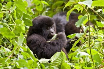
BWINDI, Uganda (AP) — In the tangled greenery of a Ugandan national park, mountain gorillas sit among the leaves, calmly carrying on as tourists trek into their forest home.
Many gorilla families are used to people, but while their population grows, the forest available to them does not.
Communities have planted trees for medicine, firewood and crafts along the edge of Bwindi Impenetrable National Park in a bid to reduce pressure on gorilla habitats.
The idea is simple: If residents can find the trees they need outside the park, they will have less reason to cut them inside the forest.
Bwindi’s forest is home to about 450 mountain gorillas, close to half the world’s remaining population. A 2018 survey put the global population above 1,000, a significant recovery for a subspecies that once faced possible extinction.
“Being a neighbor to the park, I understand that the number of gorillas is increasing, but the forest habitat is not increasing,” said Christina Katushabe, founder of Change a Life Bwindi.
Her organization supplies useful trees, restores degraded land while improving biodiversity. Katushabe said members of the Batwa, an Indigenous community that has helped guide the project, select species used for medicine, timber and firewood.
The Uganda Wildlife Authority distributes seedlings, including medicinal trees that people might otherwise seek inside the park.
Joseph Muhindo, an assistant tourism and hospitality officer with the authority, said residents can harvest what they need in their communities “without tampering with the habitat for the gorillas.”
The International Union for Conservation of Nature classifies mountain gorillas as endangered, an improvement from their earlier designation as critically endangered.
Tourism has helped support that recovery. Visitors trek through the forest to observe habituated gorilla families, generating jobs and revenue for nearby communities. Residents also sell locally made crafts.
Eunice Owembabazi, a member of a women’s crafts group, said the tree planting near the park means “we people and the gorillas do not inconvenience each other.”
The campaign has reached nearby schools, where students plant trees their families will be able to use.
“Now we are going to protect the forest, so that our gorillas can stay well,” said Davis Musinguzi, a student at Ruhijja Seed Secondary School.
The tree planting was among community conservation activities organized to mark World Gorilla Day, observed each year on Sept. 24.
By Patrick Onen, Associated Press
Banner image: A mountain gorilla encountered during a gorilla tourism trek in Uganda. Image by Hjalmar Gislason via Flickr (CC BY 2.0).
you're currently offline


