- Devastating fires and haze in 2015, as well as the threat of arrest, have prompted some villages in Sumatra to end the tradition of burning the land for planting.
- The villages of Upang Ceria and Gelebak Dalam also been fire-free since then, even as large swaths of forest elsewhere in Sumatra continue to burn.
- Village officials have plans to develop ecotourism as another source of revenue, as well as restore mangroves and invest in agricultural equipment that makes the farmers’ work easier.
UPANG CERIA/GELEBAK DALAM, Indonesia — Boat drivers sometimes decide not to work when the smoke is thick on the Musi River out of fear of a dangerous collision. For the last three months wildfires here in South Sumatra have enveloped much of the province in a dense haze. The smoke sticks to your clothes and makes it difficult to see the way forward.
“The fires make life hard for us,” Abdul Hamid, the head of Upang Ceria, a village on the Musi River outside Palembang, the provincial capital, told Mongabay in early September. “The haze makes us sick and it’s difficult for us to move around.”
In September the national aviation authority rerouted scores of domestic and international flights as visibility fell to only a few hundred meters at the airport in Palembang. Schools closed for several days in the city, costing children class time soon after the beginning of the new school year.
Satellite data on fires from the World Resources Institute (WRI) indicate there were more than 22,000 fire alerts in September in South Sumatra, 9.3 percent of the total number of alerts throughout the Indonesian archipelago. Fires here have burned on and off ever since the dry season began more than three months ago.
The fires spread easily across Indonesia’s vast peat swamp zones, which have been widely drained and dried for agriculture. Many planters also use fire to clear and fertilize the land, though the practice is illegal.
However, a handful of villages in the province have managed to stay free from fires since the catastrophic El Niño weather event in 2015, when more than half a million Indonesians were sickened by haze due to a prolonged dry season.
“For three years we have been free from any fires,” said Abdul Hamid. “Almost everyone has given up burning grass and straw.
“Now they compost it to make fertilizer.”
Upang Ceria sits mostly on peat soil and its 2,500 inhabitants occupy an area of 25 square kilometers (10 square miles). The village is located on the banks of the Musi River, which flows out to sea toward the tin-mining island of Bangka off Sumatra’s eastern coast.
Many people here used to set fires to clear land to replant crops and trees, but Addul says fear of arrest by the police or military has changed that behavior.
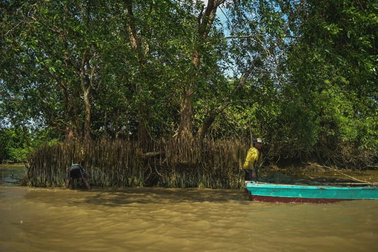
One knock-on effect of wildfires is the pressure placed on local food supply chains. But the absence of fires near the Musi River in Upang Ceria means the community can still fish in mangrove swamps on the riverbanks.

The village of Gelebak Dalam lies around 50 kilometers (31 miles) downstream of Upang Ceria. Its 2,000 or so inhabitants live surrounded by rice fields and rubber plantations.
Hendri Sani, the village chief of Gelebak Dalam, also sees clear changes in the way the community perceives the risks caused by fires to clear land. Since the catastrophic 2015 Southeast Asia haze crisis, Hendri told Mongabay, people here have begun to warn their neighbors against any open burning.
“We must turn our backs on this tradition because it is bad for the environment,” Hendri said. “Things are different now and it’s been banned by the government.”
Hendri explains how fire was an ingrained practice among farmers in Gelebak Dalam until only relatively recently.
However, better access to the heavy machinery required to work the land more productively means the community is increasingly able to bury grass, straw and other agricultural surplus into a makeshift landfill.
“We just pile it all into a hole using an excavator,” he says.
Upriver in Upang Ceria, the elders are drawing up plans to market the village as an ecotourism destination with support from the Banyuasin district government. Abdul Hamid wants to highlight to visitors the recent environmental initiatives, as well Upang Ceria’s history as one of the oldest continually inhabited places from the Srivijaya kingdom, which flourished here a millennium ago.
“We’re going to focus on tours of the Demang Lebar Daun River as well as Sekoci Island,” Abdul says.
Another idea is to restore mangrove trees along the Musi River.
“Most of the mangroves here are gone, so we’re going to replant them with help from the Banyuasin district government,” Abdul says.
The local government in Gelebak Dalam also wants to designate itself as an ecotourism destination — while continuing to make progress on reforming local agricultural practices.
“Our agriculture will actually be more advanced and free from using fire if farmers can be helped with technology and science,” Hendri says. “Because of this I’m determined to buy an excavator on credit to help the community.”
This story was first reported by Mongabay’s Indonesia team and published here on our Indonesian site on Sept. 25, 2019.
Banner: A resident of Upang Ceria displays a shrimp he caught in the Demang Lebar Daun River, a tributary of the Musi. Locals hope to attract tourists to their villages via river tours and other activities. Image by Nopri Ismi for Mongabay Indonesia.
FEEDBACK: Use this form to send a message to the author of this post. If you want to post a public comment, you can do that at the bottom of the page.


