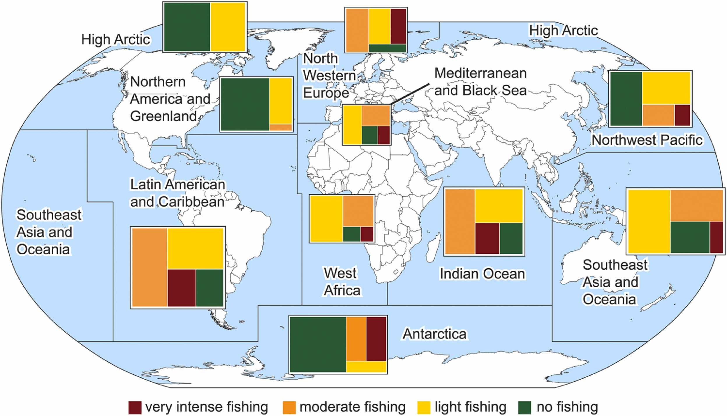
- Marine protected area (MPA) status doesn’t guarantee that conservation efforts are effective, according to new research that looks at the de facto situation of preserved areas around the world.
- A third of the MPAs analyzed appear likely to be protected only on paper, most of them in Latin America, Southeast Asia and Oceania, and the Indian Ocean.
- Researchers created a Paper Park Index (PPI) based on interviews with local stakeholders and their perceptions of fishing levels within MPAs, with the PPI showing the difference between the theoretical goals of the MPAs and the reality on the water.
- The new methodology could help provide more realistic information about the effectiveness of MPAs and support further conservation efforts, the study suggests.
Across the world, around 18,500 marine protected areas have been set up to protect sea life and the ecosystem services that oceans supply, covering about 8% of the sea surface. But according to a new study, some might not work as well in reality as they do on paper.
The research published in Marine Policy found that a third of the MPAs assessed were likely to be “paper parks,” a term used by scientists for when conservation efforts are considered ineffective. Using stakeholders’ perceptions of fishing levels occurring in each MPA, the authors looked at the differences between official conservation targets and perceived protection levels on the water.
“Databases have looked into the protection status of MPAs on the International Union for Conservation of Nature (IUCN) category – a grouping system for protected areas … but haven’t interrogated people living or working in these areas,” study lead author Verónica Relaño, a Ph.D. candidate at the University of British Columbia, Canada, told Mongabay in a video call.

Interviewees, who included academics, fishers, civil servants, journalists and NGO workers, were asked for their perception of how much fishing was occurring in a familiar MPA. “It’s a perception, but perceptions can also be data,” Relaño said.
For each MPA, the scientists compared the average fishing intensity reported by stakeholders with the MPA categories developed by the IUCN, from which they derived a “Paper Park Index” (PPI): the higher the difference between how much fishing was reported on the water and how much should occur in accordance with the IUCN, the bigger the chance that an MPA is a paper park.
Out of the 184 MPAs analyzed, 30% are likely paper parks, their results show. The majority of those are in Latin America and the Caribbean (31%), in Southeast Asia and Oceania (25%), and in the Indian Ocean (20%). Eleven MPAs, 10 of which had been identified by previous studies as “not very protective,” were found to have a higher PPI than the rest.
The study focused mostly on no-take MPAs, where fishing and extractive activities are banned, or on the no-take zones (NTZs) of an MPA that allows multiple uses. In Relaño’s view, the latter is more likely to be misfunctioning as it can be difficult to follow the different regulations set up across the same area.
Illegal fishing in Los Roques
Off Venezuela’s coast, in the Caribbean Sea, Los Roques National Park was established in 1972 to protect coral reefs, seagrass beds and coastal mangroves, becoming the country’s first MPA and the second in Latin America.
“Los Roques was one of the best protected MPAs in the Caribbean until 2013-2014,” Francoise Cabada-Blanco, teaching fellow at the University of Portsmouth, U.K., wrote in an email to Mongabay. That was before the economic and humanitarian crisis hit Venezuela a few years after. “Fishers used to respect NTZs, and that was obvious in the abundance and diversity of reef fishes as well as the state of coral reefs in the zones with the highest level of protection,” wrote Cabada-Blanco, who was not involved in the recent study.

This began to change around 2012-2013, in the context of a steep reduction in the enforcement capacity of the park’s management agency and overall governability of the MPA, which is managed by Venezuela’s National Park Institute, Cabada-Blanco said.
However, overfishing in the park isn’t a matter of poor enforcement or low management capacity, but rather a consequence of a complicated socioeconomic situation, she said. This has led to lower compliance from local fishers, weaker institutions, fewer alternatives to make a living, and unwanted impacts caused by ill-informed management decisions.
The lack of research on fishing in Los Roques in the last 10 to 15 years makes it difficult to provide fishing production data, Bladimir Rodriguez, a researcher at Los Roques Scientific Foundation, told Mongabay via email. Yet he said overfishing reports could be directly linked to Venezuela’s gas shortage and years of sanctions by the United States. “I hear that authorities do not have fuel for boats to make routine inspections,” Rodriguez said, as the area has been chronically understaffed and lacks monitoring equipment. The lack of fuel could also limit how far fishers can go, which could lead to areas closer to the coastline being overexploited.
Getting communities involved can boost conservation
In South Raja Ampat, Indonesia, the Misool Marine Reserve, located in the Southeast Misool MPA, is a conservation area spread over 1,220 square kilometers (470 square miles). All extractive practices are banned in its two NTZs, Daram and Batbitim, which are connected by a blue-water corridor that allows only low-impact, traditional uses of its waters.
The reserve was created in 2005 by local communities and the charity arm of a business running a local resort. Local rangers partner with authorities to enforce the fishing ban. Their efforts have stopped dynamite fishing and coral mining, according to reports from co-founder Misool Foundation.
Relaño said it’s important to integrate the communities whose livelihoods depend on MPAs’ ecosystems. “From planning to enforcement, all types of stakeholders must be involved, because if we don’t engage them from the beginning, why would they comply with regulations later on?” she told Mongabay. “If managers integrate stakeholders in an equitable and respectful manner, they are more likely to comply with regulations and encourage others to do the same.“

By 2030, Indonesia plans to expand the protection of its seas to an area almost the size of Germany, before tripling it to 975,000 square kilometers (376,450 square miles) by 2045. But choosing which area to protect could influence an MPA’s conservation outcomes, the study suggests. According to Relaño, governments can choose to set up MPAs in sections of the ocean that aren’t used for fishing, where there’s no special ecosystem to conserve, or that don’t cause many issues to users. “That’s how we end up with paper parks,” she said.
Regularly monitoring the results of conservation within an MPA is important for ensuring there’s no gap between its official status and perceived fishing levels, the study says, especially when MPA implementation is still imperfect.
Minna Epps, head of the ocean team at the IUCN, said MPAs can bring major benefits to biodiversity if control and surveillance efforts ensure that protections are respected. “The lack of sufficient funding and capacity to guarantee compliance has been the major issue with MPA effectiveness to date,” she told Mongabay in an email. “We see great opportunities for new technologies, including AI, to increase enforcement capacity and help stop illegal fishing and other harmful activities.”
Banner image: Image courtesy of John Griffiths via Flickr (CC 2.0).
STORY UPDATE: Since publication of the above story, the authors of the study have published a correction to the research. The following paragraph in the article should read:
“Out of the 184 MPAs analyzed, 27% are likely paper parks, their results show. The majority of those are in Latin America and the Caribbean (35%), in Southeast Asia and Oceania (16%), and in the Indian Ocean (22%). Eleven MPAs, 10 of which had been identified by previous studies as “not very protective,” were found to have a higher PPI than the rest.”
Citation:
Relaño, V., & Pauly, D. (2023). The ‘Paper Park Index’: Evaluating Marine Protected Area effectiveness through a global study of stakeholder perceptions. Marine Policy, 151. doi:10.1016/j.marpol.2023.105571
FEEDBACK: Use this form to send a message to the author of this post. If you want to post a public comment, you can do that at the bottom of the page.


