- A new study suggests an early way to detect ecological shifts during marine heat waves: Use fishing vessel tracking data.
- The study found that tracking data could provide early detection of extreme northward and inshore shifts in albacore tuna and Pacific bluefin tuna distribution in response to heat waves and showed when such shifts weren’t happening despite high sea surface temperatures.
- The authors position fishers as “apex predators” and build on research that finds that predators are good ecosystem sentinels.
Marine heat waves have become longer and more frequent along the U.S. West Coast, as elsewhere in the world. But heating doesn’t always lead fish to change their location. A new study suggests a better way to tell if such ecological shifts are happening: Use fishing vessel tracking data.
The study, published Dec. 22, 2025, in the journal Proceedings of the National Academy of Sciences, found that tracking data could provide early detection of extreme northward and inshore shifts in albacore tuna (Thunnus alalunga) and Pacific bluefin tuna (T. orientalis) distribution in response to heat waves. The data also showed when such shifts weren’t happening, despite high sea surface temperatures. Related data also showed when there was low albacore availability for fishing.
The study indicates that tracking data can in some cases be used as an early-warning signal for ecological change in the ocean, the authors suggest.
“We have so much data on fishing vessel activity,” study lead author Heather Welch, a marine spatial ecologist at the University of California, Santa Cruz, said in a statement. “These data are traditionally used for surveillance, and it is exciting that they may also be useful for understanding ecosystem health.”
Failing to quickly see changes in fish distribution can lead to “social conflicts, lack of infrastructure preparedness and overfishing,” the authors write, citing examples from Iceland and the northeastern U.S. from the last two decades.
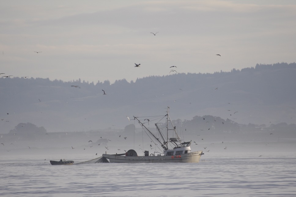
And yet, until now, the function of vessel tracking data has been rather siloed. Regulators around the world use vessel monitoring systems (VMS) data to enforce fishing rules, taking advantage of transponders on vessels that send signals on their location in near real time.
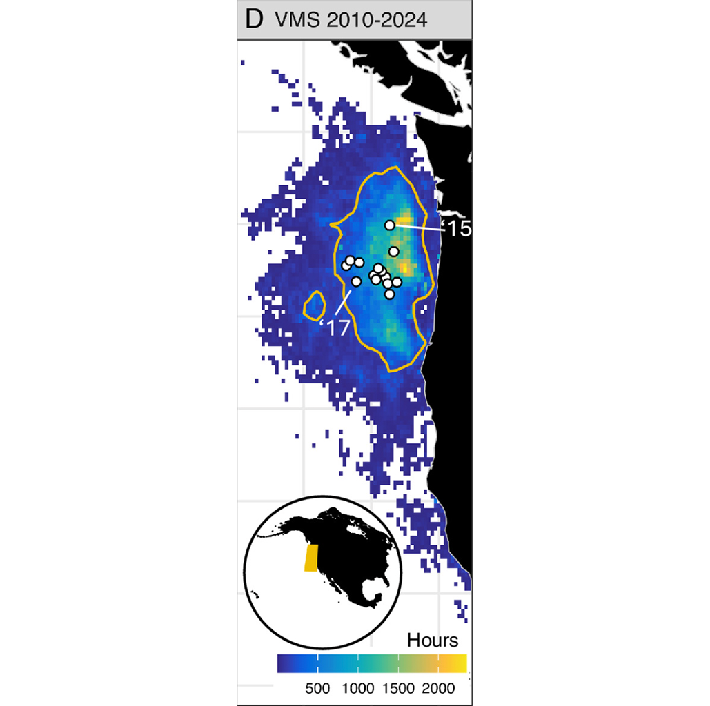
Welch and her co-authors position fishers as “apex predators” and build on research that finds that predators are good ecosystem sentinels. They’re among the first researchers to propose using VMS as a kind of alarm system for ecological change. They analyzed VMS data collected between 2010 and 2024 for the U.S. West Coast albacore and bluefin fishery, looking for sharp shifts in vessel activity northward or inshore.

The researchers faced a challenge. Because there was no large-scale tagging program during those years, there was no way to know exactly where albacore and bluefin had been, and thus no surefire way to determine how “skillful” VMS indicators were. So the researchers opted to “ground-truth” the VMS data against correlative species distribution models that estimate the location of tuna based on where tuna have moved in the past in response to environmental factors such as chlorophyll and oxygen levels.
“In a perfect scenario, we would have a large number of albacore tagged from the period of our study,” Welch told Mongabay. “And we’d be able to see exactly where they were going without using a model. But that’s so expensive, that’s so time-consuming. You often don’t have ecological data like direct observations from the time period you’re looking at.”
The authors found that VMS data generally outperformed sea surface temperature at detecting initial northward and inshore shifts of albacore and bluefin — that is, it more closely matched the model’s findings.
William Cheung, professor and director of the Institute for the Oceans and Fisheries at the University of British Columbia in Canada, told Mongabay that “temperature is important to the distributions of tuna, but it is not the only driver.”
Cheung, who wasn’t involved in the study, said it was well done and its findings made sense because fishers have tools such as sonar that can help them find tuna underwater.
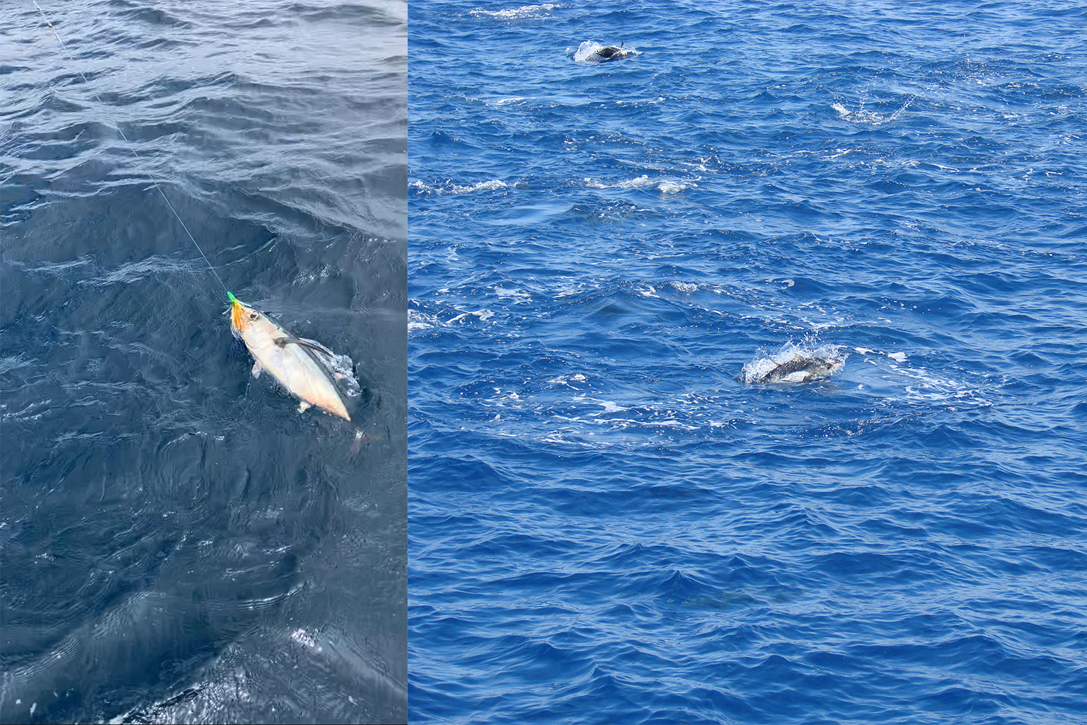
Albacore and bluefin in the eastern North Pacific tend to move northward or inshore during some heat waves. Going north is a straightforward poleward shift, and moving inshore brings the fish into an upwelling region in which cold water has come toward the surface from the ocean’s depths after meeting a continental shelf.
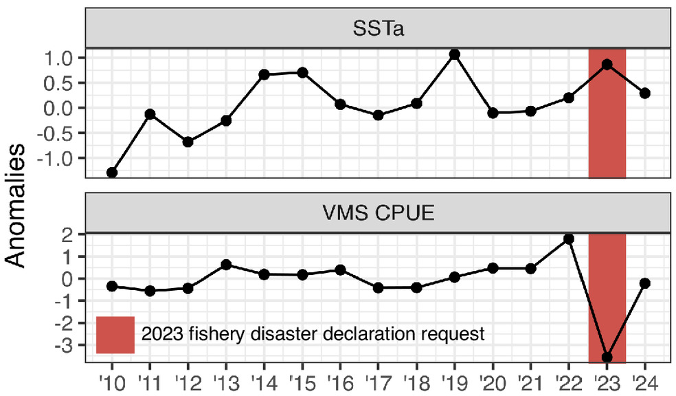
There were three major heat waves in the region during the study period: 2014-2016, 2019, and 2023. Only the first, which is known to marine scientists as “The Blob” and was devastating to marine life, caused an extreme shift in albacore and bluefin distribution. The VMS data accurately detected whether the fish would shift location in all three cases, whereas relying on sea surface temperature alone would have led to “false positives” — an expectation of an extreme shift, when none in fact occurred — in both 2019 and 2023, the authors found.
The 2023 heat wave, while not causing an extreme distribution shift, was nonetheless very impactful, as it reduced albacore catchability. (It’s not clear if fishers’ difficulty in catching albacore was due to reduced abundance, a move to deeper waters or another factor; bluefin catchability wasn’t studied because its population is rapidly recovering from a very low baseline and catch quotas are increasing, so the data would have been too noisy.) VMS-related data could have provided an early indication of the problem, the study says: Landing receipts that vessels file upon return to port show that the catch per unit of effort for albacore was dramatically lower in 2023 than in other recent years.
Using VMS and landing receipts could speed up future economic relief efforts, the authors write. For now, those efforts take time. In December 2024, some 14 months after the 2023 albacore season closed, the governors of three U.S. West Coast states filed a disaster assistance request for the albacore fishing industry due to the low 2023 catch; the request is still pending.
Simon Thorrold, a senior scientist at Woods Hole Oceanographic Institution in the U.S., who wasn’t involved with the study, applauded Welch and her co-authors for making use of vessel tracking data, which he said had been “underutilized.” He told Mongabay that the researchers are “absolutely correct” that fisheries data should be collated and used by experts to do a “better job of dragging fisheries management into the 21st century.”
Thorrold said that in some ways, the study is only able to “scratch the surface” because fine-grained data aren’t currently collected. As an example, he pointed to landing receipts, which show how much fish was collected during an entire fishing trip, which can last weeks and cover thousands of square kilometers. Thorrold said he would like to see the use of onboard cameras and artificial intelligence to get catch data on individual sets and locations.
Welch and outside experts interviewed by Mongabay, including Thorrold, agreed that determining how skillful fishers are as sentinels is a complicated undertaking. For one, fishers can choose to cast their gear at certain locations for a variety of reasons, including weather or fuel price. The authors’ analysis found those other factors, while present, weren’t key. And the more fundamental difficulty, as mentioned, was not having a definitive baseline data set to measure the VMS against. The limitations of the species distribution models are in fact what makes the VMS method important to develop.
“There is an inherent paradox in evaluating the efficacy of ecosystem sentinels: The very conditions that make ecosystem sentinels necessary — limited direct observations of ecological change — also make it difficult to ground-truth their effectiveness,” the authors write.
The authors suggest that models and VMS-based indicators could ultimately be “integrated” to provide a fuller picture of ecological change. Yet the research required to develop accurate species distribution models is extensive, and not feasible for many of the world’s fisheries. On the other hand, there is a great deal of VMS data already collected in near real time, Welch said.
However, VMS data aren’t always accessible. The U.S. government doesn’t make VMS data public, nor do most other countries or governmental bodies. Just 10 countries have made their VMS data accessible on a map managed by Global Fishing Watch, a U.S.-based NGO that publicly tracks fishing activity, which researchers or fisheries managers can access with permission. Welch’s team received the VMS data for this study from a division of the U.S. National Oceanic and Atmospheric Administration.
In any case, fast-changing ecological conditions could be determined not just by looking at VMS but also other types of tracking data, such as those from the automatic identification system (AIS), which is generally public-access and was designed for collision avoidance; it could also come from night light detections or synthetic aperture radar, Welch said.
Using tracking data to determine ecological change is better suited to species with relatively stable populations and strong sensitivities to environmental changes, the authors write. Heat waves have little influence on the distributions of bottom-dwelling fish like cod, for example.
Still, the general method applied in this study could have wider applications. There’s the “potential” to use this type of vessel tracking data to look at ecological change in “other regions,” Cheung said.
Banner image: A purse seiner targeting Pacific bluefin tuna (Thunnus orientalis) in the Pacific Ocean off the coast of Mexico. Image courtesy of Andre Boustany.
Chile pledges to make its fishing vessel tracking data public
Citations:
Welch, H., Holycross, B. M., Cluett, A. A., Jacox, M. G., Braby, C. E., Callahan, M. W., … Hazen, E. L. (2025). Fishing fleets as ecosystem sentinels. Proceedings of the National Academy of Sciences, 122(52). doi:10.1073/pnas.2516308122
Oliver, E. C., Donat, M. G., Burrows, M. T., Moore, P. J., Smale, D. A., Alexander, L. V., … Wernberg, T. (2018). Longer and more frequent marine heatwaves over the past century. Nature Communications, 9(1). doi:10.1038/s41467-018-03732-9
Spijkers, J., & Boonstra, W. J. (2017). Environmental change and social conflict: The Northeast Atlantic mackerel dispute. Regional Environmental Change, 17(6), 1835-1851. doi:10.1007/s10113-017-1150-4
Mills, K., Pershing, A., Brown, C., Chen, Y., Chiang, F., Holland, D., … Wahle, R. (2013). Fisheries management in a changing climate: Lessons from the 2012 ocean heat wave in the Northwest Atlantic. Oceanography, 26(2), 191-195. doi:10.5670/oceanog.2013.27
Hazen, E. L., Abrahms, B., Brodie, S., Carroll, G., Jacox, M. G., Savoca, M. S., … Bograd, S. J. (2019). Marine top predators as climate and ecosystem sentinels. Frontiers in Ecology and the Environment, 17(10), 565-574. doi:10.1002/fee.2125
Horemans, D. M., Friedrichs, M. A., St-Laurent, P., Hood, R. R., & Brown, C. W. (2024). Evaluating the skill of correlative species distribution models trained with mechanistic model output. Ecological Modelling, 491, 110692. doi:10.1016/j.ecolmodel.2024.110692
Feedback: Use this form to send a message to the author of this post. If you want to post a public comment, you can do that at the bottom of the page.