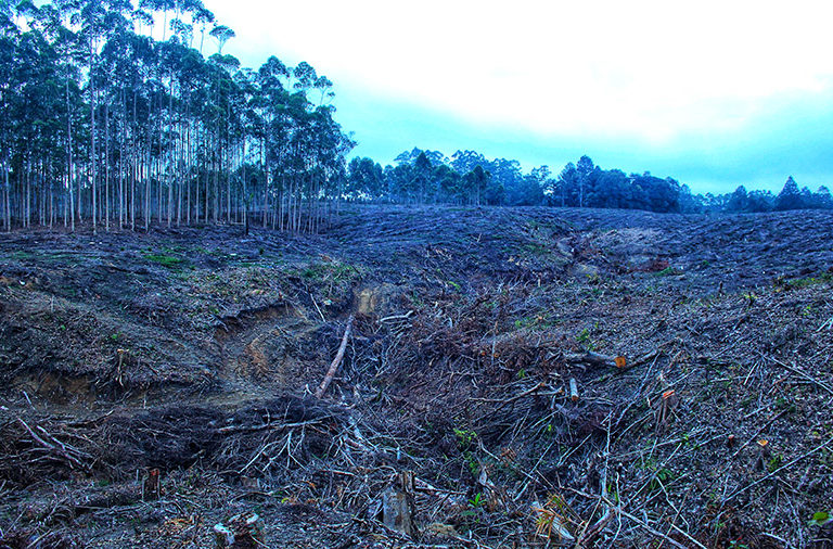
- Unallocated public areas account for 28% of deforestation in the Brazilian Amazon, and the destruction of these lands keeps rising even as rates plummet across other parts of the rainforest.
- To tackle the problem, Brazil’s federal government plans to convert lands around controversial Amazonian highways into protected areas.
- One of the priority areas is along the BR-319 highway, where experts warn deforestation may increase fourfold under another government plan to pave the highway.
- Despite the advances in comparison with former President Jair Bolsonaro, Indigenous and land reform movements are unhappy with the pace of land designation under President Luiz Inácio Lula da Silva.
As climate change wreaks increasingly devastating droughts, hurricanes and storms, preserving the world’s remaining large blocks of standing forest has become a matter of survival. However, 47 million hectares (116 million acres) of forest in the Brazilian Amazon, an area nearly the size of Cameroon, remain unprotected.
These are unallocated public lands, which aren’t designated as conservation units or intended for traditional populations like Indigenous peoples or Quilombolas, Afro-Brazilian communities established by formerly enslaved people.
“It’s a huge area without designation, which makes land grabbers or even politicians interpret it as no-man’s land,” Paulo Moutinho, senior researcher at the Amazon Environmental Research Institute (IPAM), told Mongabay.
According to Brazil’s space agency, INPE, from August 2021 to July 2022, 28% of deforestation in the Brazilian Amazon occurred in unallocated public lands. Even in 2023, when deforestation rates plummeted by half across the rainforest, these areas saw an increase of more than 30% in clearing, according to IPAM.
At the current pace of destruction, billions of tons of carbon dioxide could be released into the atmosphere, threatening the fight against global warming and the water supply in Brazil, which faced its worst drought ever recorded in 2024.
“We’re going to create a hole in the flying rivers,” Moutinho said, referring to the wind flows that take moisture from the Atlantic Ocean and the Amazon out to the rest of the country, securing water for agriculture, human consumption and energy generation. “The destination of this enormous forest mass is almost a question of the country’s security.”

In this race against time, Brazil’s government has produced a plan indicating critical federal areas to be prioritized for allocation. According to the document obtained by Mongabay through freedom of information requests, “the delay in allocating public lands puts them in the sights of land grabbers and, consequently, illegal deforestation.”
Two of the government’s four priority areas revolve around controversial roads, with an emphasis on the BR-319 road. The 880-kilometer (547-mile) highway was built in the 1970s to connect Porto Velho, the capital of Rondônia state, with Manaus, the Amazonas state capital and the largest city in the rainforest.
However, a 400-km (250-m) stretch of the road, known as the “middle section,” becomes undrivable for most of the year, making Manaus highly dependent on river transportation for the supply of goods. Some stretches of the road have no asphalt and get muddy during the rainy season, with deep puddles.
Initially fueled by former President Jair Bolsonaro (2019-2022), the prospect of repaving the road spurred a frenzy of speculative land grabbing and doubled deforestation in the area from 2020 to 2022.
“The announcement of infrastructure drives people, which generates deforestation and invasions of public lands,” Moutinho said.
Bolsonaro didn’t fulfill his promise to pave the road. But once in office, his successor, Luiz Inácio Lula da Silva, contradicted his commitments to Amazonian conservation by defending the BR-319 paving project and listing it among the government’s priorities.
“We’re going to prepare the state so that we can definitively deliver the link between Manaus and Porto Velho,” Lula said in September.

The undertaking would result in a fourfold increase in deforestation rates around BR-319, according to a report from researchers at the Federal University of Minas Gerais (UFMG). Forty conservation units and 50 Indigenous territories would be affected, including isolated Indigenous groups living in the Middle Purus region.
According to experts, paving the road would also expand soy and cattle ranching even deeper into the south of Amazonas state, where the Amazon’s best-preserved and densest forest blocks lie — and, therefore, the largest carbon stocks.
Allocating undesignated land along BR-319 could help protect the rainforest, which is why the region is among the government’s priority areas.
“There is a race against time in the case of BR-319 to establish these conservation areas, perhaps creating a buffer region along the highway,” Moutinho said, adding that Amazonas has the Amazon’s largest share of unallocated public lands, most of it is under the state’s control. “The Amazonas [state] government has a great responsibility in allocating these areas,” he said.
It wouldn’t be the first time the federal government would create a block of protected areas to minimize deforestation around highways, whose surroundings account for 50% of Amazon deforestation, according to IPAM.
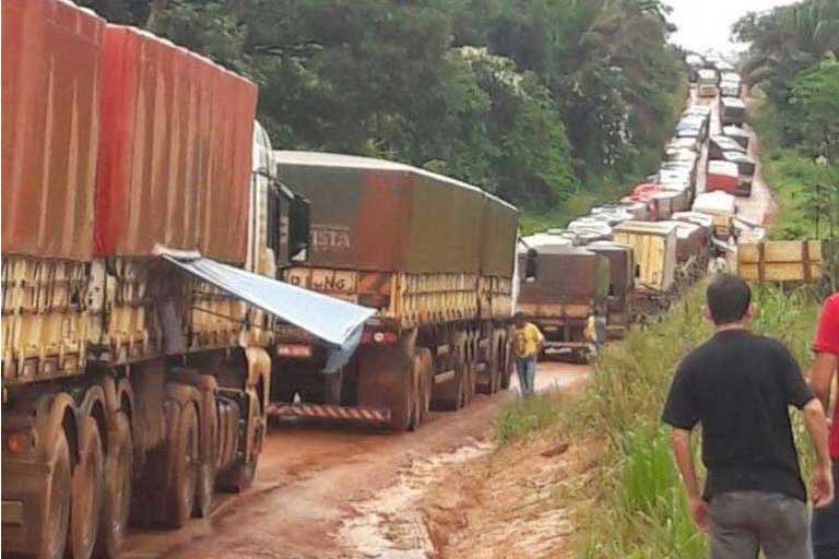
In the early 2000s, Brazil started creating several conservation units alongside another highway, BR-163, on the stretch between the north of Mato Grosso state and the ports of Itaituba and Santarém, both in Pará. The plan aimed to curb deforestation along the highway. However, the now fully paved highway brought in newcomers and boosted illegal enterprises.
Historically, official highways in the Amazon generate dozens of unofficial, smaller roads, in a phenomenon known as a fishbone pattern; from up above, these smaller roads can be seen branching off from the main one, resembling a fish spine. A recent study by Imazon, a Brazilian conservation nonprofit, identified a vast and largely undocumented network of roads in the rainforest, running a combined length of 3.46 million km (2.15 million mi).
Most of them spin off from legal highways such as BR-319 and BR-163, providing easy access for illegal miners, loggers and land grabbers. Official figures acknowledge only a small fraction of these roads — at least 86% of them are unofficial.
This vast network penetrates deep into the rainforest, with 41% of the Brazilian Amazon now either directly fragmented by roads or located within 10 km (6 mi) of one, according to Imazon. Worryingly, a significant portion of these roads, totaling 280,000 km (174,000 mi), are found within supposedly protected areas like conservation units and Indigenous territories.
Easy access led to an increase in crops and livestock, in turn driving up demand for commodity transportation. Now, local authorities and businesspeople are asking the government to increase BR-163’s capacity by adding a second lane to the highway.
The pressure for more roads and the rampant deforestation in the region led Lula’s administration to set the BR-163 region as one of the priorities for allocating undesignated land as new conservation areas. Despite the allocation effort made 20 years ago, the government says the region still has a “considerable amount” of unallocated public lands.

Progress, but not so much
Demarcating traditional territories is the most efficient way of protecting the rainforest, followed by the creation of conservation units; on Indigenous lands, for example, deforestation rates are around 17 times lower than in unprotected areas.
In Brazil, it’s up to the Technical Chamber for Land Allocation and Regularization to take the first step in this process. The group brings together different federal agencies that may show interest in a piece of federal land, including INCRA, which manages land reform settlements; Funai, the Indigenous affairs agency; and the environmental ministry, responsible for creating conservation units.
During his presidency, Bolsonaro famously refused to create any new Indigenous territories or conservation units, converting the technical chamber into a land privatization machine in favor of land grabbers.
Under Lula, Environment Minister Marina Silva has announced the allocation of undesignated public forests as one of her top priorities, promising to designate 29.5 million hectares (73 million acres) by 2027.
The first step was taken in 2023 with a decree ensuring federal forests could only be converted into conservation units, traditional territories and forest concessions, which are areas dedicated to sustainable forest management.

To date, Lula has created eight new conservation units, totaling 63.8 million hectares (157.6 million acres), an area the size of France. “There has been a big leap in political will to move forward with this designation process,” IPAM’s Moutinho said.
Despite the advances, a feeling of frustration still hangs over Lula’s policy, especially from the Indigenous side. Since taking office, Lula created 12 new Indigenous lands, falling short of what the Indigenous movement was expecting; other territories saw their demarcation process advance, but are still pending final approval.
“We had hoped that the demarcations would be moving a little faster,” Juliana de Paula Batista, a lawyer at Instituto Socioambiental, an NGO that advocates for the rights of Indigenous, Quilombola and extractivist communities, told Mongabay.
The government blames the delay in part to the marco temporal legislation, pushed by the ruralist caucus in parliament that set a cutoff date for establishing Indigenous territories: only claimant communities who can prove they occupied their territories in 1988, when Brazil’s Constitution was approved, can go through the demarcation process.

Though ruled unconstitutional by the Supreme Court in 2023, the marco temporal legislation was approved by parliament just days later, in a legal clash that led to the paralysis of many demarcation processes. “Rather than changing the legislation, the ruralist caucus wanted to muddy the waters. It was designed to turn the demarcation process into an endless obstacle course,” Batista said.
She adds, however, that this contentious legislation alone doesn’t exonerate the government. “We have a very weakened government in the face of agribusiness. It has to make many concessions, and the Indigenous agenda is the first that any government negotiates.”
The frustration with the pace of land designation extends to the landless workers’ movement, or MST, which expressed high hopes for the Lula administration after four years of open confrontation with Bolsonaro. However, their first meeting with Lula took place more than one and half years after he took office, in an atmosphere of harsh discontent.
“At that meeting, we listed some very emblematic, long-standing cases that the government had to step in and resolve,” said Claudinei dos Santos, an MST leader in Rondônia state, referring to sensitive cases that could quickly end in violence. “And this has been going on until today. Nothing has moved forward.”
Just in Rondônia, around 1,000 families are camped in provisional areas, waiting to go to a land reform settlement. Across the whole country, this number jumps to 120,000 families, according to MST. In April, Lula announced a new land reform program aimed at settling 74,000 families by 2026.
Banner image:Lula promised to pave a stretch of BR-319 that remains undriveable for most of the year. Without a reliable road link, the city of Manaus remains highly dependent on river transport. Image courtesy of Marcio Isensee e Sá/InfoAmazonia.
Road network spreads ‘arteries of destruction’ across 41% of Brazilian Amazon
FEEDBACK: Use this form to send a message to the author of this post. If you want to post a public comment, you can do that at the bottom of the page.


