- A new report from Colombia’s Inspector General’s Office shows that between October 2024 and March 2025, about 88,800 hectares (about 219,400 acres) of forest were cleared and 1,107 kilometers (688 miles) of irregular roads slashed through seven deforestation hotspots.
- In all these critical areas — Río Naya, Meta-Mapiripán, Vista Hermosa-Puerto Rico, Triple Frontera (Guaviare), Llanos del Yarí – northern Chiribiquete, Caquetá and Putumayo — there was a direct relationship between the expansion of irregular roads, deforestation and coca crops.
- Experts warn that irregular roads fuel permanent deforestation, opening the door to land-grabs as well as armed actors and their illicit activities.
- Colombia reduced deforestation by 36% from 2022-23, reaching the lowest level recorded in 23 years. But deforestation has since increased again, and the government struggles to keep protected areas from being chopped away to make room for illegal roads and coca crops.
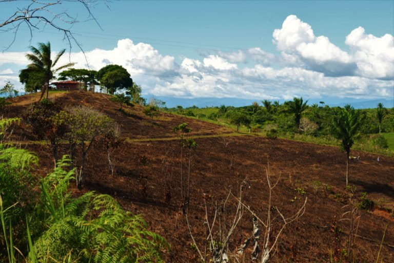
MOCOA, Colombia — From the air, the forests in Putumayo, Colombia’s southwestern Amazonian department, look scarred. Light brown lines snake through the canopy. In the eastern part of Putumayo’s Puerto Guzmán municipality, about 80 kilometers (50 miles) of irregular roads, mostly dirt tracks, cut through the forests, according to the report. Many of them are flanked by bare land where trees once stood. From October 2024 to March 2025, more than 11,000 hectares (about 27,000 acres) of forest have been lost in Putumayo.
Colombia’s southwestern department is one of the seven areas featured in a new report documenting recent expansion of deforestation in biodiversity hotspots, driven especially by illicit crops and illegal roads. The areas chosen have higher historical levels of deforestation than other regions in the Colombian Amazon.
According to Colombia’s Inspector General’s Office, between October 2024 and March 2025, 88,808 hectares (about 219,400 acres) were deforested across Río Naya, Meta-Mapiripán, Vista Hermosa-Puerto Rico, Triple Frontera (Guaviare), Llanos del Yarí – northern Chiribiquete, Caquetá and Putumayo. The Inspector General’s Office monitored an area of about 3.3 million hectares (8.1 million acres), roughly the size of Belgium. The report, supported by data from the Foundation for Conservation and Sustainable Development (FCDS), a Colombian environmental conservation nonprofit, also highlights 1,107 km (688 mi) of irregular roads associated with forest loss: 782 km (486 mi) were identified by the General Inspector’s Office between March 2024 and March 2025 and are subject to verification by local authorities; the remaining were identified by FCDS between April 2023 and March 2024.

Irregular roads often lead to permanent, large-scale forest loss, not just isolated tree clearing. They give armed groups access, enable land use change — often for extractive activities like cattle ranching and coca cultivation — and fragment biodiverse habitats, explains Joaquín Carrizosa, senior adviser at World Resources Institute in Colombia. By March 2024, there were 28,091 km (17,455 mi) of roads cutting through the Colombian Amazon, according to the Amazon Observatory of Socio-Environmental Conflicts, a platform developed by FCDS.
“When we talk about deforestation, it is not just about the number of hectares [deforested], but also about where those hectares are,” Carrizosa says. Colombia is the world’s most biodiverse country per square kilometer, and the critical zones monitored by the Inspector General’s Office are of high ecological value, according to local experts. Chiribiquete Park and Tinigua National Natural Park, spread over the departments of Caquetá, Guaviare and Meta, are among the hardest hit by deforestation, according to Rodrigo Botero, director of FCDS. Between October 2024 and March 2025, Caquetá lost 29,706 hectares (73,405 acres), followed by Llanos del Yarí and northern Chiribiquete (15,755 hectares or 38,931 acres), Meta-Mapiripán (13,782 hectares or 34,056 acres) and Putumayo (11,623 hectares or 28,721 acres).
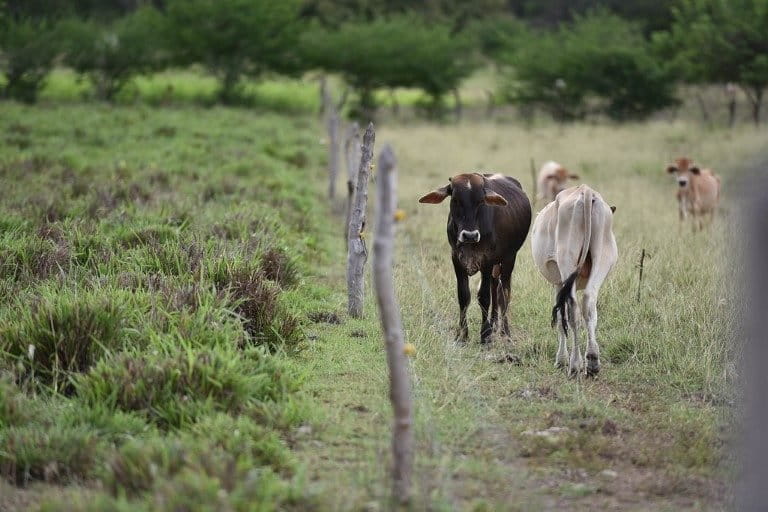
The expansion of the agricultural frontier, indiscriminate logging and unsustainable practices in extensive cattle ranching, illicit crops and illegal mining — often linked to the construction of illegal roads — are the main drivers of deforestation in Colombia, according to Johana Herrera, an analyst in natural resources legality at WWF Colombia. “These factors are usually connected to the pursuit of short-term economic gains, and behind them, illegal actors are often involved,” she says.
“Irregular roads are currently the main early warning indicator of deforestation in the Amazon, primarily because they are the trigger for settlement processes, as well as livestock expansion and, in some cases, coca cultivation,” Botero says. According to him, more than 90% of deforestation in the Colombian Amazon occurs less than 2 km (1.2 mi) from a road. Cattle ranching, the biggest driver of permanent land use change, is concentrated around such irregular roads, Botero says.
For irregular roads, “The line between legality and illegality often becomes blurry,” Carrizosa says. Many irregular roads end up serving both legal and illegal uses — even by the state — reinforcing their existence. Many irregular roads are indeed formalized over time, sometimes through public investment, Botero explains. “This happens due to the state’s inability to create roads within the legal framework and to provide solutions to the communities’ needs,” he concludes.
The opening of irregular roads has increased — especially in areas such as Meta-Mapiripán and El Retorno, Miraflores and Calamar in the Guaviare department — and has become one of the main causes of deforestation in the Amazon, Lena Yanina Estrada Añokazi, the minister of environment and sustainable development, tells Mongabay in a written response.
She adds that the ministry is working with Colombia’s security forces through the national council to combat deforestation to dismantle the criminal infrastructures that harm the environment by strengthening satellite monitoring, criminal investigations and community work to prevent the construction of new roads.
Yet, irregular roads are not just the creation of Colombia’s armed groups; they also have been ordered by the Colombian government. Under Plan Colombia, a U.S.-backed aid and military program launched in 2000 to combat criminal groups, and through various other economic development programs, the state itself promoted road building. “It is what people ask for and what farmers need,” says Estefanía Ciro Rodríguez, founder of the Colombian Amazon think tank AlaOrillaDelRío. Ciro Rodriguez describes a constant tension between the environment ministry, whose “overly rigid environmentalism has prevented constructive dialogue” and the agriculture ministry, whose “peasant communities have also been disconnected.” This lack of collaboration, she says, has led to the failure to establish effective land use planning. Ciro Rodriguez argues that perhaps Colombia needs to question whether farming and economic activity should even take place in such remote areas.
The struggle with forest loss
Colombia’s fight against deforestation has not been linear. In 2023, the country celebrated its lowest level of deforestation in 23 years, having cut forest loss by 36% from the previous year. This was partly due to payments to farmers for protecting forests and deforestation bans by some armed groups. For example, after warlord Iván Mordisco ordered a ban in areas he controlled, deforestation in the Colombian Amazon fell 76% in the first quarter of 2023 compared with the same period in 2022. “Such no-deforestation orders by a criminal actor are the reverse side of governance in Colombia,” Carrizosa says. “In reality, enforcement often depends heavily on armed groups,” he adds.
But in 2023 and 2024, as peace talks faltered and extractive industries expanded, deforestation surged by 35%.
In the first quarter of 2025, the environment ministry reported a 33% decrease in forest loss compared to the same period in 2024. The Inspector General’s report highlights, however, that certain parts of the country remain highly vulnerable as illegal road expansion and coca cultivation continue to drive deforestation.
The Colombian Ministry of Environment and Sustainable Development has its own monitoring system, the Forest and Carbon Monitoring System of the Institute of Hydrology, Meteorology and Environmental Studies (IDEAM), which identified 18 active deforestation hotspots in the first quarter of 2025 — more than those highlighted in the Inspector General Office’s report. This is due to different methodologies for measuring deforestation. IDEAM, which uses a different methodology than the Inspector General’s Office to measure deforestation, includes additional deforestation hotspots like Serranía de San Lucas, Catatumbo, Arauca and the Northern Pacific like Chocó and Córdoba.
The Inspector General’s Office has developed its own tool for identifying the areas with the highest deforestation levels included in the report, according to a written response from the authority to Mongabay. The office’s methodology focuses on the dry season in the Amazon (October to March), when most deforestation typically occurs, and reports forest loss at a more granular level than IDEAM, which reports deforestation every trimester.
Colombia’s irregular roads reflect a broader dynamic of expansive extractivist interests, both legal and illegal, according to Herrera. The report highlights illicit crop cultivation as a key driver of deforestation, particularly in the departments of Putumayo state, Valle del Cauca and Cauca. The state is one of the biggest coca producers in Colombia, which, in turn, is the world’s top supplier and fastest-growing cocaine producer, according to a recent report published by the United Nations Office on Drugs and Crime.
Due to its size, people used to think of the Amazon as an immense forest that would never run out, explains Claudia Castillo Ruiz, an Afro-descendent member of the Guardians of Water in Puerto Asís, a local environmental group in Putumayo.
She says locals started seeing the impacts of extractive activities, especially in the rivers, as they dried out and made it hard to navigate in certain parts of the department. Deforestation can lead to stronger droughts. “Before you couldn’t talk much about deforestation, but today people are more conscious,” Castillo Ruiz says. They understand the interconnections better. “If one neighbor deforests, it translates into losses for the entire community, she says.
The government has prioritized coca supply reduction through coca crop substitution programs that pay farmers to switch from coca to legal crops. More recently, it has also used chemical fumigation, a strategy Colombian President Gustavo Petro reinstated in April 2025. This move came amid threats of the U.S. no longer recognizing Colombia as a country cooperating on the war on drugs, which could put at risk about $70 million in annual military aid from the U.S. Yet, previous coca crop substitution programs have been “environmentally harmful and ineffective and actually increased deforestation,” says Beatriz Irene Ramos, an investigator at the Center for the Study of Security and Drugs (CESED) at the University of the Andes in Colombia. “Crop fumigation was devastating,” Susana Muhamad, Colombia’s former minister of environment and sustainable development, told Mongabay.
According to Ciro Rodriguez, the focus on crime in the Amazon has gone too far. “There’s a criminalization of the territory and actors,” she says. Ciro Rodriguez argues that more prohibition and police have failed to reduce crime and deforestation in Colombia’s Amazon.
Protected lands under pressure
The report has also documented deforestation and illicit activities in and near national parks and Indigenous reserves. Other sources have found significant deforestation linked to illicit activities in protected areas too. In 2020, almost half of Colombia’s coca cultivation area was inside Special Management Areas like Afro-Colombian community councils (15.5%), Indigenous reserves (8%) and national parks (4%), according to CESED.
The deforestation inside national parks “reflects the weakness of our institutions in prevention and control, as well as the lack of environmental awareness and respect for conservation designations by agents who promote deforestation in these areas,” Herrera says.
The report warns that deforestation is erasing both vast stretches of forest and small, vital fragments. “It is a lot harder to restore large patches of forest, according to Botero. He adds that the large swaths of deforestation are often linked to bigger projects with more financial power involved, whereas the smaller areas cleared are more likely to be linked to small-scale vulnerable farmers in need of agrarian reform.
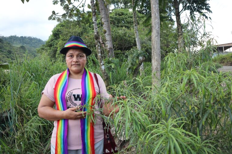
Waldina Muñoz, an Indigenous Pasto woman who leads Guardians of the Forest, a group of Indigenous women who denounce extractive activities in their home in Putumayo, has received repeated death threats for her work.
Colombia is the world’s most dangerous country for environmental and land defenders; in 2023, it recorded more killings than any other nation.
Herrera says defenders must receive better protection, and the government must work to implement the Escazú agreement for environmental defenders. “Defenders’ roles are vital for biodiversity conservation, climate change mitigation and adaptation and pollution prevention — challenges that directly impact people’s well-being,” she says.
Preventing further forest loss
“For the Office of the Inspector General, the objective is to develop preventive monitoring” through a focused and periodic study, the General Inspector’s Office says in a written response to Mongabay.
The General Inspector’s Office’s preventive approach attempts to detect early changes in land cover that do not yet constitute consolidated deforestation, “with the aim of generating alerts and mobilizing conservation actors before the damage becomes irreversible,” they say in a written response to Mongabay. “Our figures are presented as approximate or tentative, since the objective of this report is to anticipate events and promote timely action,” they explain.
The General Inspector’s Office sees its report as a complement to, not a substitute for, IDEAM’s deforestation reporting. Since IDEAM publishes its deforestation data with 4-7 months delay, the General Inspector’s Office found it necessary to use different data to be able to ensure preventive actions. The General Inspector’s Office also saw a need to share more data on certain drivers of deforestation, like irregular road construction and coca cultivation.
In its report, the General Inspector’s Office requires regional governments, municipalities and environmental authorities to explain what steps they’ve taken to protect the Amazon — and urges immediate, concrete action to stop illegal road expansion.
Estrada Añokazi says the environment ministry is working to strengthen ties with local communities living in deforestation hotspots, offering payments for environmental services and forest management plans, while targeting the criminal structures behind the scourge.
She points to the government’s Comprehensive Plan for Containing Deforestation, a strategy that blends community agreements (especially with Indigenous Peoples, Afro-Colombian communities and small farmers who commit to forest conservation); stronger collaboration with local authorities and academia, beefed-up criminal investigations, and an environmental peace agenda backed by security force deployment to curb forest loss. The plan is backed by international funding and has received at least 35 million euros ($41 million) from Germany and Norway.
But Ciro Rodriguez warns that any discussion about deforestation, closing the agricultural frontier and protecting the Amazon can only be effective if there is dialogue with local organizations and communities, but “that has not happened,” she says.
“There has always been abandonment of the state here [in Putumayo],” Castillo Ruiz says.
The starting point, according to Herrera, is to strike a balance between conserving protected areas “while also guaranteeing the fundamental rights and livelihoods of populations living in vulnerable conditions.” Resolving conflicts around land use and access lies at the heart of that effort, she says.
Banner image: A part of Putumayo rainforest showing areas of deforestation. Image courtesy of Natalia Pedraza Bravo.
FEEDBACK: Use this form to send a message to the author of this post. If you want to post a public comment, you can do that at the bottom of the page.