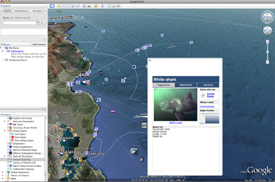
Google Earth now allows users to dive beneath the surface of the world’s oceans to see coral reefs, trenches, and other marine wonders. The new version, Google Earth 5, includes layers showing locations of shipwrecks and surf spots; routes for ocean expeditions; the movements of GPS-tracked sea animals; and information (including videos and images) about the ocean environment from sources including National Geographic, the Cousteau Society, the International Union for Conservation of Nature (IUCN), the Monterey Bay Aquarium, and the National Oceanic and Atmospheric Administration (NOAA).
John Hanke, the director of Google Earth, highlighted the additions in a blog post on the Official Google Blog:
-
We have always had a big blue expanse and some low-resolution shading to suggest depth. But starting today we have a much more detailed bathymetric map (the ocean floor), so you can actually drop below the surface and explore the nooks and crannies of the seafloor in 3D. While you’re there you can explore thousands of data points including videos and images of ocean life, details on the best surf spots, logs of real ocean expeditions, and much more.
 The Animal Tracking feature of Google Earth 5. |
Carl Gustaf Lundin, head of IUCN’s Global Marine Programme, said the new application will help conserve oceans and marine life.
“With ‘Ocean in Google Earth’ everybody can see the unbelievable beauty of our marine life – and how incredibly threatened it is,” he said in a statement. “We hope this major technological innovation will get the public more involved in marine conservation and encourage governments and businesses to stop driving ocean species to extinction.”
“Oceans cover 71 percent of the surface of our planet and provide 98 percent of the living space for life on Earth,” added Monterey Bay Aquarium Executive Director Julie Packard. “Ocean in Google Earth is a great tool to help people understand this vast habitat so we can protect the oceans for future generations.”
The new version was unveiled at the recently opened California Academy of Sciences in San Francisco’s Golden Gate Park.

Photos: Google Earth used to find new species
(12/22/2008)
Scientists have used Google Earth to find a previously unknown trove of biological diversity in Mozambique, reports the Royal Botanic Gardens in Kew. Scouring satellite images via Google Earth for potential conservation sites at elevations of 1600 meters or more, Julian Bayliss a locally-based conservationist, in 2005 spotted a 7,000-hectare tract of forest on Mount Mabu. The scientifically unexplored forest had previously only been known to villagers. Subsequent expeditions in October and November this year turned up hundreds of species of plants and animals, including some that are new to science.
Google Earth reveals cattle have a built-in compass
(08/25/2008)
Cattle, along with grazing deer, tend to align themselves with the Earth’s magnetic field lines, in a north-south direction, report researchers writing in the early online edition of the journal Proceedings of the National Academy of Sciences (PNAS). The finding suggests that cows seem to have a built-in magnetic compass.
New Google Earth layer offers insight on global deforestation
(06/15/2008)
A new Google Earth KML file presents a geographical account of global deforestation.

Amazon Indians use Google Earth, GPS to protect forest home
(11/15/2006)
Deep in the most remote jungles of South America, Amazon Indians are using Google Earth, Global Positioning System (GPS) mapping, and other technologies to protect their fast-dwindling home. Tribes in Suriname, Brazil, and Colombia are combining their traditional knowledge of the rainforest with Western technology to conserve forests and maintain ties to their history and cultural traditions, which include profound knowledge of the forest ecosystem and medicinal plants. Helping them is the Amazon conservation Team (ACT), a nonprofit organization working with indigenous people to conserve biodiversity, health, and culture in South American rainforests.


