- The amount and distribution of above ground biomass (or the amount of carbon contained in vegetation) in the Amazon basin is largely unknown, making it difficult to estimate how much carbon dioxide is produced through deforestation and how much is sequestered through forest regrowth.
- To address this uncertainty, a team of scientists from Caltech, the Woods Hole Institute, and INPE (Brazil’s space agency), have developed a new method to determine forest biomass using remote sensing and field plot measurements.
- The researchers say the work will help them better understand the role of Amazon rainforest in global climate change.
The amount and distribution of above ground biomass (or the amount of carbon contained in vegetation) in the Amazon basin is largely unknown, making it difficult to estimate how much carbon dioxide is produced through deforestation and how much is sequestered through forest regrowth. To address this uncertainty, a team of scientists from Caltech, the Woods Hole Institute, and INPE (Brazil’s space agency), have developed a new method to determine forest biomass using remote sensing and field plot measurements. The researchers say the work will help them better understand the role of Amazon rainforest in global climate change.
Writing in Global Change Biology, carbon cycle scientists led by Dr. Sassan Saatchi of the Jet Propulsion Laboratory at the California Institute of Technology (Caltech) report a new method for estimating the distribution of biomass over the Amazon basin.
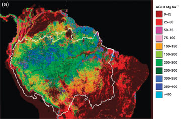
 Aboveground live biomass (AGLB) class map of terra firme old growth forests derived from the decision rule classifier and multiple layers of remote sensing data. ©2007 the Authors |
“By collecting data from a large number of biomass plots in a variety of forest types distributed over the basin, and by using remote sensing data sensitive to forest characteristics and environmental variables, we develop a series of metrics for extrapolating the plot data to the basin,” they write. “The approach combines the strengths of both forest plots (limited in spatial coverage but providing accurate measurement of biomass) and remote sensing data (less accurate in measuring biomass directly but covering the entire region).”
The new method helps overcome some of the sources of ambiguity for estimates of biomass in the region, including “uncertainties associated with measurements at individual plots and… uncertainties in extrapolating data from individual plots to the entire basin.”
Applying the new approach to the Amazon basin, the researchers found that above ground biomass levels are highest in the Central Amazon where biomass ranges from 300-400 metric tons of carbon per hectare (roughly 120-160 tons per acre). Regions to the east and the north along Brazilian coast and Guyanas had similar biomass values while the western Amazon (i.e. the lowlands of Peru, Ecuador, Colombia, and Bolivia) ranges from 200-300 metric tons per hectare. The areas with the highest biomass include “relatively intact forests” due to “low human population, low agricultural potential, low commercial timber volume, and inaccessibility.”
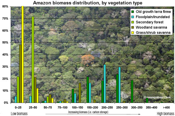
 The biomass range (metric tons per hectare) for general vegetation types in the Amazon Basin. The authors report the following distribution of vegetation category for the basin: Old growth terra firme forest (62.3% of the legal Amazon [(8 235 430 sq km]); Floodplain and inundated forest (4.19%); Secondary forest (1.67%); Woodland savanna (24.47%); and Grass/shrub savanna (4.79%). The authors report average biomass ranges as follows: Dense forest 272.5 Mt/ha, Open forest 200.2 Mt/ha, Bamboo forest 212.3 Mt/ha, Liana/dry forest 189.7 Mt/ha, Seasonal/deciduous forest 225.6 Mt/ha, and Varzea flooded forest 248.3 Mt/ha. Image produced by Rhett A. Butler using data from the authors. |
Surprisingly, the researchers found little correlation between vegetation type and forest biomass.
“Biomass is extremely variable, and to a large extent independent of vegetation types found in the Amazon basin. Therefore, extrapolation approaches that assign vegetation types an average biomass value are unlikely to capture this variability,” Dr. Saatchi told mongabay.com.
Unsurprisingly, they found that secondary forest and deforested areas have lower levels of above ground biomass.
However, as expected, climate plays an important role in the formation and distribution of the biomass and carbon accumulation in the Amazon basin. By comparing the biomass distribution and climate variables, the authors found that areas with short dry season and highest precipitation during driest quarter occupy the largest forest biomass.
The results suggest that future deforestation in the Amazon could be more damaging to climate than previously thought. Remaining forests appear to lock up larger amounts of carbon and interact closely with the climate. Clearing these forests, not only would release some of their stored carbon into the atmosphere as greenhouse gases, but may adversely impact the regional or global climate.
Richard A. Houghton, a co-author of the study and a Woods Hole Research Center expert on the global carbon cycle, says that while the function of forests in carbon sequestration is understood, it is unclear how much carbon is stored and released by forests.
“Carbon is removed from the atmosphere (and sequestered on land) when forests are growing. It is released to the atmosphere when forests are burned, or when they are cleared for agriculture,” he told mongabay.com via email. “The net effect, globally, is uncertain. Most forests are growing and thus sequestering carbon, but the amount of carbon sequestered is difficult to know because rates of sequestration vary with type of forest, its age, and soil fertility.”
 Aboveground live biomass classification and the spatial accuracy assessment: (a) biomass map of the Amazon basin at 1 km spatial resolution derived from combined decision tree method and regression analysis with 11 biomass classes and overall accuracy of 88%. ©2007 the Authors |
“Similarly, although satellite data are used to document the areas of forest cleared, logged, burned, or otherwise disturbed each year, the emissions of carbon from these disturbances are difficult to know because the amount of carbon held in forests is variable and not generally known, especially in tropical regions,” he explained. “[Our] paper discusses the role that forest biomass plays in determining the sequestration and emissions of terrestrial carbon.”
“By developing accurate biomass distribution over other regions in the tropics using similar remote sensing and field techniques, we can improve our estimates of carbon emissions and sequestration,” Dr. Saatchi added.
Looking at the Amazon basin specifically, the researchers estimate the total biomass is around 86 petagrams (86 billion metric tons) of carbon–for comparison, 7.9 billion metric tons of carbon dioxide were emitted in 2005. This means that Amazon locks up at least 11 years of recent carbon dioxide emissions, though clearing the Amazon would have a disproportionate impact due to its role in global weather regulation and other ecosystem services.


