Features
Videos
Podcasts
Specials
Articles
Shorts
Donate
English
Español (Spanish)
Français (French)
Bahasa Indonesia (Indonesian)
Brasil (Portuguese)
India (English)
हिंदी (Hindi)
Videos
Podcasts
Articles
Short News
Feature Stories
The Latest
Explore All
Mapping News
RSS
208 stories
L
G
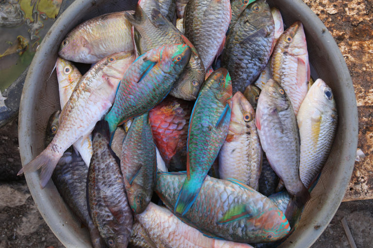
Monitoring hack shines a light on fishing boats operating under cover of dark
Basten Gokkon
17 May 2019
Counting on eDNA for a faster, easier way to count coral
Stephanie Parker
8 May 2019
‘Judas’ snakes lead scientists on a high-tech Easter egg hunt for pythons
Sue Palminteri (1965-2019)
24 Apr 2019
Panamanian indigenous people act to protect the forest from invading loggers
Guido Bilbao
2 Apr 2019
How land grabbers co-opt indigenous ritual traditions in Papua: Q&A with anthropologist Sophie Chao
The Gecko Project and Mongabay
28 Mar 2019
New map shows every forest matters in helping save the Javan leopard
Gianluca Cerullo
26 Feb 2019
The odor side of otters: Tech reveals species’ adaptations to human activity
Visvak P.
25 Feb 2019
New space lasers offer best 3D look at global forests yet
David Klinges
18 Jan 2019
Can satellite data help monitor sustainable rural development?
Sue Palminteri (1965-2019)
17 Jan 2019
Protecting India’s fishing villages: Q&A with ‘maptivist’ Saravanan
Mahima Jain
10 Jan 2019
Machine learning tool helps prioritize plants for conservation
Sue Palminteri (1965-2019)
3 Jan 2019
10 ways conservation tech shifted into auto in 2018
Sue Palminteri (1965-2019)
28 Dec 2018
2018’s top 10 ocean news stories (commentary)
Douglas McCauley, Francis Joyce
24 Dec 2018
Illegal mining in the Amazon ‘not comparable to any other period of its history’
Kimberley Brown
20 Dec 2018
Photos highlight evolving roles of AI, citizen science in species research
David Klinges
17 Dec 2018
One map to rule them all: Indonesia launches unified land-use chart
Basten Gokkon
13 Dec 2018
In pursuit of the rare bird that vanishes for half the year
Abhaya Raj Joshi
27 Nov 2018
Panama, Namibia plan to reveal fishing fleet data via online map
Basten Gokkon
19 Nov 2018
Radar helps Kenya map mangroves and other cloud-covered forests
Gatonye Gathura
15 Nov 2018
Satellite technology unites Kenyans against bush fires
David Njagi
9 Nov 2018
The iNaturalist species data sharing platform reaches one million users
Sue Palminteri (1965-2019)
19 Oct 2018
Real-time plantation map aims to throttle deforestation in Papua
Hans Nicholas Jong
18 Oct 2018
Study games out oil palm development scenarios in Borneo
Loren Bell
17 Sep 2018
Indonesian mine watchdog sues government for concession maps
Indra Nugraha
13 Sep 2018
DNA database helps Nepal’s officials monitor tigers, punish poachers
Abhaya Raj Joshi
7 Sep 2018
Underwater tech unlocks the secrets of The Bahamas’ Exuma Sound
Catherine Morris
30 Aug 2018
Indonesia’s ‘one-map’ database blasted for excluding indigenous lands
Hans Nicholas Jong
10 Aug 2018
Industrial fishing fleets traveling farther to reel in fewer fish
Mongabay.com
8 Aug 2018
Combining aerial imagery and field data estimates timber harvest and carbon emissions
Neha Jain
27 Jul 2018
Global marine wilderness has dwindled to 13 percent, new map reveals
John Cannon
26 Jul 2018
Southeast Asian deforestation more extensive than thought, study finds
Sue Palminteri (1965-2019)
18 Jul 2018
Indigenous peoples control one-quarter of world’s land surface, two-thirds of that land is ‘essentially natural’
Mongabay.com
17 Jul 2018
« Previous
1
2
3
4
5
…
7
Next »
you're currently offline