- The devastating Cyclone Ditwah has left a trail of destruction over 25 districts in Sri Lanka and killed 474 people; among the hardest-hit are those inhabiting low-lying coastal areas and the tea growing Central Highlands.
- Increasing vulnerability to extreme weather events among littoral populations is exacerbated by high population density, experts say.
- More than one-third of the Sri Lankan population, or more than 4.5 million people, live along the coastline and population density is projected to reach 134 people per square kilometer by 2050.
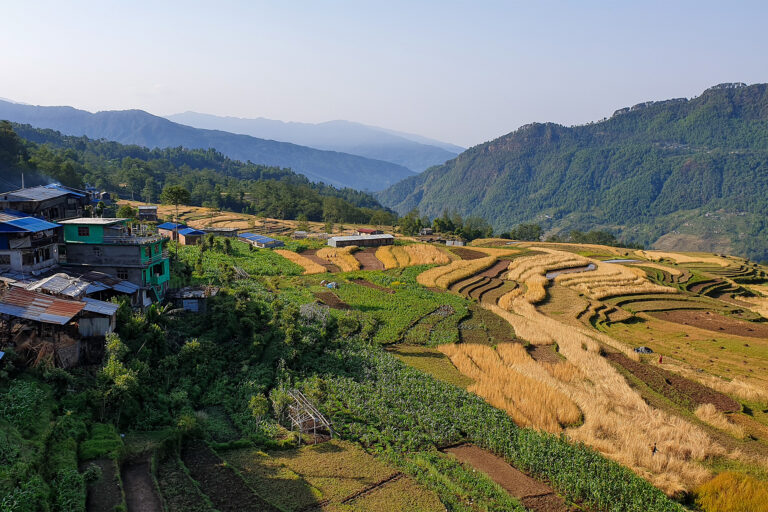
- Nearly 34% of the island population lives in high-risk landslide-prone areas of the country, making the island’s central hills highly susceptible to disaster impacts.
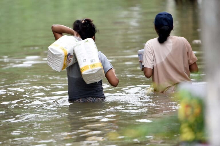
KOLONNAWA, Sri Lanka — When Denuwarage Kusumalatha (54) saw flood water reach her doorstep in the wee hours of Nov. 29, it was already too late. A resident of Kolonnawa, a town situated within Sri Lanka’s commercial district of Colombo, she rushed out of her home, with her most important belongings and family members to seek shelter at a nearby school. The relief center housed dozens of people from his neighborhood who had evacuated hours before Cyclone Ditwah hit the Indian Ocean island with alarming force, causing the mighty Kelani River to overflow and flood the plains.
The official death toll due to the cyclone stands at 474 at present. Unlike Kusumalatha, many others failed to reach safety on time, leaving nearly 1.6 million displaced and 356 reported missing.
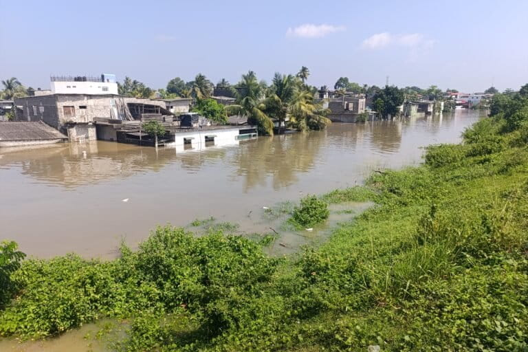
In 2016, flash and river floods claimed many lives in Sri Lanka and displaced many others. Kusumalatha’s hometown was identified as a severely flood-affected administrative area in Colombo. The reason is clear: Kolonnawa lies nearly 70% below sea level and saw more than 100,00 people forced out of their low-lying homes as the Kelani River overflowed in Ditwah’s aftermath. “Our houses were flooded in 2016, and in 2017. But never like this,” she says.

A 2021 study conducted by Indunil Ranwella and Nishan Sakalasooriya on adaptation strategies for flood victims in major river basins upheld Megoda-Kolonnawa area’s highly vulnerable status. The study, conducted in the aftermath of the 2016 deluge, also delves into mitigation needs.
“We had to restart life from scratch after the 2016 urban floods. I cannot imagine having to go through another disaster. It had taken a toll on us. We also did not receive any flood relief still,” Kusumalatha tells Mongabay.
“Kolonnawa is a highly urbanized area. Due to the value of prime lands, people purchase lands despite it being a flood-prone area,” Kusumalatha adds.
Over the years, areas such as Megoda-Kolonnawa have become prime locations for people to set up businesses and commute to work in Colombo. The 2021 study noted the area to be highly flood-prone and acknowledged the buying spree, as people prefer to buy lands and houses due to convenience and proximity to Colombo despite increasing bad weather events. This also means large numbers are exposed whenever a disaster strikes.
When Cyclone Ditwah hit, the swelling river waters caused irreversible damage to life and property in several low-lying settlements along the Kelani River Basin in Kolonnawa, Angoda, Kohilawatta and Kotikawatta regions.
One reason for the Kelani River to reach critical flood levels is the opening of spill gates in Maussakelle and Castlereigh reservoirs, which flow toward the Kelani River.
Increased rainfall
Speaking to Mongabay, Sarvajith Priyankara Herath, director of water management at the Irrigation Department, says this November, the country has experienced “abnormal” weather where certain places experienced heavy rainfall exceeding 300-400 millimeters (11.8-15.7 inches). “The average rainfall is around 200 mm (7.9 in), but this time it was much higher. The impact on people living around river basins was therefore high,” he says.
As for mitigation plans, Herath says, fresh plans may be needed. For example, the Deduru Oya, a river flowing through northwestern Sri Lanka, has a spill capacity of 34 million cubic meters (1.2 billion cubic feet) per second. “Recent adverse weather increased this to 1,950 m3 [69,000 ft3] per second. This means, we need to improve spill capacity and river bunds to reduce the impact of floods,” Herath adds.
According to Ranjith Premasiri, a professor in Earth resources engineering at the University of Moratuwa, high population density is one factor that contributes to high impact of natural disasters.
Increasing population density
Sri Lanka’s population density too has increased from 230 people per square kilometer (0.4 square miles) in 1981 to 349 people per km2 in 2024, according to Sri Lanka’s 2024 census records.
Upuli Vasana Jayakody, additional director general of the statistics division of the Department of Census and Statistics speaking to Mongabay explains that population density in a district is calculated by obtaining the total population and number of square kilometers in the area. “We exclude the area covered by water bodies and consider the land area for calculation,” she says.
The dispersion of population density at the district level, Colombo, Gampaha and Kalutara districts in the Western province, Kandy district in the Central province, the southern coastal districts of Galle and Matara and the northern district of Jaffna show higher population densities, which are therefore more vulnerable to extreme weather events, she says.

Unsurprisingly, the commercial capital Colombo has the highest population density, data show, 2,605 people per km2 in 1981, 3,330 in 2001 and 3,438 in 2012. By 2024, Colombo’s population density has reached 3,549 people per km2.
The next-most-populated district is neighboring Gampaha, with 1,774 people per km2 in 2024. Meanwhile, Kalutara, Kandy, Galle, Matara and Jaffna districts have more than 600 persons per km2.
The Global Climate Risk Index 2025 indicates that countries in the Global South are most vulnerable to extreme weather events, including Sri Lanka. Sri Lanka is among several other South Asian countries in the red zone, indicating its vulnerability to weather extremes, increasing other challenges such as coastal erosion, as highlighted by a 2025 study.
While Cyclone Ditwah also left its mark on the island’s littoral communities, studies have already highlighted how the densely populated coastal communities would bear the brunt of extreme weather events. Another 2025 study, on morphological transformation of tropical coral reef islands in the Gulf of Mannar, shows that over the past half-century, these islands have consistently adapted to global environmental changes, even while local sea levels rise at a rate of roughly 3.4 mm (0.1 in) per year. Findings show that two islands have already disappeared, while others have experienced a dramatic reduction in their footprint. It further adds that approximately 62.6% of the shoreline experienced significant erosion, while 36.9% witnessed gradual accretion.
Meanwhile, the state is under pressure to find solutions. “The government is planning to upgrade coastal infrastructure but it is still at the planning stage,” says Samantha Gunasekara, chairperson of Sri Lanka’s Marine Environmental Protection Authority (MEPA).
Following the cyclone, measures are being taken to increase safety of coastal populations. “In order to ensure the safety of coastal communities, the Coast Conservation Department (CCD) is planning to set up offshore breakwaters along the entire coastal stretch of the country,” says the department’s director-general, Terney Pradeep Kumara.
“Revetments would be established as a last option. We are now in the process of cleaning macro debris collected along the coastline in the aftermath of the cyclone. Pollution along the coastline would also pose risks to coastal communities. We also grow seaweed and put up sandbags along the coastline to reduce impacts from coastal erosion,” he adds.
While Kusumalatha has returned to the safety of her home together with her family, for others like Ahamed Ismail from Rambuk-Ela, a village in Alawathugoda in the Kandy district, it is a complete tragedy. His mother, sister and children were killed by a massive landslide that nearly wiped out the entire village in central Sri Lanka.

Unrecognizable area
Jagath Senevirathne who hails from Galaha, a small town in Kandy, says: “We are a closely-knit farming community. After the landslide, our village is now unrecognizable. There is death and devastation everywhere. The cyclone has passed and the rains have subsided, but our lives would never be the same again,” Senevirathne tells Mongabay.
Meanwhile, landslides are becoming frequent in Kandy, one of the worst-affected districts by the recent cyclone and among the most populous.
A 2024 study on a landslide-prone terrain in Kadugannawa, a town in Kandy district, showed how landslides and slope failures have occurred frequently in the Kadugannawa area, causing significant damage in 2003, 2016 and 2021. The study highlighted how landslides and slope failure are a result of intense rainfall in recent years and encroachment along the roadside.
Due to the increasing population in the area, the natural setting has been altered, threatening its carrying capacity. The occurrence of landslides is a high probability due to the influence of anthropogenic activities associated with climate change, the study noted, adding that large-scale slides were not recorded in the area until 2016.
Wasantha Senadeera, a senior scientist with the National Building Research Organisation (NBRO) says 34% of the population lives in high-risk landslide-prone areas. “Currently, assessments are underway to determine the impact of damage caused by landslides in areas including Nuwara Eliya, Badulla, Matale, Kandy and Kurunegala districts. Most incidents have occurred in villages and our teams have a challenge in accessing these areas due to roads being impassable,” he says.
As for mitigation measures, Senadheera says assessments are still being done but insists the cyclone was a wake-up call to the nation. “We have been involved in landslide mitigation efforts, constructing retaining walls to minimize risk of landslides. Right now it is difficult to definitely say what measures would be taken. This is an unprecedented situation,” he adds.
Banner Image: Cyclone Ditwah resulted in several main roads in Colombo, the commercial capital, going under water. Image courtesy of the United Nations.
Citations:
Ranwella, I., & Sakalasooriya, N. (2020, October). Adaptation strategies for flood victims on major river basins in Sri Lanka.(The case from Megoda Kolonnawa GN Division of Kelani River basin). Paper presented at 2nd International conference of Center for Environmental Studies Environmental Monitoring and Management, University of Peradeniya Sri Lanka. Retrieved from: https://www.researchgate.net/publication/354721448_Adaptation_strategies_for_flood_victims_on_major_river_basins_in_Sri_LankaThe_case_from_Megoda_Kolonnawa_GN_Division_of_Kelani_River_basin
Anuththara, M. S., Priyadarshana, K., & Karunarathna, S. (2025). Assessing the Causes of Coastal Erosion and Its Ongoing Challenges During 2004-2024 in Hikkaduwa Divsional Secretariat in Galle District. Sri Lanka Journal of Geography and Environmental Management. Retrieved from: https://www.sab.ac.lk/fssl/sites/default/files/SLJGEM/SLJGEM%20-%2005%20%20(3.6).pdf
Hossain, S. A., & Murali R, M. (2025). Assessing the potential effects of climate change on the morphodynamics of the tropical coral reef islands in the Gulf of Mannar, Indian Ocean. Journal of Environmental Management, 375, 124122. doi:10.1016/j.jenvman.2025.124122