- In Karnataka’s Western Ghats, a biodiversity hotspot, a river diversion project is bringing long-term changes to local villages — and the environment.
- The Yettinaholé Integrated Drinking Water Supply Project aims to divert 24 TMC of stormwater from the Yettinahalla and other nearby streams to several dry districts hundreds of kilometers away.
- Village life is also undergoing a series of development changes — as well as an uptick in conflicts with elephants coming from the nearby forests; meanwhile, local fishers wonder how many of the streams they rely on will become part of the diversion project, fearing for the future of their livelihoods.
Daybreak is almost nonexistent during monsoons in Raxidi, a village perched in the thick of the Western Ghats, an Indian biodiversity hotspot. It is the 7 a.m. body clock that pushes most villagers out of slumber — to enter the accurate measure of the day’s rainfall in a log, a habit passed on by the British in coffee estates. There are, however, occasions where it dawns sooner when sharp-edged winds split trees into halves and bring them to a thud. Or gusts that constantly stab the windowpanes.
In Raxidi, rain, as much as coffee, is a part and parcel of life, and livelihood. Mountain slopes are covered with coffee plantations, dotted with tall silver oak trees for shade. Men and women in gumboots hold sickles and hover around the coffee bush till dusk. Raingear is paramount for protection from water and leeches. Roads that snake like garland along the hills provide breathtaking views of greener mountains farther away, engulfed by thick, heavy clouds.
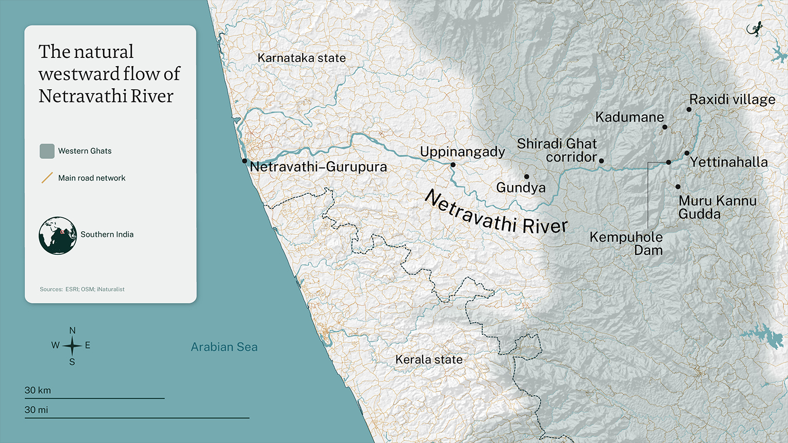
One such mountain is Muru Kannu Gudda, or Three-Eyed Hill, more than 1,100 meters (3,900 feet) above mean sea level in Sakleshpur taluk (administrative division) in the heart of Karnataka’s Western Ghats, about 200 kilometers (125 miles) from Bengaluru, the capital city of the southern Indian state.
“This is where the Yettinahalla is born,” said Prasad Raxidi, a writer, theater person and longtime resident of Raxidi, as he pointed to the longshot view of Muru Kannu Gudda from atop an amphitheater he built with the villagers.
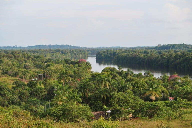
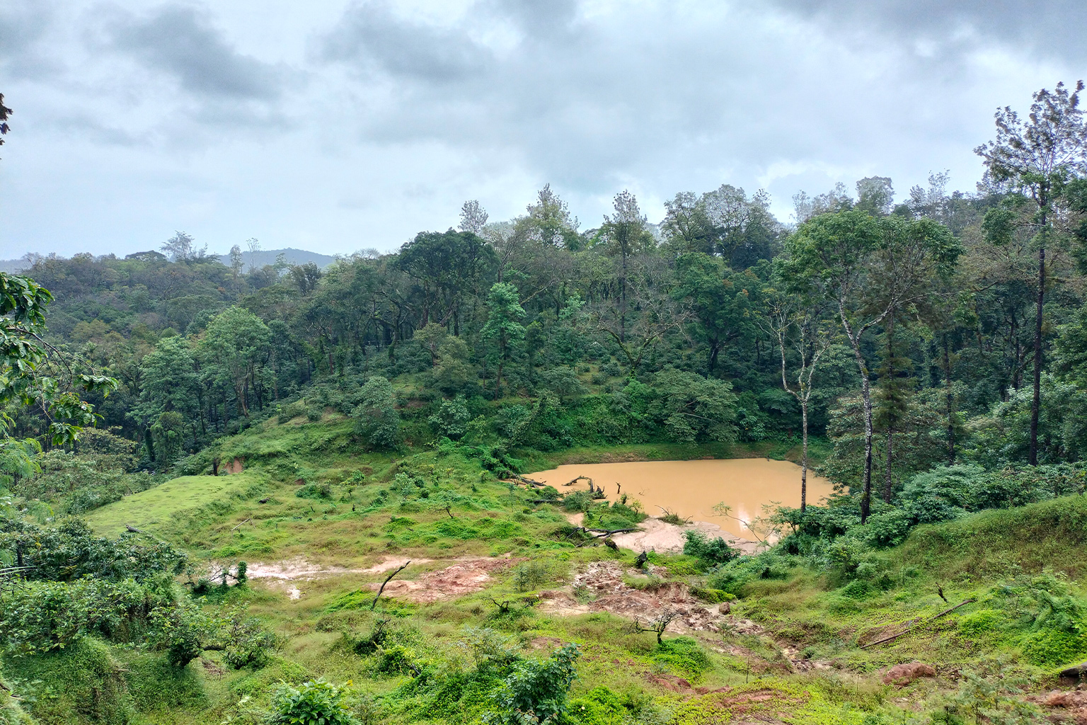
In the foothills of Muru Kannu Gudda, the Yettinahalla streams downward, flowing westward — more a road-wide torrent than a river.
“We swam here during our summer vacations, growing up,” Prasad said. “But they’ve done irreversible damage to it,” he continued, referring to the state government.
The Yettinahalla and several other west-flowing streams feed the Gundia River Basin, in a series of waterways that merge with the Netravathi River as it drains into the Arabian Sea and serves as the major water source for the port city of Mangaluru. Known for its steep hairpin bends and dense evergreen Shola forests, the Gundia River Basin is central to the Western Ghats, harboring nearly 36% of plant species, 87% of amphibians and 41% of fishes that are endemic to the mountain range. Western Ghats is recognized as one of the world’s eight hottest hotpots of biodiversity, extending from the southern tip of India in Tamil Nadu, to Gujarat, bordering the end of Indian west coast. This mountain range is the birthplace to several perennial rivers, forming a key watershed for the entire peninsular India.
But today, things are looking a little different than in the past.
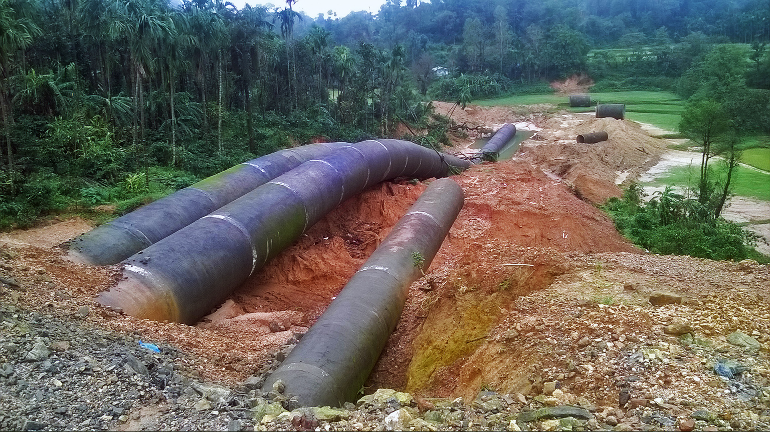
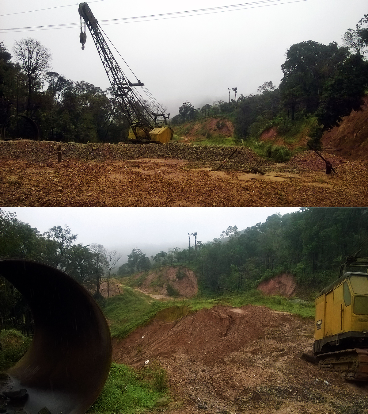
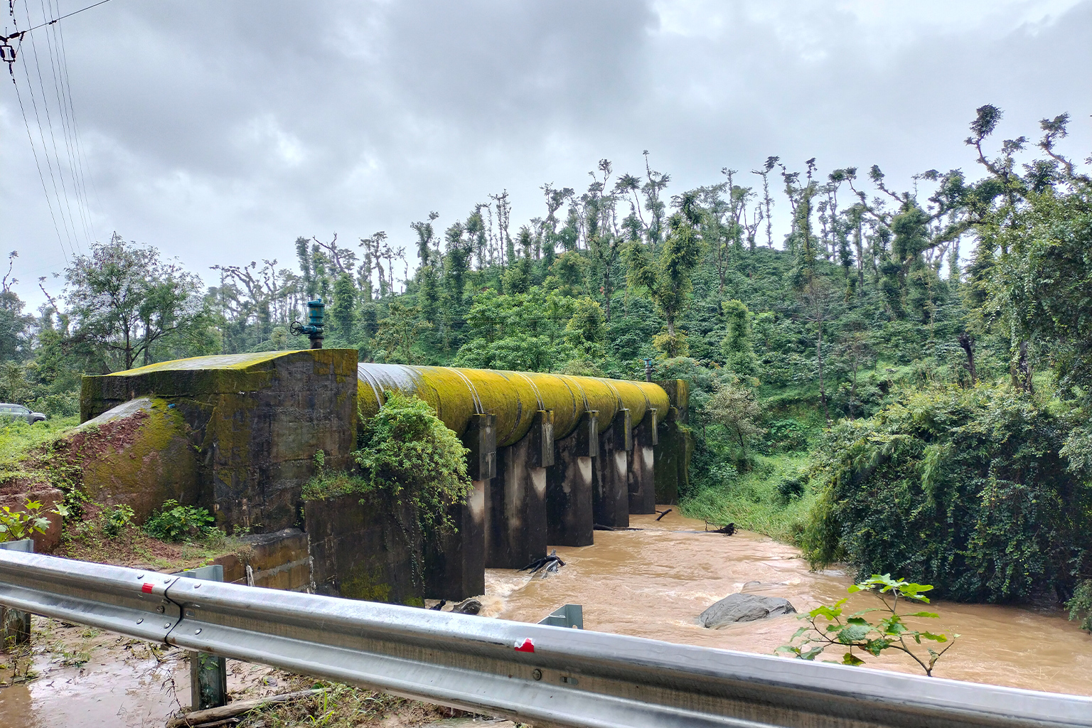
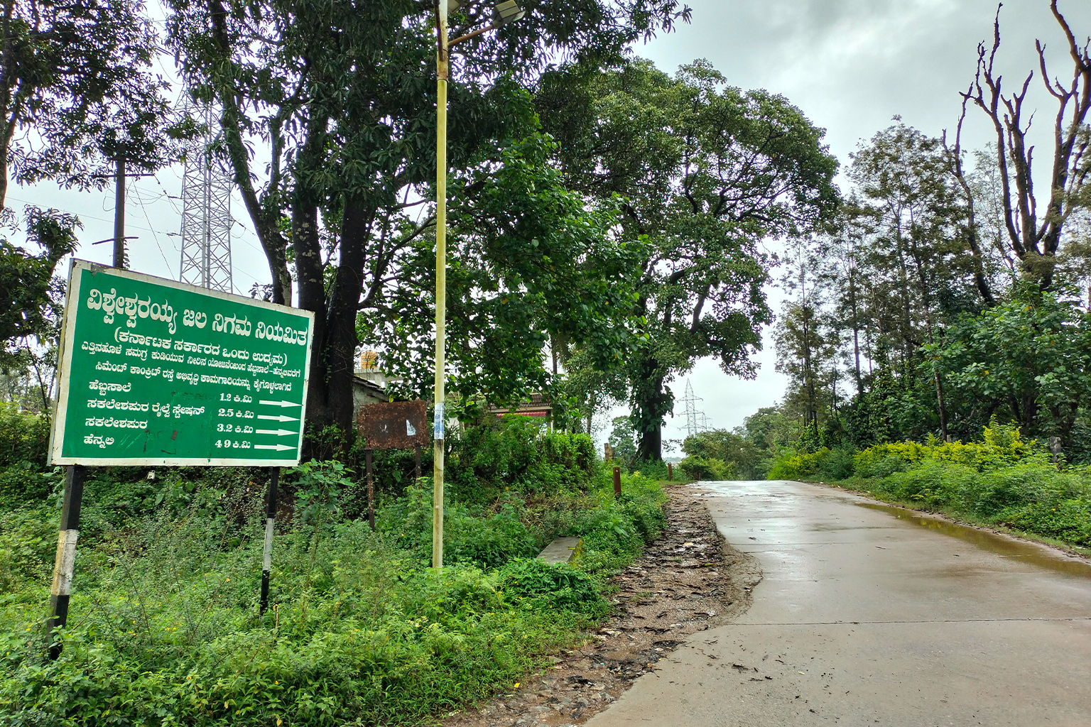
Upstream, villages surrounding Raxidi have concrete canals that carve into hillsides and pipelines that pierce loose soil, to lift the west-flowing Yettinahalla eastward. Tall transmission towers march alongside the pipelines wide enough for a car to drive through. This is the Yettinaholé Integrated Drinking Water Supply Project, an undertaking devised by the Karnataka state government, to provide drinking water to parts of nine dry districts in Karnataka’s east. A project that reimagined streams as rivers, renaming Yettinahalla as Yettinaholé.
What is the Yettinaholé project?
In the local Kannada language, halla means stream, and holé means river. The Yettinaholé project, which was proposed by the Karnataka government in 2012 and approved by the successive government in 2014, aims to divert 24 TMC of stormwater from the Yettinahalla and nearby streams in Sakleshpur taluk to parched districts up to 200 km (125 mi) away to fill more than 500 tanks. The overall cost of the project is $2.6 billion, or more, as work is still ongoing.
The project was planned in two phases, across the construction of eight weirs. In order to transport water from these diversion weirs to the dry districts, the government employed pipelines and gravity canals. This project was initially directed as an “irrigation project” but was later deemed a “drinking water project” across an overall catchment area of 176.7 square kilometers (68.2 square miles).
However, there is an evident mistrust and skepticism surrounding the project’s sustainability. More than a decade down the road, villagers still wonder: How can they divert this small stream so far away? After all, the project conceives lifting water not just from the one stream it is named after, but several such streams, which finally drain into the Netravathi River and its tributaries.
The project has remained controversial since its inception due to both ecological concerns and these questions surrounding its viability. According to the 2011 census, the total population of the catchment area was 16,345 — people who depended on Yettinahalla and nearby streams for daily use and farming activities. However, the project, once completed, aims to quench the thirst of 7.5 million people in the parched districts.
Meanwhile, a 2015 flow assessment of the Yettinahalla catchment area by researchers at the Indian Institute of Science (IISc) estimated that the total runoff from the catchment area was less than 9.6 TMC, in contrast with the government’s estimated 24 TMC. The assessment also noted that evergreen forests dominate the catchment (45%), followed by agriculture plantations like coconut and areca nut (30%) and grasslands (24%).
TV Ramachandra, lead researcher of the assessment, said the presence of these thick evergreen forests and grasslands in the catchment are responsible for higher infiltration of water, feeding the perennial streams. “Any anthropogenic activities involving large-scale land cover changes would affect the hydrology of the river basin,” he told Mongabay.
He said research shows the Yettinahalla and its immediate neighboring catchments fall under what’s considered the “Ecological Sensitive Zone 1,” which strictly prohibits developmental activities.
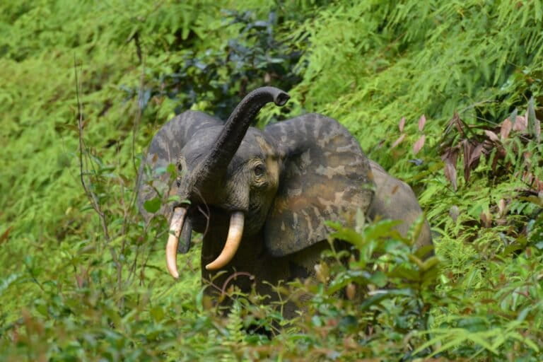
His study also highlighted that the region is vulnerable and prone to frequent human-animal conflicts. Elephants are a keystone species in this territory, along with tigers, leopards and dholes. “Any alterations in the elephant corridors would enhance human animal conflicts threatening the survival of elephants,” the 2015 study mentioned.
And one day, the stream is called a river
The diversion project has spurred a domino effect that is reshaping the culture, economy and ecology of the region.
Villagers in the Yettinahalla catchment area recall that years ago, bamboo rose thick on both sides of the stream, known locally as Yetnalla, the bullock’s stream. Thousands of acres of meadow pasture once surrounded it. Prasad remembers that as cattle grazed, cowherders carved flutes from bamboo and filled the valleys with their music.
“People traveling to Mangaluru in bullock carts would stop and rest here. They’d feed the bullocks and bathe them in the water. That is likely how the Yettinahalla got its name,” Prasad said.
Even now, the village seems quieter on most days, languishing in the flow of numerous streams in the background. But on weekends and holidays, people from nearby cities like Bengaluru flock to resorts and homestays, which are becoming a key business among several of the permanent residents.
Prasad begins his day by measuring daily rainfall, like most of the villagers. He then shares the amount of rainfall on a WhatsApp group consisting of planters in nearby hamlets and coffee-growing districts. Some estates in the region have rainfall data that go back hundreds of years. On average, the region observes an annual rainfall of about 280 centimeters (110 inches). He estimates that in Shola forests uninhabited by humans, the annual rainfall could exceed 380 cm (150 in).
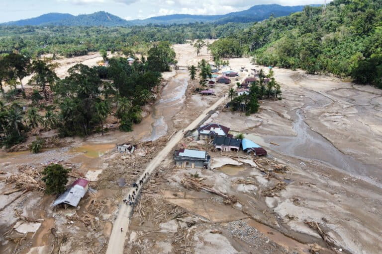
However, through the years, the vast expanse of uninhabited forests thriving on the edge of Sakleshpur has been threatened by talks of development, making this region an epicenter of protests for decades. While most of the bigger projects subsided, developmental activities like the construction of railways and mini hydroelectric power projects have dramatically altered the forest ecosystem, wildlife corridors and hydrology of the rivers. Landslides have become a commonplace occurrence.
And, of course, the diversion project.
“The problem with the Yettinaholé [project] is that they are lobbying on this by calling it a drinking water project, undermining its ecological impact,” said HA Kishor Kumar, advocate and president of a civic group Malenadu Janapara Horata Samiti. Along with the Yettinahalla, the government intends to divert three other streams (Kadumanehalla, Kerihalla and Hongadahalla), which, he said, may entirely affect farming activities in several surrounding villages.
This comes after decades of varying proposals for tampering with the Yettinahalla, which were always met with protests and shelved plans, followed again by renewed plans.
“After strong resistance for decades, we thought they’ll finally leave the ghats alone. But they didn’t,” Kishor said. “We’re tired of fighting now,” he added.
The Detailed Project Report (DPR) of the Yettinaholé project highlights diverting stormwater in the monsoon season, for “drinking water purposes” only, and not irrigation. However, according to the DPR, the lifted water will be stored in both drinking water and irrigation tanks in the dry districts, further raising concerns on the use of diverted water. The project is now being carried out by Visvesvaraya Jala Nigam Ltd., a company controlled by the Karnataka government.
The project received a go-ahead from the National Green Tribunal in 2019. This was despite a “first information report” known as FIR filed by the Forest Department against the executive engineer in charge of the project for alleged use of forest land for non-forest purposes without a mandatory approval from the central government called a “forest clearance.” In April 2025, the Ministry of Environment, Forest and Climate Change noted serious violations, unauthorized use of forest land and environmental mismanagement by the Karnataka state government for the Yettinaholé project. A ministry report stated that of the 70 hectares (173 acres) of forest land in the project area, 44 hectares (108 acres) of forests were used without mandatory forest clearance as per the Forest (Conservation) Act, 1980.
Anand HS, VJNL chief engineer for the Yettinaholé project, confirmed with Mongabay that the forest lands were used without the mandatory approval from the ministry. However, he reiterated that these were not “willful violations.”
“In the records that we examined during project related constructions, we acquired some land from the farmers in the region as records said these were revenue lands. We did not know at the moment that the land belonged to the forest,” he said.
“We’ve agreed to committing all the violations cited by the ministry,” he said, adding, “but this is a very ambitious and one-of-a-kind project.”
Anand said that VJNL has halted construction works since 2022 and is now undertaking the mandatory forest clearance from the central ministry. “Undoing all the work in these forest lands will do more harm than good. Hence, we resorted to making structural modifications in some places under common ground,” he said. The VJNL had not received the required forest clearance by the time of publication.
Meanwhile, Kishor said he fears that as the Yettinahalla and nearby streams are too small to be diverted to places farther away, the government might end up adding one stream after another, finally targeting the Netravathi River itself.
He said successive governments, regardless of party or ideology, have been equally responsible for pushing the Yettinaholé project forward. To him, resistance often felt like a performance staged in parallel, in which those in power wrote the script. “They brought in groups who called themselves activists, who would shout slogans for a week and then vanish,” he said. “We began to suspect these were fake activist groups, planted to make it appear as though dissent was alive, while the real concerns were buried under the noise.”
Environmentalists who questioned the project’s ecological basis or demanded transparency were frequently ignored, sometimes branded as anti-development or “outsiders.” For Kishor, Prasad and others contacted by Mongabay who had given years to the cause, the sense of betrayal was sharp. It was not just governments, Kishor felt, but a whole machinery of contractors, bureaucrats and intermediaries who kept the project alive while systematically weakening the ones who opposed it.

Then came the surveyors
For generations, the villagers around the Yettinahalla had seen little change: the same mud roads that led to homes in the middle of “nowhere” and hardly any access to public transport. Then came the surveyors with terrestrial laser scanning equipment on tripods and officials marking land in chalk. The project stirred environmentalists to warn of ecological risks, but it also stirred hope among struggling farmers, small traders and families who saw no end to their uncertainties.
Planter DM Purnesh, who owns one of the largest estates in Sakleshpur, recalled that land values shot up to three or four times the market price when the contractors, representing the state government body, moved in with an “unusual sense of urgency.”
“They didn’t acquire the land. They purchased it,” he said, adding that a “goodwill” amount of more than $3,000 was dispatched to establish authenticity. “The contractor’s men did most of the paperwork. All they needed was the land. Urgently. And the villagers gave it away,” he said.
When a handful of farmers received compensation, others began to place their trust in the authorities seeking to divert the Yettinahalla.
Concrete roads now cut through to areas once considered remote. Many villagers have converted homes into homestays for alternate income. The number of resorts has multiplied, attracting a huge number of tourists from nearby cities. Villagers estimate there could be 3,000 homestays and resorts in Sakleshpur, including those unregistered. Alongside these developments, small-business owners found new locations for timber mining, causing further destruction of what was considered forest.
A decade down the line, old hope is starting to fade in the eyes of villagers. Farmers who gave away an acre find themselves clearing construction debris left behind on the rest of their land. Villagers say landslides now occur with unprecedented frequency, wiping out lakes and farms, forcing stream channels to change their course.
A scenic road that passes through Harley Estate, one of the largest in Sakleshpur, is still in ruins, carrying the pipeline’s scar on loose monsoon soil. The tar road collapsed, caving downward into a huge pond, almost the size of a lake. To this day, the pond remains completely wiped out.
Ramesh, a coffee grower, said he let the pipeline pass through the center of his plantation for “satisfactory” compensation, which led to the construction of a road inside his farm. But now, he finds villagers grazing their cows and tourists encroaching his land, claiming it as a “public place.”
“It’s not in my capacity to chase visitors and their cows away, when they say it’s a public place,” he said, rather disappointedly. When asked if he regrets the choice he made, he had nothing to say. To him, development comes with a cost.
A more serious problem, however, has now crept into the Yettinahalla basin.
Human-elephant conflict
“In the last 30-40 years of being here, I have not seen a single elephant in the surroundings until the last decade. But we all knew they come and go,” said Radhe Raxidi, Prasad’s wife.
For villagers, elephants were creatures of mystery and pride, not of fear and conflict. Prasad remembers how people would weave stories around footprints or broken branches or disappearing bananas — evidence of a nighttime visit — as though the encounter were a badge of honor.
“There were stories about what an elephant would look like, and we would listen in awe,” he said. Radhe interrupted, “These days, it’s the forest guards we hear instead — going around with microphones about elephant movement, asking villagers to stay cautious.”
Hamlets in and around Raxidi have seen elephants breaking into houses, in search of food. A mud wall caved in where an elephant had pushed its way into a kitchen. Rice sacks lay torn open, jackfruit seeds scattered across the floor.
What changed over the decades? Did it all begin with the diversion project?
Prasad attributed these conflicts with wildlife to the river diversion as well as construction of dams and railways, all of which took place as part of the larger developmental activities in the heart of the forests and elephant habitats.
The use of dynamite to blast rocks along Kempuholé in Shiradi Ghat for mini hydel projects and railways left more than just cracks in the stone, unsettling the forest silence. Old migratory routes used by elephants splintered under the din of explosions, construction of tarred roads in thick forests and the rumble of trucks. Herds that once threaded their way through these valleys began to disappear into less disturbed patches, including the Yettinahalla basin.
Prasad said that around the same time, captive elephants that had been legally used in circuses, tourism and temples were let out into the wild when regulations listed them as endangered and banned their exploitation, less than two decades ago. According to him, these elephants wandered into the ghats and mingled with wild herds. He said, when the landscape of elephants was broken due to larger developmental activities in the forest, their movements became more unpredictable.
Now, villagers say, the elephants come late in the night, when human activity is close to null, destroying crops and eating whatever they get, then going back to their hiding places in patches of forests during the day. It is when the elephants encounter human beings during their late-night or early-morning strolls that they attack them or anything they find on the way. According to Prasad, these elephants return, even if relocated.
For years, the Yettinahalla catchment acted as a refuge, where the elephants could rest, feed and move on, leaving no trace of their movement. Signs of a passing presence remained largely unseen. But as canals, pipelines, resorts and homestays pushed deeper into the basin, even this space is closing in.
“They have nowhere to go now,” Radhe said. Prasad added that while there were talks over construction of aane dhaama, or elephant shelters, it was shelved, as movement is crucial to the elephants’ health.
Follow the river to reach the sea
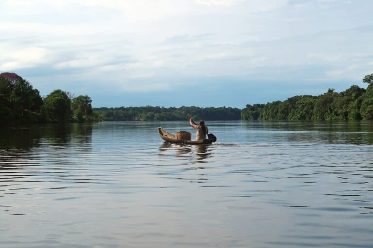
July in Mangaluru, where the rivers meet the sea, is when the fisherfolk meet the rivers. Nobody goes to the sea from June to August or early September, which forms the monsoon season in the region. This period is key to fish breeding in the sea and is dangerous for deep-sea fishing due to strong winds. This is the season of river fish — pricey and special for people, good money for fishers.
Silver biddy and ladyfish hit the market for more than 500-1,000 rupees (about $5.50-$11) per kilogram (2.2 pounds) along with crabs and prawns.
“But this year is not good for us,” said Harish Putran, president of an association of river fishers in Mangaluru. “Fish need the rivers to flood. This year, the rivers were leaner despite heavy rains,” he said.
Mangaluru fishers largely depend on the Netravathi, for its volume and health due to widespread sand mining and industry discharge in other rivers. Referring to another river in the city, he said, “The Phalguni River is almost unusable for fishermen. Fish kills are very common here. The Netravathi is our lifeline.” Putran said at least 800 fisherfolk families in Mangaluru rely on the river for their livelihood.
“If they start targeting streams on the downside, like Kempuholé or Kumaradhara for diversion, we will all suffer,” he said. “We might as well be homeless and become one with the sea.”
In a trial run conducted by VJNL backed by the Karnataka government in 2024, the Yettinaholé project had a disappointing start. In an attempt to transport 5 TMC of water to a dam in Chitradurga district in Karnataka’s east, the state government managed to pump a mere 2 TMC of water and wasted an equal amount. Despite this, the government promises to complete the project by March 2027.
Anand, the VJNL chief engineer, noted that they have installed real-time sensors called telemetry to measure stormwater in the monsoons. “However, we have realized that there may be a shortfall of stormwater in case of reduced rainfall,” he said. He added that floodwater from downstream sub-tributaries of Kumaradhara will be lifted in case of shortage of water in the current weirs.
Villagers in the Kempuholé region have started to notice surveyors, causing tensions to simmer once again, Kishor told Mongabay. “The sub-tributaries they are planning to include for augmentation purposes could be Kempuholé and the streams that ultimately meet the Gundia River,” Prasad anticipated.
For now, the Netravathi flows on. But the question lingers: How much of the river’s journey is its own?
Banner image: A fisher mends his net at the Yettinahalla. Image by Siddarth Machado via Flickr (CC BY-NC 2.0).
Specter of dams and diversion looms over Southeast Asia’s Salween River