- The Strategic Environmental Assessment (SEA) was conceived to broaden Environmental Impacts Assessments and consider long-term, indirect and cumulative impacts, as well as alternative development scenarios.
- In the early 2000s, these SEAs generated a great deal of interest and were applied to several high-profile projects in the Amazon.
- Beyond looking at impacts, they evaluated impacts on forests, the expansion of secondary roads, potential real estate speculation, agriculture and deforestation and how they would affect biodiversity and livelihoods.
In the late 1990s, academics developed a variant of the environmental impact assessment (EIA) methodology known as a strategic environmental assessment (SEA). Originally conceived as a super-EIA, the scope of the analysis was broadened to consider long-term, indirect and cumulative impacts, as well as alternative development scenarios. Key to the SEA methodology is the participation of all stakeholders in open dialogue while multiple development options are still on the table. Over time, EIAs have become formalized as a narrow pathway for mitigating the environmental and social liabilities of a specific project. In contrast, SEAs have evolved in the other direction and now are promoted as a strategic planning process that seeks to maximize the positive outcomes from higher-level policies, plans and programmes.
There was a flurry of interest in SEAs at the turn of the millennium, and the methodology was applied in several high-profile projects in the Pan Amazon.
- Strategic Environmental Assessment for the Bi-Oceanic Corridor, a highway linking Santa Cruz, Bolivia, and Corumbá, Brazil, which connected the transportation networks of the Central Andes with Southern Brazil, an early-stage IIRSA priority built between 2000 and 2012.
- The Plan for a Sustainable BR-163: a Brazilian government initiative to promote sustainable development on the landscapes surrounding the highway between Cuiabá (MT) and Santarém (PA). This highway was originally opened in the 1970s during Operação Amazônia and the segment traversing Pará was essentially abandoned until the early 2000s, when it became an export corridor for soy and corn. Improvements to the highway began around 2002 and are ongoing.
- The MAP (Madre de Dios (Perú), Acre (Brasil) and Pando (Bolivia) Initiative: a tri-national initiative to promote sustainable development in three neighbouring sub-national jurisdictions: The goal was to manage the impacts when regional highway systems were integrated to create the Corredor Interoceánico del Sur. Construction started in 2004 and was completed in 2011.
All three initiatives are examples of an SEA functioning as a super-EIA. Most attention was focused on highway corridors, but instead of an impact area defined by a right-of-way measuring hundreds of metres, these studies sought to understand how change would affect hundreds of thousands of hectares of forest. They modelled the expansion of secondary road networks, land speculation, agriculture and deforestation, as well as how those changes would impact biodiversity and livelihoods. They convened local and regional meetings and workshops to inform all relevant stakeholders and ensure their aspirations were adequately addressed in the environmental action plan.
The motivation for convening an SEA differed in each project. The Bi-Oceanic Corridor was imposed by the financiers on the Bolivian government, who viewed it as an obstacle to their decades-long aspiration for a modern highway to Brazil. The plan for a Sustainable BR-163 was a top-down effort organized by academics and specialists in Belém and Brasília, who were seeking solutions to the phenomenally high rates of deforestation in Mato Grosso and Pará. In contrast, MAP was a bottom-up effort organized by regional governments and civic organizations in Rio Branco (Acre), Cobija (Pando) and Puerto Maldonado (Madre de Dios), whose goal was sustainable economic growth.
It is difficult to evaluate the effectiveness of these pioneer SEAs. All three landscapes subsequently suffered deforestation, forest fragmentation and the loss of biodiversity, largely because conventional development paradigms were already firmly established. Artisanal gold mining was booming in Madre de Dios and the upper Tapajós watershed. Settlers had colonized the landscapes along highways in Madre de Dios, Acre and Pando. Land values were soaring as commercial farmers expanded soy cultivation in Santa Cruz and Mato Grosso.
Unfortunately, none of the SEAs made significant headway in promoting sustainable production models that meaningfully diversified regional economies, with the possible exception of the nascent tourist industries on the Tambopata River (Madre de Dios) and the Serranía de Santiago (Santa Cruz – Bolivia). Fortunately, all three SEAs were able to leverage popular support with limited financial resources to consolidate new protected areas, delineate Indigenous lands and create extractive reserves.
There have been reversals. For example, in 2017 the Brazilian government transferred approximately 305,000 hectares (about 753,670 acres) from the Floresta Nacional (FLONA) Jamanxim, created in 2006, to the newly created Área de Proteção Ambiental (APA) Jamanxim. Both categories (FLONA and APA) are zoned for sustainable use, but there are distinct management and tenure regimes. First, mining is allowed in an APA and not in a FLONA; thus, the change will benefit the owners of dozens of mining concessions.
More importantly, a FLONA is composed entirely of public lands, while an APA can contain both public and private lands. This opens the door for legalizing land tenure for recent settlers in the municipality of Novo Progresso, which has been the object of nonstop land grabbing over the last decade (see above). At least fifty per cent of the deforestation in Novo Progresso occurred after 2010, as evidenced by the number of properties registered in the CAR, which increased from 35 to 352. Landholdings inside a FLONA can never be certified by INCRA, but if the settler can show that a landholding within an APA was established via a legitimate pathway, then INCRA can issue a legal title. Since the history of land titles is unorganised and riddled with fraud, this loophole exposes most APAs to settlement and deforestation.
This is one of Brazil’s most active agricultural frontiers, and most residents of Novo Progresso support the change in status of the protected area. The decision can be viewed from two perspectives: environmental advocates argue that it promotes an endless cycle of land grabbing and legal fraud, while settlers counter that a FLONA was created without adequate local consultation and after the area was already penetrated with numerous secondary roads.
In 2020, an influential think-tank in Brazil suggested that the Brazilian state adopt rules that force the federal government to create a new stage in the planning process specifically for large-scale infrastructure projects. A pre-feasibility evaluation would act as a high-level filter to ensure that only projects that meet certain economic, social and environmental criteria would be allowed to proceed to a formal feasibility analysis. The goal would be to avoid the vested interests and sunk costs that make the subsequent abandonment of the project politically unfeasible.
Peru embraces the SEA – with limited results
The concepts that are the foundation of the SEA methodology have changed how EIAs are conducted, as well as the strategic planning methodologies used by companies, governments and multilateral institutions (see ZEE in Chapter 4). Peru, however, has gone a step further and integrated the SEA into its regulatory framework. The country first established criteria for conducting an SEA in the Environmental Law of 2005, which states that ‘projects’ and ‘programs, plans and policies’ must be reviewed by the National Environmental Impact Assessment System. This was clarified in 2008 to specify that projects would be evaluated by an EIA, while ‘sectoral, regional and local programmes, plans and policies’ would require an SEA.
By 2011, the concept of an SEA had been widely disseminated and tested in selected initiatives, including highway infrastructure, oil and gas, energy policy and tourism. The influence of those SEAs is difficult to discern, and almost all were conducted post hoc – after the ‘plan, programme or policy’ had been developed. The SEA for the Corredor Interoceánico del Sur was essentially an extension of the MAP initiative and was conducted as the highway was under construction.
Likewise, the study for the Lower Urubamba was conducted long after the decision had been made to develop the Camisea gas fields. It may have helped the Cusco regional government understand changes that were already underway, but there is no evidence that any of the eighteen specific project proposals recommended by the SEA were ever funded or implemented. The SEA for the national energy sector was entirely conventional and emphasized the potential of gas and large-scale hydropower. This is unfortunate, given the massive potential of solar energy on the coast and the potential complementarity among hydro, wind and solar in an integrated system. Similarly, there was no effort to consider the impacts of large-scale hydropower on the hydrology of Amazonian tributaries, which should be an obvious issue in a strategic environmental analysis.
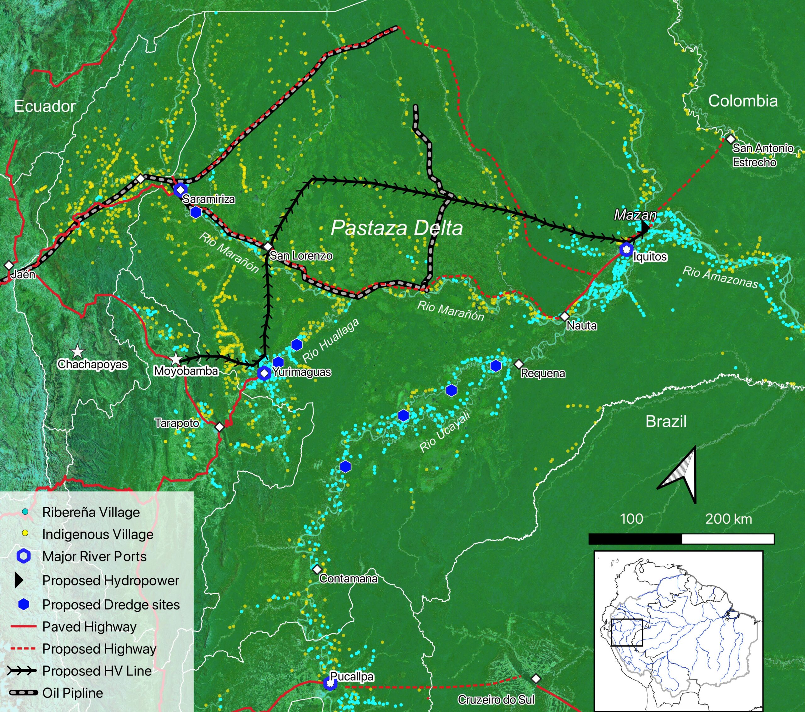
The most recent application of the SEA has been a development plan sponsored by the regional government of Loreto in collaboration with the civil society organisation Derecho, Ambiente y Recursos Naturales (DAR). The Plan de Desarrollo Regional Concertado 2008–2021 was updated in 2011, before the collaboration with DAR, and again in 2014. The plan has many admirable features, including ambitious goals for investment in education and health services, improvement of administrative systems, promotion of economic diversification and support for natural resource management. The Loreto SEA also envisions the development of several controversial infrastructure projects, including a high-tension line to connect Iquitos to the national grid and a run-of-river hydropower facility on the main stem of the Amazon. Both projects were eventually abandoned when SENACE rejected their EIAs.
The most contentious projects are proposals to build regional highways through forest wilderness between (1) Iquitos and the Putumayo River – the proverbial road to nowhere; and (2) Iquitos and the Ecuadorian border, to connect with the right-of-way of the existing Northern Peruvian Oil Pipeline and the national road network at Saramiriza. Unfortunately, the SEA for Loreto does not seem to have eliminated several projects that do not meet accepted environmental, social and economic standards. Evidence for the recalcitrance of local elected officials and their administrative staff is manifest by the recent congressional resolution declaring construction of the Iquitos – Samariza highway a national priority.
Fortunately, this type of law is aspirational and does not place the highway project in the national budget or exempt it from a formal EIA. It vividly demonstrates, however, that the SEA process in Peru can be manipulated or ignored by policymakers. It also highlights the challenge of engaging regional leaders in sustainable strategies, because many have very conventional perspectives on economic development.
Colombia has a similar process, known as Evaluación Ambiental Estratégica Regional (EAER), which the environment ministry and two civil society organisations used to prepare a long-range planning document for the Arco Noroccidental Amazónico (ANA), which encompasses the most active deforestation frontier in the northern Amazon. The study enlisted the active participation of strategic regional, sectoral and national stakeholders and provided a coherent diagnosis of the many challenges that beset the region after the end of a long civil war. Nonetheless, its proposed policy options have not been successful in changing the arc of development (and deforestation) in the region, because the state has failed to establish its presence in a way that might force or motivate individuals to change their behaviour and business models.
Banner image: Toco toucan (Ramphastos toco) from Brazil. Image by Rhett Butler.