- Mongabay is publishing a new edition of the book, “A Perfect Storm in the Amazon,” in short installments and in three languages: Spanish, English and Portuguese.
- Author Timothy J. Killeen is an academic and expert who, since the 1980s, has studied the rainforests of Brazil and Bolivia, where he lived for more than 35 years.
- Chronicling the efforts of nine Amazonian countries to curb deforestation, this edition provides an overview of the topics most relevant to the conservation of the region’s biodiversity, ecosystem services and Indigenous cultures, as well as a description of the conventional and sustainable development models that are vying for space within the regional economy.
- Click the “A Perfect Storm in the Amazon” link atop this page to see chapters 1-13 as they are published during 2023 and 2024.
The sharecropping system that defined land tenure in the Ecuadorian highlands prior to agrarian reform was known as the ‘huasipungo’, a Quechua word that describes the relationship between landlords and tenant farmers. The end of this feudal system had a radically different outcome when compared to Peru and Bolivia, however, because landowners preempted the confiscation of their lands by expelling tenant farmers. Owners mechanised farm operations and turned to contract labour, while thousands of peasant families were evicted from their homes. Some moved to urban centres, but many chose to migrate to the agricultural frontiers in the tropical lowlands of the Amazon and the Pacific coast.
The official effort to promote settlements in the Ecuadorian Amazon began in 1957 when the democratically elected government created the Instituto Nacional de Colonización (INC). In 1964, a military government enacted the Ley de Reforma Agraria y Colonización, which merged the INC into the newly created Instituto Ecuatoriano de Reforma Agraria y Colonización (IERAC). Between 1964 and 1994, IERAC distributed about five million hectares (12.35 million acres) of land with support from USAID and the Alliance for Progress; about 1.8 million hectares (4.45 million acres) were located in the five Amazonian provinces. Land was distributed in forty-hectare plots, which suggests that about 45,000 families acquired plots in the Amazon during this 30-year period.

Unfortunately, the IERAC did not provide homesteaders with documents that were equivalent to a legal title because ownership was contingent upon residency and evidence of development. Settlers were provided with a provisional deed that required future administrative action to be converted into a full legal title. The IERAC did not incorporate this information in a national archive; instead, the information was preserved in ‘folders’ housed at their regional offices.
In 1994, a new law replaced IERAC with the Instituto Nacional de Desarrollo Agrario (INDA), and, as in Peru and Bolivia, a major objective was to introduce market economics into the rural economy as part of ‘structural readjustment’ policies. The law centralized the land titling process in Quito and in 2002 was supported by an IDB-financed initiative to create a digital database. This initiative had only limited success, however, and by 2010 a total of 700,000 ‘folders’ were waiting to be processed when INDA was dissolved and its functions were transferred to the Subsecretaria para Tierras y la Reforma Agraria at the Ministry for Agriculture.
The responsibilities of the new agency had been fundamentally changed, however, because the constitution of 2008 devolved administrative authority over land tenure back to municipal governments. Nonetheless, the law tasked the national government with the responsibility of compiling and maintaining a digital database, which led to the creation of a national cadaster known as SIGTIERRAS. The IDB supported the effort with another loan that incorporated the experiences of the previous decade’s pilot project.
The land tenure process is now managed by the Autoridad Agraria Nacional (AAN), a new entity with an expanded portfolio of obligations that was created by the Ley de Tierras of 2016. This far-reaching legislative act seeks to ameliorate inequality of land tenure in Ecuador and establishes limits on the maximum dimensions for properties: 200 hectares (494 acres) for the highlands, 500 hectares (1235.53 acres) for the coast and 1,000 hectares (2471.05 acres) for the Amazon. It also provides the ANN with the power to confiscate properties that are larger than these dimensions or do not meet criteria regarding social and economic function. In spite of its populist appeal, the land law generated criticism because it did not incorporate specific protocols for resolving the claims of lowland indigenous communities.
Although their territorial rights are enshrined in the constitution and codified by the Ley de Tierras, there are only a handful of fully demarcated Indigenous entities. As in other countries, these can be organized into two broad categories: communal landholdings associated with one (or a few) villages on frontier landscapes and large reserves extending across wilderness landscapes with several isolated villages. The Indigenous territories shown in maps prepared by civil society organizations show both types of tenure categories. Most territories have been established by presidential decree, but only a few of the village landholdings have been formalized and demarcated. Most represent claims presented to the government. Their final size and exact boundaries are awaiting the land tenure review process that has been underway for at least two decades.
As in Peru and Brazil, the land regularization (saneamiento) process in Ecuador is being organized using field campaigns that target specific municipalities in order to maximize the participation of property owners and achieve wall-to-wall coverage. As of October 2017, the AAN had registered 1.4 million rural properties in 59 municipalities, a significant number but only a fraction of those were awaiting regularization in the nation’s 221 municipalities. Incomplete as it may be, this number dramatically overturns previous estimates about the number, size and distribution of rural properties in the country.
The agricultural census of 2000 enumerated a total of 850,000 Unidades de Producción Agropecuaria and reported that about seventy per cent had obtained legal titles. Although they are more than twenty years old, these statistics have been reproduced in subsequent reports and used to guide policy. Preliminary results from the IDB pilot project registered about 2.7 million parcels and suggested that about sixty per cent were lacking secure titles.
The results from the second IDB project would place the number of landholdings between four and five million. The most recent survey found that ~75% of the landholders hold some kind of legal document that supports their possession, although fewer than a quarter of them had registered their property with regional land offices.
The regularization process, which has been carried out in three of 41 municipalities in the Ecuadorian Amazon, likewise shows that previous assumptions underestimate their number and overestimate their dimension. For example, the number of landholdings registered in a single municipality was greater than the number reported by the census for the entire province. The discrepancy may be caused, in part, by an expansion of the agricultural frontier; however, most of the difference can be explained by the subdivision of existing properties.
The original distribution in the 1970s averaged between forty and sixty hectares; in contrast, the predios registered in SIGTIERRAS averaged between ten and twenty hectares, indicating that many have been legally subdivided, probably via inheritance, into smaller units.
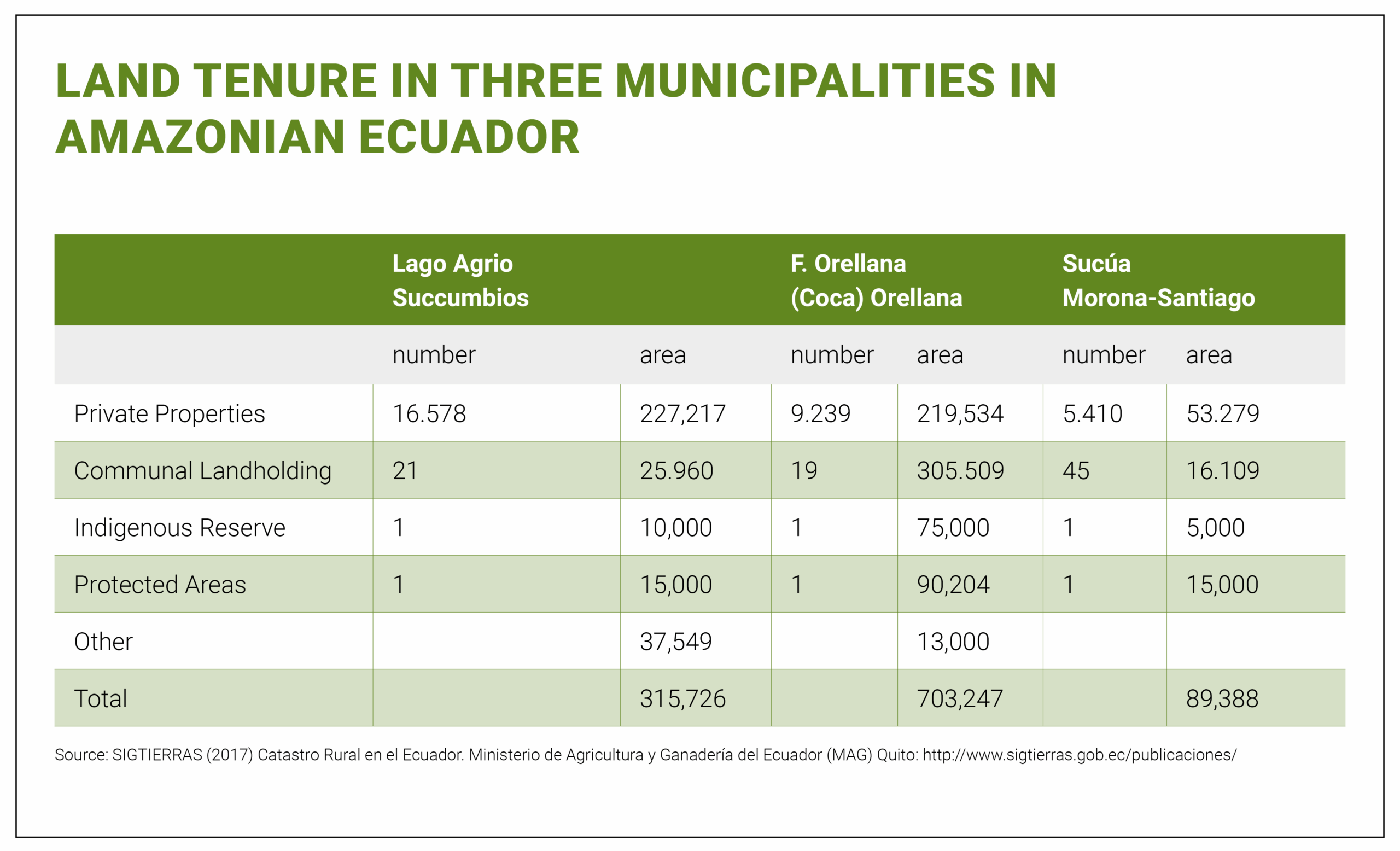
The census of 2000 reported a total of 46,000 farmsteads in Amazonian Ecuador covering a total of 2.5 million hectares (6.17 million acres), about 27% of the total area. Nonetheless, the total area identified as human modified landscapes spans approximately 3.9 million hectares (9.64 million acres). Assuming the mean size of a private landholding lies between twenty and forty hectares, then there should be between 75,000 and 150,000 landholdings that need to be registered, validated and incorporated into SIGTIERRAS.
The resolution of Indigenous lands is likewise unfinished. Their claims for communal landholdings sum to ~2.5 million hectares (about 6.17 million acres) distributed across more than 4,000 communal landholdings. Only 85 have actually been demarcated and issued a legal title, all within the three municipalities that benefitted from the SIGTIERRAS project, which confirmed that indigenous claims often overlap with private properties. This was particularly the case in Morona-Santiago, where Shuar families have laid claim to individual landholdings using the legal options available to them in the decades before the state started recognizing communal landholdings.
The state has the infrastructure in place to resolve this long-standing administrative obligation to its rural citizens. The ANN has offices in all five provincial capitals and an online application where property owners can self-register their landholdings. Hopefully, the IDB will finance a third phase of the SIGTIERRAS project that will allow the government to complete the task.
Banner image: Balsa wood drying facility in the Amazon. Image by Rhett A. Butler/Mongabay.
“A Perfect Storm in the Amazon” is a book by Timothy Killeen and contains the author’s viewpoints and analysis. The second edition was published by The White Horse in 2021, under the terms of a Creative Commons license (CC BY 4.0 license).
Read the other excerpted portions of chapter 4 here:

Chapter 4. Land: The ultimate commodity
- Land in the Pan Amazon, the ultimate commodity: Chapter 4 of “A Perfect Storm in the Amazon” January 9, 2024
- Obtaining a certified legal title in the Pan Amazon January 11, 2024
- The dynamics of violence in pursuit of land in the Pan Amazon January 17, 2024
- Agrarian reform agencies and national land registry systems in the Pan Amazon January 18, 2024
- INCRA as a regulatory agency January 25th, 2024
- Terra Legal program to regularize small property owners January 25th, 2024
- How Bolivia pioneered agrarian reform in South America February 1st, 2024
- A coalition created by a demand for land is splintered by a competition for territory February 1st, 2024
- How to achieve the regularization of rural land in private properties in Peru? February 6th, 2024
- A particular agrarian reform process in Peru February 8th, 2024
- The creation of settlements in the Ecuadorian Amazon February 13th, 2024
- Land distribution in Colombia, Venezuela and Guyana February 14th, 2024
- Land use planning helps advance conservation in Brazil February 21th, 2024
- Low implementation of land use maps in Andean countries affects conservation outcomes and agricultural productivity February 22th, 2024
- Ecuador, Colombia and the Guiana Shield join the planning of sustainable land use February 28th, 2024
- In the Amazon, what happens to undesignated public lands? February 29th, 2024
- What is most convenient in land distribution? March 5th, 2024
- Land irrigation as an obstacle to agricultural intensification in Mato Grosso March 6th, 2024
To read earlier chapters of the book, find Chapter One here, Chapter Two here, and Three is here.


