- Between August and September 1,300 hectares (3212 acres) of forest land in Ankarafantsika National Park in northwestern Madagascar was burnt.
- Bush fires from slash-and-burn cultivation, in which forestland is burnt and cleared to plant crops, caused the most damage.
- The fires impacted forests not just in the buffer zone of the park but also the core area.
- The Malagasy government has called on the international community to aid its fire-fighting efforts.
Fires razed more than 1,300 hectares (3,200 acres) of forestland in Madagascar’s Ankarafantsika National Park in August and September — four times the size of New York City’s Central Park.
By now, the worst appears to be over, an official said. “Currently, there are some fire points around the park, and the field team works closely with the local force (armed forces, local population, firefighter, regional and municipal administration) to extinguish them,” Mamy Rakotoarijaona, director-general of park operator Madagascar National Parks (MNP), told Mongabay in an email on Oct. 8. “We can say that the fire is mastered; on the other hand, caution is in order.”
The park, in northwestern Madagascar, is home to the country’s fast-disappearing dry deciduous forests. Less than 5 percent of the country’s original dry forests survive today. The park also includes swamp forests and riparian forests that adjoin water bodies.
The forests of Ankarafantsika support a marvelous array of life: about 850 plant species, more than 85 percent of which are endemic to Madagascar and 16 species of which are endemic to the park; more than140 bird species, and eight lemur species.
The national park was established in 2002 by stitching together three existing reserves, spread across 130,000 hectares (321,000 acres), that have held protected status since the early 1900s.
However, official protection has not shielded the park from the recurring threat of human-caused bushfires. Slash-and-burn agriculture is practiced widely in Madagascar and is a major driver of deforestation. People burn and clear forestland to plant crops before the start of the rainy season that runs from November to April. The fires appear in July and intensify around October.
“Every year, around 120,000 hectares [297,000 acres] of forest disappear, mostly as a result of slash-and-burn farming,” Alexandre Georget, Madagascar’s environment minister, told Deutsche Welle, Germany’s international broadcaster. “If the destruction continues at this rate, Madagascar will be completely deforested in 40 years.”

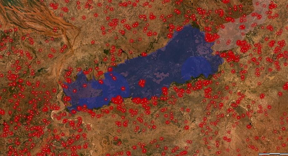
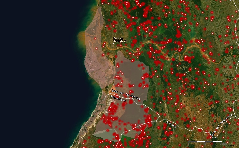
NASA fire maps from this year’s dry season show the island blanketed in angry red spots where blazes burn, including all around Ankarafantsika National Park. There, strong winds push fires located near the boundary into the protected area. The September fires burned forests in the buffer zone of the park, a savanna and forest landscape that’s popular with tourists. Maps from NASA and MNP show that fires also destroyed forests inside the core protected area.
Local authorities said that efforts to raise awareness among villagers and provide alternatives to unsustainable agriculture do not appear to be working. “We are raising awareness among the people, but that does not seem very effective,” Ihando Andrianjafy, the regional director of the environment, told RFI, the French public radio station. “What we are trying to do now is to discourage them by explaining that these fires are punishable by imprisonment.”
Since May, the gendarmerie, responsible for civil law enforcement, has arrested 16 people for fire-related offenses, according to local news reports.
The MNP’s Rakotoarijaona said there was an urgent need for fire-fighting equipment, including aircraft to dump water and fire-retarding chemicals, and offroad water tankers.
Securing parks and other protected areas is a major challenge for the country, where fires wipe out biodiversity-rich habitats every year. Another protected area to the south of Ankarafantsika on Madagascar’s west coast, Menabe Antimena, has been devastated by fires. Swelling domestic and international demand for corn and peanuts is compelling locals and migrants from drought-hit southern Madagascar to clear forests both around and deep inside the protected area. A steady influx of migrants has also been increasing pressure on Ankarafantsika.

However, experts like Johanna Eklund from the University of Helsinki, who has researched the effectiveness of protected areas, says that having them is better than offering no protection at all. “Our recent analysis shows that it experiences very high levels of deforestation, yet is successful in mitigating the threats,” she said of Ankarafantsika National Park. “This indicates that without the protected area being established, even more deforestation is likely to have taken place there.”
Even so, the scale of devastation unleashed in the space of just a few weeks has drawn the attention of Madagascar’s national government. At a cabinet meeting on Oct. 2, President Andry Rajoelina said the issue would be taken up at the national level and asked international partners to join the effort. An emergency meeting to discuss the fires in Ankarafantsika was convened the following day between the prime minister, the minister of environment, and other high-ranking government officials. Though public education and awareness continues to be a priority, the prime minister spoke of the need to mobilize security forces to fight the fires.
The government has proposed the implementation of a cross-sectoral policy on fire management and control, developing a national and coordinated approach to the fires.
With fires in the Brazilian Amazon dominating the news in August and early September, Madagascar’s environment minister has called attention to his own country’s struggle with forest fires. “Fighting fires is one of our priorities. We are calling on everyone who can help us, especially European countries,” Georget said in the interview with Deutsche Welle published in September. “We urgently need fire-fighting aircraft because, at the moment, we are unable to react quickly and effectively to fires.”
Banner Image: Fires blaze in Kirindy forest in Menabe Antimena protected area in west Madagascar in this July 2019 photo. Image by Rhett A. Butler.
Malavika Vyawahare is the Madagascar staff writer for Mongabay. Find her on Twitter: @MalavikaVy
FEEDBACK: Use this form to send a message to the author of this post. If you want to post a public comment, you can do that at the bottom of the page.


