Complete map of world forests to help REDD carbon trading initiative
An interview with remote sensing expert Josef Kellndorfer:
Complete map of world forests to help REDD carbon trading initiative
Rhett A. Butler, mongabay.com
February 28, 2008
Policymakers, conservationists and scientists have high hopes that REDD, a mechanism for compensating countries for reducing emissions from deforestation and forest degradation, will spur a massive flow of funds to tropical countries, helping preserve rainforests and delivering economic benefits to impoverished rural communities.
To date, one of the biggest hurdles for the initiative has been establishing a baseline for deforestation rates — in order to compensate countries for “avoided deforestation” it first must be known how much forest the country has been losing on a historical basis. Until now, with some notable exceptions, this data was based largely on spotty satellite assessment and surveys of national forestry departments by the U.N. Food and Agricultural Organization. Given these origins, the accuracy of the data was often called into question: a January study, published in the journal Proceedings of the National Academy of Sciences (PNAS), said the data was wrought with “errors and inconsistencies.” Complicating matters, conventional satellite sensors were frustrated by the cloud cover commonly present in the rainy tropics.
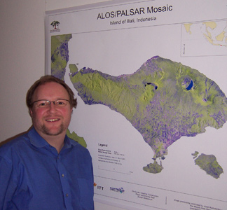 Dr. Josef Kellndorfer in front of an 2007 ALOS image mosaic of the Island of Bali which was presented to the Senator of Bali during the UNFCCC COP 13 meeting. |
Now a new remote sensing satellite, known as ALOS, promises to improve remote assessment of forests, cutting through clouds and possibly even determining measuring the amount of carbon sequestered in a particular tract of forest.
Dr. Josef M. Kellndorfer, an associate scientist at the Woods Hole Research Center in Massachusetts, has worked extensively with radar sensor technology like that found on ALOS and says the satellite captures data that can be used to construct maps of global tropical forest cover on an annual basis. These maps can be used to establish a credible baseline for REDD initiatives.
In February 2008, Kellndorfer spoke with mongabay.com about ALOS and its implications for carbon finance via REDD.
Mongabay: How did you become interested in remote sensing?
Kellndorfer:
Currently I try to find the best tools to monitor natural resources from space. What got me interested in this was, as a child, seeing pictures of Earth from space. It was fascinating and I wanted to see more and more detail.
One of the impediments for me studying remote sensing when I looked at the tropics was the clouds. When I came across a technology — called radar remote sensing — that was capable of penetrating cloud cover, I knew it was something I should look into.
At a seminar in Munich, I met Fawwaz Ulaby, one of the leading radar remote sensing experts in the U.S. In 1994 I went to study with him at the University of Michigan. I spent 10 years at that lab where a lot of pioneering work in remote sensing was done.
Mongabay: How does radar remote sensing penetrate clouds?
Kellndorfer:
Radar is very different from optical remote sensing in two ways. One, it operates in a completely different part of the electromagnetic spectrum, namely in the microwave region — really long wavelengths. It’s because of the long wavelengths that you penetrate the clouds. Whereas with optical, you are dealing with really short wavelengths — in terms of nanometers — whereas microwaves are in the 5, 25, to 40 centimeter range. These really long wavelengths don’t interact with the small particles that form clouds so you can penetrate through them. It’s an active system, meaning a radar sensor has an antenna sending out energy and measuring how much energy bounces back. This differs from an optical satellite sensor where you basically measure reflected sunlight: how much reflected sunlight is visible or how much infrared arrives at a sensor or, in terms of thermal remote sensing, how much thermal emitted energy arrives at the sensor.
What’s also interesting is with that long wavelength you have some penetration capacity into the forest canopy. This makes radar remote sensing particularly suited to detection of the vegetation structure in that it penetrates down to the forest floor or has interaction with branches and tree trunks. This can provide some sensitivity to biomass and flooding. In this sense, it is a very different technology from optical sensing.
Mongabay: Does this mean you can determine what areas have been selectively logged?
Kellndorfer:
That’s the ideal situation — we are in the process to determine what the best approaches are to capture forest degradation, e.g., with respect to what resolution one uses or how technology like radar interferometry and repeat observations will work. But with radar sensors in space now, e.g., on Europe’s Envisat, Canada’s Radarsat 1 and 2, Germany’s TerraSAR-X, and Japan’s ALOS we have a suite of very high resolution radar sensors in place that provide cloud-free data for tropical forest monitoring. Also, there is still a large untapped potential in fusing optical with radar observations
Mongabay: Can you monitor deforestation on a global scale?
Kellndorfer:
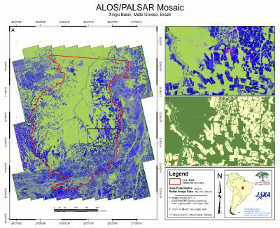 One of the greatest threats to the Amazon rainforest is the rapid expansion of industrial agriculture, and rates of deforestation are likely to increase in the coming decades as demands for biofuel and animal feed increase. Scientists at the Woods Hole Research Center are actively involved in the development of policy mechanisms focused on compensating rainforest nations for slowing deforestation, thereby reducing their emissions from heat-trapping greenhouse gases. As part of this effort, Dr. Josef Kellndorfer and his colleagues are investigating the latest spaceborne remote sensing technologies for monitoring tropical deforestation, including a new Japanese radar sensor, the Phased Array L-Band Synthetic Aperture Radar (PALSAR), carried on board the Advanced Land Observing Satellite. Using data from the ALOS/PALSAR, Dr. Kellndorfer’s group has produced the first-of-its-kind, large-scale, wall-to-wall image mosaic for a portion of the Amazon basin . Launched in 2006, the ALOS/PALSAR will deliver annual pan-tropical image acquisitions over short time frames (~3 months) and through dense cloud cover and precipitation. These characteristics make ALOS data ideally suited for reducing current uncertainties associated with quantifying forest loss and agricultural expansion across the tropics. Credit: Josef Kellndorfer/Wayne Walker, The Woods Hole Research Center (whrc.org) |
Yes. This is why I’m so excited about ALOS. ALOS — the Advanced Land Observation Satellite — is the latest JAXA (Japan Aerospace Exploration Agency) satellite that features three sensors: an optical sensor, a typical multi-spectral sensor with visible and infrared bands; a precise stereo mapper for generation of very high resolution elevation models and topographic information, which is also optical-based; and a radar sensor named PALSAR. The PALSAR sensor proves as a very powerful system ready for deforestation monitoring for two reasons: First it uses the longest wavelength (23 cm — termed L-Band) currently operated from spaceborne platforms, which is particularly powerful in separating forest from deforested areas and also the observation of wetlands and flood dynamics because the long wavelength can also penetrate into the canopy. Second, the Japanese Space Agency JAXA has designed an unprecedented observation strategy which provides for global high-resolution radar data collections within very narrow observation timeframes several times per year. The radar sensor is programmed throughout the ALOS mission to follow this dedicated observation strategy affording the collection of global data sets.
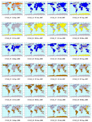 Global observation strategy for various ALOS/PALSAR sensor modes (Source: JAXA/EORC). From New Eyes in the Sky |
Basically we observe at least once a year, at 20 meter resolution, the entire globe: all major biomes. The same sensor, using a different mode, also has a coarser resolution — 100 meters — that provides near-global coverage every six weeks and is now increasingly used to detect illegal logging activities, especially during the rainy and cloudy seasons. This time series is also very useful for flood monitoring. We now have some very beautiful examples of the flood pulse in the Amazon — and can accurately measure and map the floodplain.
These capabilities are exciting because we have the complete pan-tropical forest cover for 2007. We’ll get the same on an annual basis for the life of the ALOS mission. This will enable us to build a data record of forest cover on an annual basis no matter what the cloud conditions are. We can even see through haze and smoke caused by forest fires.
Every year, within three months, we will have a full resolution pan-tropical assessment of forest cover. That of course is very interesting when it comes to the REDD issue. ALOS and future missions with dedicated observation strategies can thus be used as a tool to complement the overall remote sensing and monitoring effort of forests.
Mongabay: So this technology could relegate FAO figures based on forestry surveys in individual countries? FAO data have been widely criticized as being rife with inaccuracies and out-of-date, but until now it was the only source for forest cover statistics. So does this mean that we are going to start to see better numbers?
Kellndorfer:
That’s what we’re trying to accomplish. The first step is getting funding. The second step is converting the data into forest cover maps.
We’re still working on what the limitations of the technology are, for example we are pushing for the direct measurement of woody biomass where we clearly need the synergy with ground surveys and other technology like lidar remote sensing to calibrate the measurements. We know this works better in some areas than in others but at the end of the day we will have annual records of forest cover. These records can certainly help with forest monitoring. This is what is needed for REDD — a reliable, accurate, and objective monitoring capacity that will work in concert with other remote sensing tools.
Mongabay: Is this something that will be around for a decade? Is there concern the sensors will degrade or the satellite will move out of orbit?
Kellndorfer:
The situation is pretty good. From all ALOS assessments we have so far from the calibration and validation, JAXA did an excellent job putting the sensor into the right orbit that there’s very little fuel needed right now for major orbit corrections that they suspect the sensor has a lifetime of at least ten years.
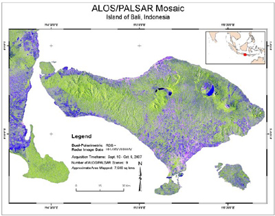 Bali, Indonesia, host to the 2007 UNFCCC Conference of the Parties 13 (COP-13). The radar image mosaic is a composite of nine individual scenes (45,000 km2) acquired by the PALSAR sensor carried on board ALOS. The image acquisitions were made between September 9 and October 10, 2007. From New Eyes in the Sky |
While ALOS has been a great tool and is expected to continue to be for another decade, it should be mentioned that the Brazilian Space Agency is planning to build MAPSAR, which will have the same L-band sensor. JAXA is planning a follow-on sensor now — we, the Kyoto science team, are advising on what are the best parameters and configuration for forest observation — while the U.S. is looking at building a system based on the same technology that will launch in 2015.
As such, my prediction is we’ll have this sort of observation capability from here on out. It will certainly cover the post-Kyoto commitment period from 2013-2017.
Mongabay: If REDD becomes viable it would seem there would be no shortage of funding for this kind of monitoring.
Kellndorfer:
Absolutely. I expect that in an accounting system established to reduce the uncertainties in the REDD carbon market, monitoring will be only a fraction of the cost of what the trading volume will be.
If governments are spending or receiving money for REDD then they should also be willing to fund the monitoring system, which again will be only a small fraction of the overall effort.
Mongabay: If a student wanted to go into this field, do you have any advice for them?
Kellndorfer:
I think the key for anyone who wants to go in the direction of using remote sensing and satellite observation tools for natural resource monitoring, is sharpening his or her math, physics, and computer science skills in addition to having knowledge on the natural resources side. Because the sensors are complex to some degree, it helps to understand the “black box” in order to contribute.
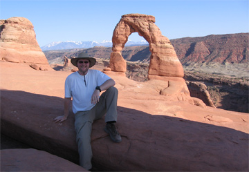 Dr. Josef Kellndorfer taking a break from trees in Arches National Park |
Getting out in the field and interpreting images is really needed as well. It’s very important that one understand the terrain one is looking at.
Every student who really wants to make progress in this should probably acquire some programming skills and be able to understand the tools.
In my eyes it’s really a new era in remote sensing. We can generate large-scale wall-to-all image mosaics from remote sensing data in a very short period of time, pretty soon probably on one’s laptop. It’s been unprecedented that we have the remote sensing capacity to observe forest cover every year and it’s so much better than what we had. ALOS and other radar sensors are definitely a resource that will help meet our needs tremendously.
Related
Josef Kellndorfer (2007). New Eyes in the Sky: Cloud-Free Tropical Forest Monitoring for REDD with the Japanese Advanced Land Observation Satellite (ALOS) [PDF]. The Woods Hole Research Center. United Nations Framework Convention on Climate Change (UNFCCC) Conference of the Parties (COP), Thirteenth session. 3-14 December 2007
Ground-breaking Amazon rainforest imagery will help monitor deforestation
(11/27/2007) Scientists have developed a ground-breaking high resolution snapshot of 400,000 square kilometers of Amazon rainforest. The work will help researchers remotely monitor deforestation, according to the Woods Hole Research Center (WHRC). The researchers say remote sensing systems will play a critical role in the development of REDD (Reduced Emissions from Deforestation and Degradation) mechanisms that seek to compensate tropical forest nations for avoiding and reducing deforestation.


