- Thai researchers incorporating remote-sensing technology into smartphone applications are helping to reduce the severity of forest fires in the country’s northern Chiang Rai province.
- In the past, only local officials had access to hotspot data from satellites; now, whenever a new hotspot is identified, firefighters and nearby communities alike receive notifications on their mobile apps.
- The app has enabled villagers, firefighters, NGOs and scientists to “join forces” in fighting forest fires, and encouraged communities to police and reduce unregulated burning of agricultural land.
- The researchers are currently working on a second app that aims to help local communities transition toward more sustainable ways of clearing and fertilizing their land than burning.
The fire season in Chiang Rai, Thailand’s northernmost province, lasts from February to April every year. During these months, dry weather causes ordinarily green vegetation to turn dry and flammable. Any spark can set off a forest fire, whether from lightning, discarded cigarettes, forgotten campfires or, commonly, intentional burning of agricultural land gone out of control.
During a forest fire, as flames reduce swaths of vegetation to dark strips of charred land, they also emit small pollutive particles into the air. When inhaled, these particles, some of them no larger than 2.5 microns in width and known as PM2.5, can cause serious respiratory problems, including bronchitis, asthma attacks and premature death.
“Because I have lived in the area and suffered from PM2.5 caused by open burning of farmland in forest areas … I tried to think of ways to solve this problem through research and scientific data,” Nion Sirimongkonlertkul, a geospatial technology researcher at the Rajamangala University of Technology Lanna in neighboring Chiang Mai province, tells Mongabay.

In 2017, she came up with the “Chiang Rai Hotspot” smartphone application, which pulls hotspot data from the NASA’s MODIS satellite-based sensor to visualize, in near real time, fire hotspot locations.
Whenever a new hotspot is identified, firefighters and nearby communities alike receive notifications on their phones. The app then plots out the shortest path to reach the fire, and details the administrative boundaries it crosses at the district and subdistrict levels so firefighters can engage local volunteers to control the fire as quickly as possible.
It’s currently one of the most heavily used fire-monitoring tools at the Mirror Foundation, a Chiang Rai-based nonprofit that works with local hill tribespeople and volunteers from the city to train and deploy groups of 40 to 60 volunteer firefighters each fire season.
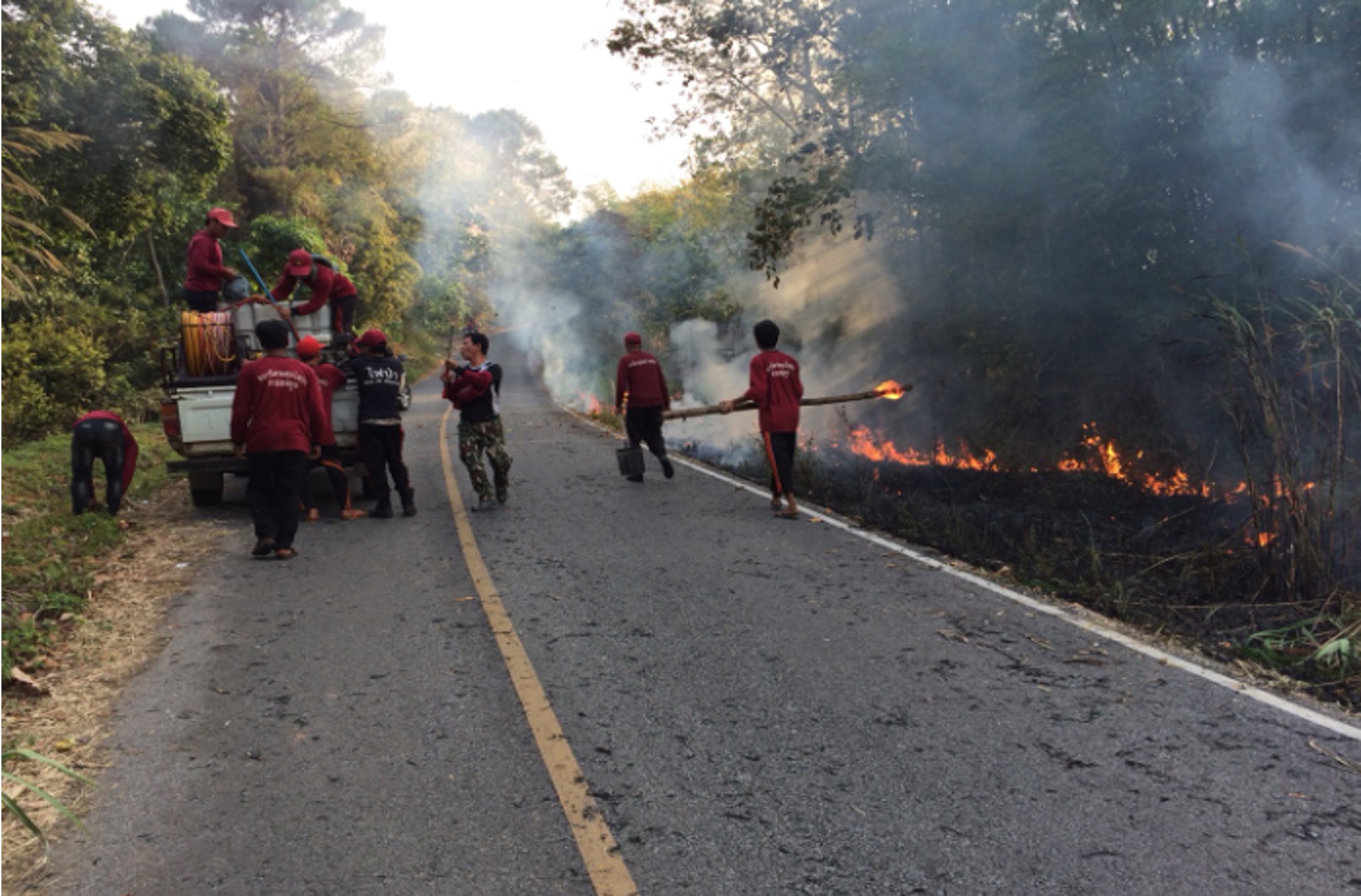
“[During fire season] we get about five hotspot alerts a day,” Natthaphon Singtuan, head of the forest fire volunteer center at the foundation, tells Mongabay. “We work with forest firefighters from the Department of National Parks, Wildlife and Plant Conservation to put out one to two hotspots every day. One hotspot takes about half a day to complete, but a big one might take us a full day to put out.”
The app has revolutionized the foundation’s firefighting process. In the past, only the Thai government had access to hotspot data from satellites, which it would send to local officials through email, Singtuan says.
“Now with the app, everybody can monitor the fires in real time,” he adds. “You can see their distribution and draw up a big picture plan to control the fires. You can draw up a route using Google Maps to get there within an hour, before the fire is out of control. And when you reach, you find some officials and local people will have already been there, because they have the app too … so we join forces. And the more people there are, the safer it is.”
Because the app allows local communities to monitor the fire situation alongside authorities, it has also fostered a sense of empathy and shared responsibility, Sirimongkonlertkul says.
“Before the app, we didn’t know how many hotspots there were. We only complained to the government, why don’t you stop the fires? But now … we can all see there are a lot of hotspots in our province, and it’s impossible for the government to solve this problem alone,” she says.
Now, Sirimongkonlertkul and her colleagues are working on adding features to an updated version of the original app. Named Smoke Watch, the new version uses more detailed hotspot data from the VIIRS satellite-based sensor, processed by SERVIR-Mekong, a project of USAID, NASA and countries in the Lower Mekong region that uses geospatial technologies to manage climate risks.
Smoke Watch, developed in collaboration with the Thai National Innovation Agency and local NGOs Asian Disaster Preparedness Center and Fulfill Social Enterprises, will incorporate statistics like wind speed and direction, and PM2.5 levels.
“It has only been tested with firefighters in Chiang Rai province this past fire season. The downloads are in the thousands,” Sirimongkonlertkul says. “In future, we are going to make sure the app is used more widely, covering the whole of Thailand and other countries in the Greater Mekong subregion.”
The upgrade is timely, Singtuan says, because the upcoming fire season is likely to see hotspots of greater magnitude and intensity. Villagers who lost their jobs to the COVID-19 pandemic have gone back to farming, and in Chiang Mai province, communities have been burning land for agriculture since mid-January, abetted by “perfect” weather conditions. “Humidity is low and there is a lot of dry fuel, so people can do the burning easily.”
Aekkapol Aekakkararungroj, a geospatial data scientist at SERVIR-Mekong, says the organization also has plans to expand Sirimongkonlertkul’s solution to nearby Laos. “We want to engage air pollution authorities and decision-makers in using geospatial tools, data sets, and mobile apps in addressing air pollution and fire management,” he says.

Beyond showing existing fire hotspots, Smoke Watch collates data over time to highlight the top provinces, districts and subdistricts in northern Thailand with the most fire hotspots. This indirectly drives communities to compete among themselves to reduce their hotspots, Sirimongkonlertkul says.
“We expect Smoke Watch to be a magic eye that acts like a cop, patrolling, urging people to watch out for burning,” she adds. “The app will help [build this idea] that burning is an act of embarrassment. If there is burning, it will appear on the mobile phone and everyone will know immediately and [be able to trace to] the owner of the area.”
When the researchers first approached various local communities in Chiang Rai, they found them hesitant to adopt the new technology. Over the years, this reluctance evaporated and the villagers worked out their own systems for putting out fires, Sirimongkonlertkul says. Today, whenever a village head gets a notification about a new hotspot within their area, they call for a meeting of volunteers in the village, who rush to put out the fire together.
“They don’t wait for help from the authorities, they try to help themselves first. Because fires will affect the image of their community, they will not let them happen so easily,” Sirimongkonlertkul says.

In a province where farmers have long burned land for agriculture whenever and however they want to, social stigma against unregulated burning is new. But because the evidence against air pollution and resulting respiratory problems is so clear, Sirimongkonlertkul and her colleagues are building a second app that aims to get farmers to transition to more sustainable ways of fertilizing their land.
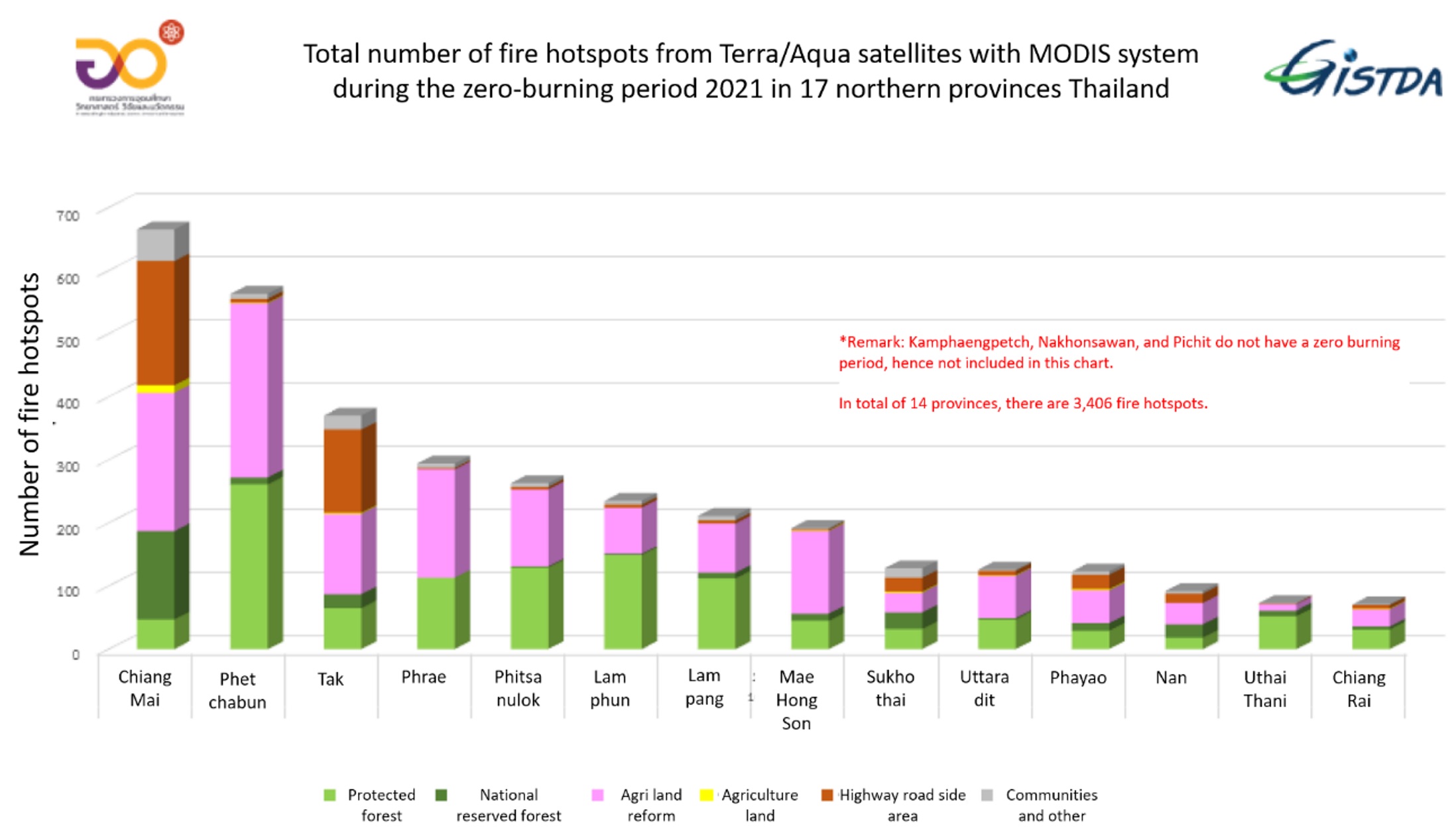
Called Burn Check, the app requires farmers to submit applications to the provincial authorities for approval before they can burn land for agriculture. A collaborative effort involving three local organizations — the Thai Pollution Control Department, the Geo-Informatics and Space Technology Development Agency and the Thai Health Promotion Foundation, Burn Check is currently being used by 17 provinces in northern Thailand.
At present, none of the requests submitted through Burn Check have been approved. They are collated and sent to the authorities, where they shed light on who wants to burn land, for what purposes. The goal is to make use of these farmers’ inputs in land-use planning and sustainable agricultural education, while reinforcing the idea that burning activities must be authorized instead of done arbitrarily, Sirimongkonlertkul says.
“The farmers, they are not happy to be honest,” she adds. “But because the pollution has a direct impact on their health, they want to find a way to have better air. They want alternative solutions instead of doing the same burning again and again.”
When Sirimongkonlertkul and her colleagues visit local communities, they often bring doctors and nurses with them. The health practitioners give the villagers a medical check, which typically surfaces symptoms of respiratory disease caused by PM2.5.
“We start by saying it’s the kids, the next generation, who will be impacted by air pollution. And we use scientific data and health data to give them very obvious evidence,” Sirimongkonlertkul says. “We do not say, you are to blame, or this village is to blame. We go with willingness, friendship and enthusiasm. It’s not about … using scientific data and the number of hotspots to put somebody on the spot. I want everybody to come together to solve this problem.”
Banner image of forest firefighters in Chiang Rai province, Thailand. Image courtesy of Nion Sirimongkonlertkul.
Editor’s note: This story was supported by XPRIZE Rainforest as part of their five-year competition to enhance understanding of the rainforest ecosystem. In respect to Mongabay’s policy on editorial independence, XPRIZE Rainforest does not have any right to assign, review, or edit any content published with their support.
FEEDBACK: Use this form to send a message to the author of this post. If you want to post a public comment, you can do that at the bottom of the page.


