- As of September 10, 2020 more than a thousand major blazes had occurred in the Amazon this year — making it one of the worst fire years ever.
- The COVID-19 pandemic means there are fewer observers, including media organizations, on the ground this year to report fires to the world, leaving the bulk of the job to satellite fire detection systems.
- This Mongabay exclusive story offers an overview of some of the top organizations doing satellite fire monitoring in Amazonia, as well as explaining the types of detection systems getting the job done — read on and you’ll learn the vital differences between “aerosol emissions” and “hot spot detection,” and much more.
- But no matter how good these observational systems become — even as they inform the world of what’s happening in the Amazon — monitoring won’t be fully useful until the Brazilian government takes effective action and uses revolutionary “near real time” fire data to protect the greatest extant rainforest on Earth.
This year’s Amazon fire season is one of the most serious ever, even though it’s not attracting near the media attention as last year. More than one thousand major fires have already been detected in the rainforest biome this year, with 82 major fires reported in protected areas and Indigenous territories, as of September 10, 2020.
Across the Brazilian Amazon, September has averaged 53 major fires per day (up from 18 in August) says the non-profit MAAP. But according to other sources, there are more than 6,000 hotspots flaring up in just a single day.
With statistics like these apparently diverging so widely among multiple sources, how do we know for sure what, and how much, rainforest is truly burning where? And how exactly are all these fires detected, and what do these numbers mean in reality?
To answer, we have to start in space.
Many satellites circle the Earth daily, some outfitted with tools tailored for fire monitoring. These devices record a variety of data that, when put together with other data sets, give us a multifaceted, well rounded, and increasingly accurate, view of the year’s fires.

These “near real time” fire detection systems fall into two major types: those sensing heat radiating from the Earth’s surface (“hotspots”) and those detecting aerosol emissions (particles released into the atmosphere from burning biomass). A fire’s presence can also be confirmed in some cases via high-resolution imagery, visual data also gathered by satellites.
An orbiting fire monitoring system basically works like this: a satellite instrument detects fires (either via hotspots or aerosol emissions). These fire alerts are relayed to individual organizations, including NASA or INPE, the Brazilian space agency, who process the incoming information to control for noise in the data (such as heat signals from an industrial blast furnace rather than an Amazon fire). The processed data is then sent to a visualization platform, bringing these satellite-based alerts to decisionmakers or the general public on the Internet. Several of these platforms now exist, including some that launched just this year. Each system analyzes the data somewhat differently — with each assessment valuable in its own way.
Some near real time Amazon fire monitoring platforms, by organization:
MAAP: The Amazon Real Time Fire Monitoring app uses aerosol detection data (ESA’s Sentinel-5P satellite TROPOMI data) verified with hotspot data and satellite imagery.
NASA: The U.S. space agency’s new Amazon Dashboard utilizes both hotspot and aerosol fire detection, combined with deforestation and land cover data to determine specifically what type of fires are burning.
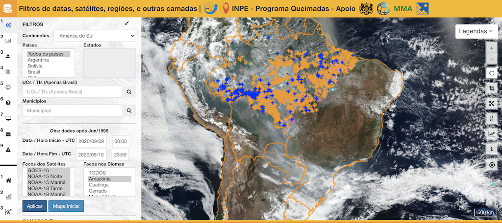
INPE: Brazil’s national space research institute (Programa Queimadas) uses hotspot data from many different satellites for its fire dashboard and fire monitoring program.
Global Forest Watch (GFW): Uses hotspot analysis (NASA’s Suomi NPP satellite VIIRS data), but primarily focuses on deforestation.
Infoamazonia: Fire Map uses hotspot data (VIIRS data)
Greenpeace: The NGO’s new Global Fire Dashboard uses hotspot data (NASA Aqua/Terra satellite MODIS data)
Hotspot data (sometimes called VIIRS or MODIS data) is widely reported in the media, but it can be misleading as a stand-alone metric for Amazon fires because hot spots aren’t well differentiated. Very small, localized events such as a farmer carrying out the yearly burn of corn stubble in a field can generate enough heat to send off an alert. The result is tens of thousands of undifferentiated hotspot alerts, when in reality, there may only be several hundred major deforestation-related fires or forest fires burning.
However, hotspot data is still useful for situational awareness and because it has been collected for decades, so is utilized for making quantitative and location comparisons over time. Also, because it is easily available and straightforward, hot spot data is used by several platforms including Global Forest Watch and Greenpeace’s new Global Fire Dashboard.
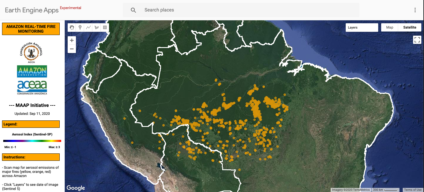
A closer look at MAAP Amazon fire detection
For Amazon fire reporting in 2020, Mongabay has relied heavily on the near-real time fire monitoring data provided by MAAP. MAAP’s novel Real-time Amazon Fire Monitoring app (launched in May 2020) uses a combination of aerosol emissions data, hot spot data, and verification from satellite imagery to report on what it calls “major fires.”
A “major fire” as defined by MAAP is one with an aerosol index of >1 (appearing cyan-green to red on the app). Once an alert is detected, MAAP uses hotspot data to pinpoint the source of aerosol emissions. Using the coordinates from this hotspot source, MAAP analyzes high-resolution satellite images from the Planet Explorer to confirm whether the fire is in a recently deforested area or in a standing forest, and measures the area burned.
Mongabay has also created its own fire dashboard based on MAAP data, which is regularly updated for use in stories.