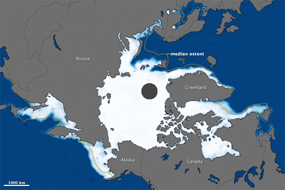
The map above was made from observations by the Special Sensor Microwave Imager/Sounder (SSMIS). Centered on the North Pole, the image shows sea ice concentration on March 18, with white indicating the greatest concentration and blue indicating open water. The median extent for maximum sea ice appears as a dull yellow line. The black circle is where the sensor recorded no data. Image courtesy of NASA.
Data released by the National Snow and Ice Data Center (NSIDC) shows that Arctic sea ice for the winter of 2011-2012 reached its maximum extent on March 18 at 15.24 million square kilometers (5.88 million square miles). The mark is well below the 1979–2000 average, but was above the record low of the 2010–2011 winter.
“The nine lowest maximum extents have occurred in the last nine years,” said Walt Meier of NSIDC.
Research shows the maximum sea ice extend is shifting later in the season. The cause for the change is unknown, although sea ice is also declining in the summer, when it typically reaches its minimum extent.
Sea ice hits its nadir in September before rebounding during the long Arctic winter. The loss of sea ice in the Arctic, which imperils a number of species, has been widely linked to climate change resulting global greenhouse gas emissions.
“Over the last decade, Arctic sea ice extents in September have set record lows three times, and the 2011 minimum nearly tied the 2007 record low,” said NASA in a statement.
Predictions range widely, but many experts expect the Arctic to be free of summer sea ice entirely within a few decades. By almost all standards, sea ice is disappearing faster than expected, partly a consequence of a positive feedback loop triggered by retreating ice. Sea ice typically helps cool the Arctic by reflecting sunlight back into space. But when sea ice melts, the dark areas of open water absorb the sun’s radiation, warming the region and worsening melting.
Related articles


