New Brazilian government data shows an area of Amazon rainforest 10 times the size of Manhattan was cleared in the past 2 months.

New data from the Brazilian government seems to confirm environmentalists’ fears that farmers and ranchers are clearing rainforest in anticipation of a weakening of the country’s rules governing forest protection.
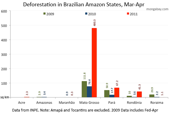
Wednesday, Brazil’s National Space Research Agency (INPE) announced a sharp rise in deforestation in March and April relative to the same period last year. INPE’s rapid deforestation detection system (DETER) recorded 593 square kilometers of forest clearing during the past two months, an area of rainforest 10 times the size of Manhattan and a 473 percent increase over the 103.5 sq km chopped down from March-April 2010.

|
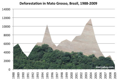
81 percent of the recent clearing occurred in Mato Grosso, the southernmost state in the Brazilian Amazon that has accounted for more than 35 percent of the region’s deforestation since 1988.
“The recent deforestation in Amazonia detected by INPE has been concentrated in the agricultural areas of the Mato Grosso state,” Gilberto Camara, Director of INPE, told mongabay.com. “Deforestation in these areas was high in the 1990s and early 2000s. From 2005 to 2010, due to increased law enforcement and private arrangements such as the Soy Moratorium, these areas had a substantial reduction on forest clearings.”
INPE’s announcement comes a day after Imazon, a research institute that also tracks deforestation, reported a big percent increase in clear-cutting. Imazon also found a surge in forest degradation, the logging, burning, and thinning of forest that often precedes deforestation.
The short-term deforestation tracking systems used by INPE and Imazon are used primarily for law enforcement. Both rely on relatively coarse satellite resolution, making them faster but less accurate than the systems used to determine annual deforestation, which is estimated every August. Month-to-month deforestation can be highly variable in Brazil, by clearing usually peaks in the dry season between July and October. High rates of clearing in April is unusual.

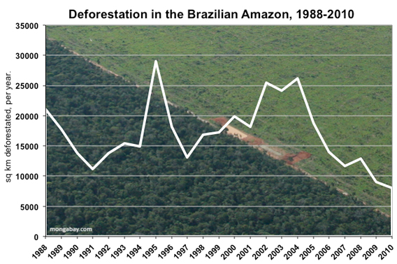
Until last month, the trend in the Brazilian Amazon had been very positive, with annual deforestation falling nearly 80 percent since 2004.
The increase in deforestation in April is thought to be linked to the current debate over Brazil’s forest code, which requires land owners to maintain 80 percent of their holdings as forest in the Amazon region. Anticipating a weakening in the code that would grant amnesty for deforestation, farmers and ranchers have been clearing swathes of forest. Dry conditions, lingering from last year’s worst-ever drought, have exacerbated the situation.
INPE’s Camara told mongabay.com that IBAMA, Brazil’s environment agency, just sent agents into the region to curb illegal clearing and report on what is causing the increase in deforestation.
Deforestation in the Brazilian Amazon is typically driven by industrial agriculture and land speculation. More than 70 percent of deforested land ends up as cattle pasture. High commodity prices typically create incentives for deforestation.
While only about 20 percent of the Brazilian Amazon has been lost to date, environmentalists fear that rising demand for food and fuel, combined with planned infrastructure projects and the effects of climate change, could doom much of the Amazon.
Related articles
Under pressure from rising deforestation, Brazil’s IBAMA establishes ‘Zero Deforestation Policy’ in the Amazon
(05/17/2011) IBAMA, Brazil’s equivalent of the EPA, is suspending 1,300 planned operations for 2011 in order to concentrate on curbing a spike in regional deforestation through a two-pronged strategy of greater institutional presence and reciprocal agreements with local municipal governments. Following a series of meetings in the Amazonian states of Pará, Mato Grosso, and Amazonas between IBAMA and political leaders, landowners, ranchers, and environmentalists, IBAMA announced a “Zero Deforestation Pact” last Wednesday in cooperation with the Federal Public Ministry (Ministério Público Federal). The increased emphasis on Amazonian forest protection follows the release of an IBAMA document obtained by Folha revealing a jump in Amazonian deforestation that the government believes is related to proposed changes to relax the Forest Code, a debate which has given confidence to those deforesting.
Huge surge in Amazon deforestation
(05/17/2011) Analysis by Imazon, a research institute, has confirmed a huge surge in deforestation in a critical part of the Brazilian Amazon.
Information leak: Amazon deforestation increases sharply while forest code debated
(05/16/2011) Deforestation has increased sharply in Mato Grosso over the past nine months according to information leaked to Folha.com.
Monitoring deforestation: an interview with Gilberto Camara, head of Brazil’s space agency INPE

(02/08/2011) Perhaps unsurprisingly, the world’s best deforestation tracking system is found in the country with the most rainforest: Brazil. Following international outcry over immense forest loss in the 1980s, Brazil in the 1990s set in motion a plan to develop a satellite-based system for tracking changes in forest cover. In 2003 Brazil made the system available to the world via its web site, providing transparency on an issue that was until then seen as a badge of shame by some. Since then Brazil has become recognized as the standard-bearer for deforestation tracking and reporting—no other country offers the kind of data Brazil provides. Space engineer Gilberto Camara has overseen much of INPE’s earth sensing work and during his watch, INPE has released several new exciting capabilities.
How satellites are used in conservation

(04/13/2009) In October 2008 scientists with the Royal Botanical Garden at Kew discovered a host of previously unknown species in a remote highland forest in Mozambique. The find was no accident: three years earlier, conservationist Julian Bayliss identified the site—Mount Mabu—using Google Earth, a tool that’s rapidly becoming a critical part of conservation efforts around the world. As the discovery in Mozambique suggests, remote sensing is being used for a bewildering array of applications, from monitoring sea ice to detecting deforestation to tracking wildlife. The number of uses grows as the technology matures and becomes more widely available. Google Earth may represent a critical point, bringing the power of remote sensing to the masses and allowing anyone with an Internet connection to attach data to a geographic representation of Earth.
How to save the Amazon rainforest
(01/04/2009) Environmentalists have long voiced concern over the vanishing Amazon rainforest, but they haven’t been particularly effective at slowing forest loss. In fact, despite the hundreds of millions of dollars in donor funds that have flowed into the region since 2000 and the establishment of more than 100 million hectares of protected areas since 2002, average annual deforestation rates have increased since the 1990s, peaking at 73,785 square kilometers (28,488 square miles) of forest loss between 2002 and 2004. With land prices fast appreciating, cattle ranching and industrial soy farms expanding, and billions of dollars’ worth of new infrastructure projects in the works, development pressure on the Amazon is expected to accelerate. Given these trends, it is apparent that conservation efforts alone will not determine the fate of the Amazon or other rainforests. Some argue that market measures, which value forests for the ecosystem services they provide as well as reward developers for environmental performance, will be the key to saving the Amazon from large-scale destruction. In the end it may be the very markets currently driving deforestation that save forests.
Future threats to the Amazon rainforest
(07/31/2008) Between June 2000 and June 2008, more than 150,000 square kilometers of rainforest were cleared in the Brazilian Amazon. While deforestation rates have slowed since 2004, forest loss is expected to continue for the foreseeable future. This is a look at past, current and potential future drivers of deforestation in the Brazilian Amazon.


