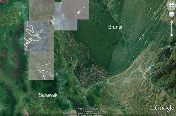
Logging roads and damaged forest in Sarawak compared with the healthy forest of Brunei. Photo courtesy of Google Earth.
Images from Google Earth show a sharp contract between forest cover in Sarawak, a state in Malaysian Borneo, and the neighboring countries of Brunei and Indonesia at a time when Sarawak’s Chief Minister Pehin Sri Abdul Taib Mahmud is claiming that 70 percent of Sarawak’s forest cover is intact.
Google Earth images from GeoEye, TerraMetrics, Tele Atlas, Europa Technologies, and other providers show logging roads snaking across Sarawak’s forest areas. Forests across international borders are substantially less impacted, as viewed on Google Earth.
The images seem to lend support to claims from environmentalists that Sarawak’s forests have been heavily logged. Some groups estimate that Sarawak has lost 90 percent of its primary forest cover. Most of what remains is forest that has been selectively — but heavily — logged two or three times in the past 30 years. Some forest areas have been converted for timber, wood-pulp, and timber plantations.
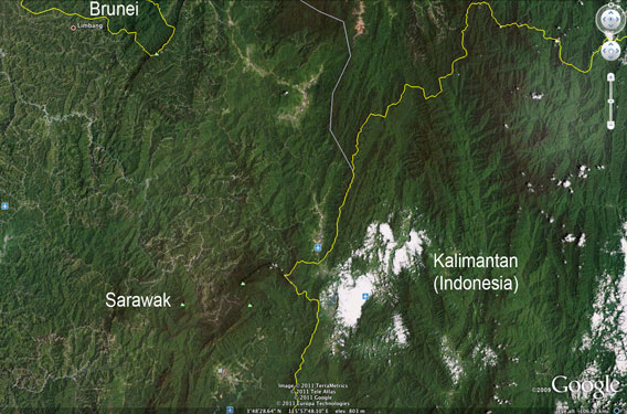
Logging roads and damaged forest in Sarawak compared with healthier forest in Kalimantan (Indonesian Borneo). Photo courtesy of Google Earth.
Last week Chief Minister Taib said that 70 percent of Sarawak’s rainforest is intact, while 14 percent of its “secondary forests” has been replanted or is in the process of being converted to plantations. Taib invited independent observers to assess Sarawak’s forest cover.
“People can make many claims, but my government has been very deeply committed to sustainable management of our forest,” he said in an interview with Sarawak Reports, a web site created earlier this month by the Chief Minister’s supporters. “These are the simple facts and if people want to verify, they are welcome to Sarawak. I’ll be open for… independent inspection and I have nothing to hide.”
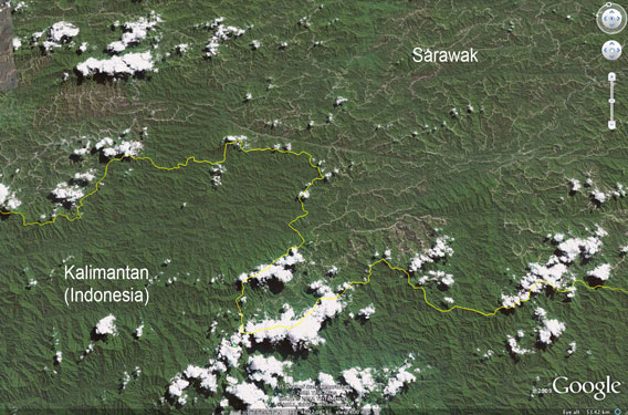
Logging roads and damaged forest in Sarawak compared with healthy forest in Kalimantan (Indonesian Borneo). Photo courtesy of Google Earth.
Taib has come under pressure in recent months from campaigners who have linked him and his family to hundreds of millions of dollars’ worth of overseas properties. The holdings, which are uncleared and would seem to be illegally acquired, are believed to be tied to Taib’s interests in the forestry sector.
The campaign against Taib has been led by the Clare Rewcastle Brown, the sister-in-law of British former Prime Minister Gordon Brown, who helps run the Sarawak Report and Radio Free Sarawak. Both outlets have come under heavy pressure from the government of Sarawak, which, together with logging companies which own publications like the Borneo Post, control much of the state’s print media. Accordingly, Sarawak media has lately become very critical of the former British Prime Minister, who recently described the deforestation of Sarawak as “probably the biggest environmental crime of our times”.
Lukas Straumann of the Bruno Manser Fund, a group that has long advocated on behalf of Sarawak’s forest people, expressed doubt that Taib would follow through on his pledge to allow independent examination of Sarawak’s forests.
“Taib has never allowed any foreign inspection of Sarawak’s forests since the 1991 ITTO mission which had not turned out the way he had hoped. In particular, he has consistently refused ITTO to conduct a follow-up mission,” he told mongabay.com.
“We know from satellite imagery that less than 10% (possibly less than 5%) of Sarawak’s forests are still intact. Taib himself stated in 2001 that 90% of loggable trees had been cut so that the forestry industry needed to start looking out for new sources of timber.”
According to state data, Sarawak’s timber production peaked in the 1990s.
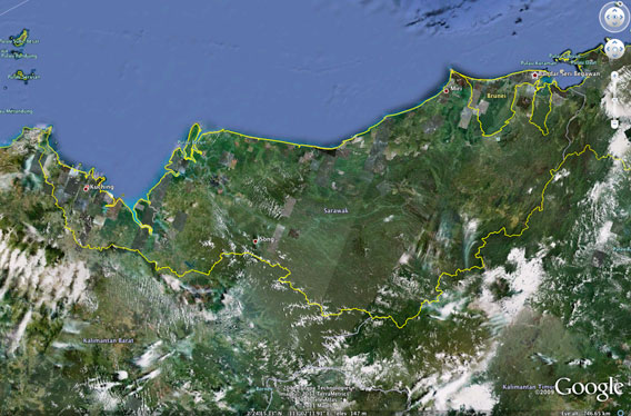
Sarawak and neighboring areas. Photo courtesy of Google Earth.
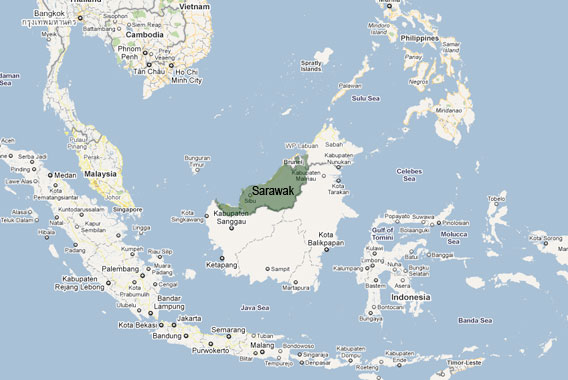
Sarawak and neighboring areas. Map courtesy of Google Maps.
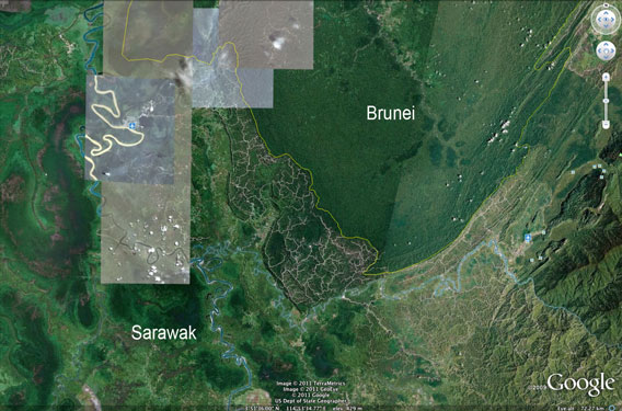
Logging roads and damaged forest in Sarawak compared with healthy forest in Brunei. Photo courtesy of Google Earth.
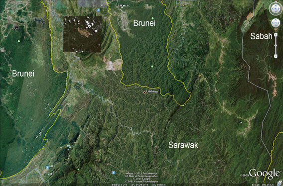
Logging roads and damaged forest in Sarawak compared with healthy forest in Brunei. Photo courtesy of Google Earth.
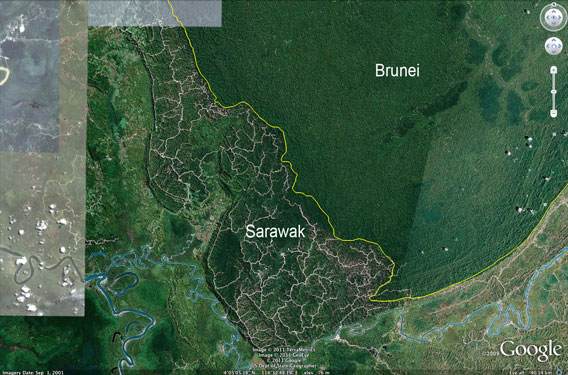
Logging roads and damaged forest in Sarawak compared with healthy forest in Brunei. Photo courtesy of Google Earth.
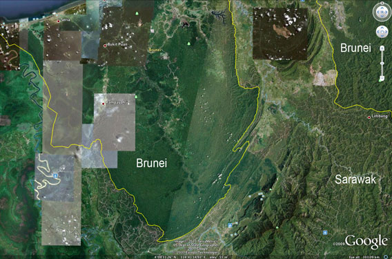
Logging roads and damaged forest in Sarawak compared with healthy forest in Brunei. Photo courtesy of Google Earth.
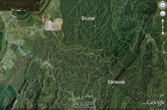
Logging roads and damaged forest in Sarawak compared with healthy forest in Brunei. Photo courtesy of Google Earth.
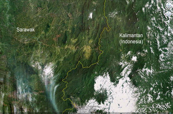
Logging roads and damaged forest in Sarawak compared with healthier forest in East Kalimantan (Indonesian Borneo). Photo courtesy of Google Earth.

Logging roads and damaged forest in Sarawak compared with rainforest in Kalimantan (Indonesian Borneo). Photo courtesy of Google Earth.
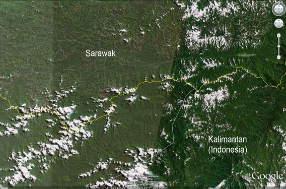
Logging roads and damaged forest in Sarawak compared with the healthy forest of Kalimantan (Indonesian Borneo). Photo courtesy of Google Earth.
Related articles
Report: corruption in Sarawak led to widespread deforestation, violations of indigenous rights
(03/10/2011) At the end of this month it will be 30 years since Abdul Taib Mahmud came to power in the Malaysian state of Sarawak. Environmentalists are using the occasion, along with new revelations, to highlight corruption and nepotism they say have characterized his regime. Chief Minister Taib and his decades-long administration are no strangers to such allegations, but a new report from the indigenous-rights group Bruno Manser Fund (BMF)—amid criticism from independent media sources, such as Sarawak Report and Radio Free Sarawak—are adding fuel to the fire. Most recently, the report describes in great detail how the tropical timber trade in Sarawak has undercut indigenous groups while toppling some of the world’s greatest rainforests, all at the expense of the Sarawak people.
Sarawak’s last nomad: indigenous leader and activist, Along Sega, dies

(02/03/2011) Along Sega never knew exactly how old he was, but when he passed away yesterday in a hospital far from the forest where he born, he was likely in his 70s. Leader among the once-nomadic hunter and gatherer Penan people of Borneo and mentor to Swiss activist, Bruno Manser, Along Sega will be remembered for his work to save the Penan’s forest—and their lifestyle and culture—from logging companies, supported by the Sarawak government and provided muscle by the state police.
Malaysian palm oil producers destroying Borneo peat forests faster than ever before
(02/01/2011) Peatlands and rainforests in Malaysia’s Sarawak state on the island of Borneo are being rapidly destroyed for oil palm plantations, according to new studies by environmental group Wetlands International and remote sensing institute Sarvision. The analysis shows that more than one third (353,000 hectares or 872,000 acres) of Sarawak’s peatswamp forests and ten percent of the state’s rainforests were cleared between 2005 and 2010. About 65 percent of the area was converted for oil palm, which is replacing logging as timber stocks have been exhausted by unsustainable harvesting practices.
Sarawak to double oil palm plantations by focusing on native customary forest
(11/30/2010) Sarawak plans to double its oil palm estate by 2020, reports The Star.
Misleading claims from a palm oil lobbyist
(10/23/2010) In an editorial published October 9th in the New Straits Times (“Why does World Bank hate palm oil?”), Alan Oxley, a former Australian diplomat who now serves as a lobbyist for logging and plantation companies, makes erroneous claims in his case against the World Bank and the International Finance Corp (IFC) for establishing stronger social and environmental criteria for lending to palm oil companies. It is important to put Mr. Oxley’s editorial in the context of his broader efforts to reduce protections for rural communities and the environment.
Photos: Massive logjam in Borneo blocks Malaysia’s longest river
(10/10/2010) A massive 50-km-long (30-mi) logjam has blocked the Rajang river in Sarawak, Malaysian Borneo, bringing river traffic to a standstill and posing a threat to riverbank communities, reports Malaysian state media, Bernama. The Rajang, Malaysia’s longest river, is presently unnavigable, according to Bernama. The source of the logs and debris is believed to be the Baleh River and upper tributaries of the Rajang. Heavy rain reportedly triggered a landslide or landslides at log ponds at a major timber camp.


