Mongabay founder Rhett A. Butler writes about his visit to Indonesian Borneo last month.
The goal of the Kalimantan trip was to ground-truth some GPS points that satellite data via Global Forest Watch suggested could be areas of recent deforestation.
This post is insider content, which is available to paying subscribers.
Borneo has been special to me since my earliest years. As a kid, I would voraciously read books about the wilds of Borneo, with its dense rainforests inhabited by traditional indigenous peoples and wondrous animals like orangutans, clouded leopards, and pygmy elephants. As I grew older, I became aware of the environmental devastation in Borneo. Back then, in the 1980s, the story was mostly about logging. Palm oil was still a relatively nascent industry in Borneo.
When I was in high school, I had the amazing opportunity to visit Borneo in person thanks to my mother, a travel agent who specialized in international destinations. We visited forests in the state-operated Yayasan Sabah concession, in Malaysian Borneo. Some of my fondest memories are from visiting that forest: hiking under the tall trees, swimming in the crystal-clear creeks, and seeing incredible frogs, lizards, and insects. The most special moment, though, came as I sat on a log next to a creek picking leeches off my pant legs and socks. I heard some rustling and looked up to see a wild male orangutan in the trees above me. He was huge, with the fully developed face plates characteristic of adult males. He didn’t linger long, but I’ll always treasure that memory.
A few days after that experience, I returned home to California. But I kept in correspondence with Clive Marsh, the conservation biologist I met on that trip. A few months later he wrote to give me the heart-breaking news that the forest I so enjoyed had been logged for a pulp and paper scheme. That moment was an inflection point for me: born out of that sad news was a person impassioned to make a difference. Within days of getting that letter I began writing a book about tropical rainforests that would lay the groundwork for Mongabay.
Old-growth rainforest along the Utik river in Sungai Utik customary forest in Kapuas Hulu Regency, West Kalimantan, Indonesia. Photo by Rhett A. Butler
Earlier this month I had the opportunity return to Borneo, as I’ve done many times since that first fateful trip. This time I would be spending a few days in West Kalimantan in Indonesian Borneo, following a conference and series of meetings in Singapore. The goal of the Kalimantan trip was to ground-truth some GPS points that satellite data via Global Forest Watch suggested could be areas of recent deforestation, and to visit the Iban community of Sungai Utik, which recently won the United Nations Development Programme’s Equator Prize for its efforts to conserve and sustainably manage its traditional forest.
The Indonesian portion of the trip got off to an inauspicious start, with my flight from Singapore to Jakarta getting canceled at the last minute. With a tight connection in Jakarta, the likelihood of me making it to Pontianak, the capital of West Kalimantan, that day looked slim, but after doing a number of flight searches and running between terminals in Singapore, I successfully stood by on a flight that got me to Jakarta about an hour before my plane to Pontianak. Miraculously, and with a lot of breathless running around the airport in Jakarta, I was able to clear immigration and transfer terminals in time to make my connection.
Once I reached Pontianak, I met up with Sapariah “Arie” Saturi, Mongabay Indonesia’s senior staff writer, and our local correspondent Aseanty “Levy” Pahlevi, who would be helping with logistics and translation the next few days. The plan was to leave the hotel in Pontianak at 6 a.m. the next morning to visit several GPS points where Global Forest Watch’s GLAD alert system indicated a recent change in forest cover. I had a brought a drone and camera to help with documentation, while Levy and Arie would handle the on-the-ground investigative work to support any of the reporting that might result from the trip.
But there was a complication. Ramadan had just ended so it was Eid al-Fitr, a religious holiday where many Indonesians return to their hometowns to celebrate with their families. Accordingly, there was a severe shortage of rental vehicles, and when the car we reserved was not returned on time, we had to scramble to find transportation to get us to the GPS points scattered around Pontianak.
Burned peat forest in West Kalimantan, Indonesia. Photo by Rhett A. Butler
Day One: Car trouble, suburban sites, and MSL
Six a.m. came and went. 7 a.m. 8 a.m. 9 a.m. 10 a.m. The hours ticked by. Finally, a bit past 11 a.m., we found a car and hit the road. The late start limited the number of GPS points we could visit the first day, so we started with two sites near the city.
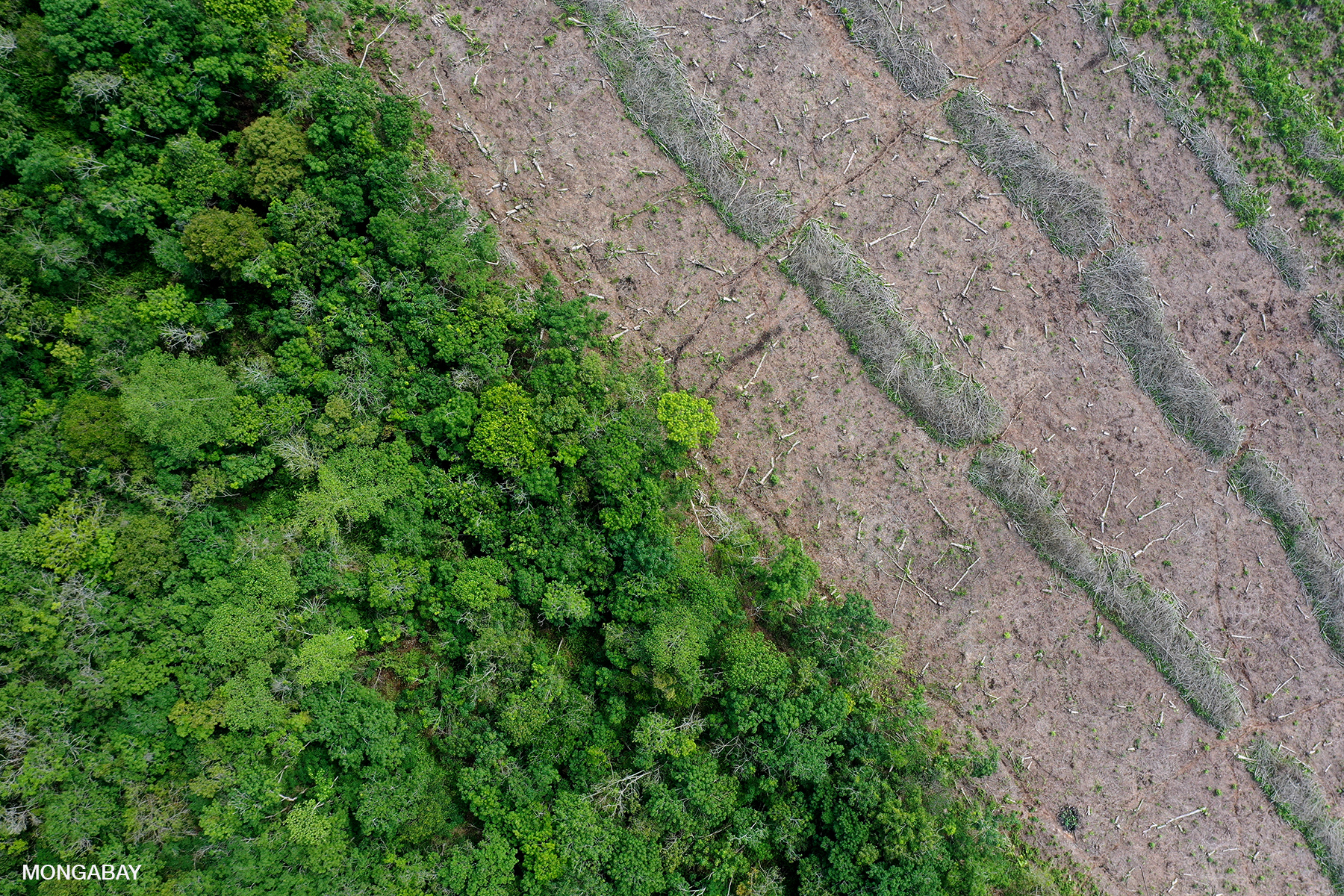
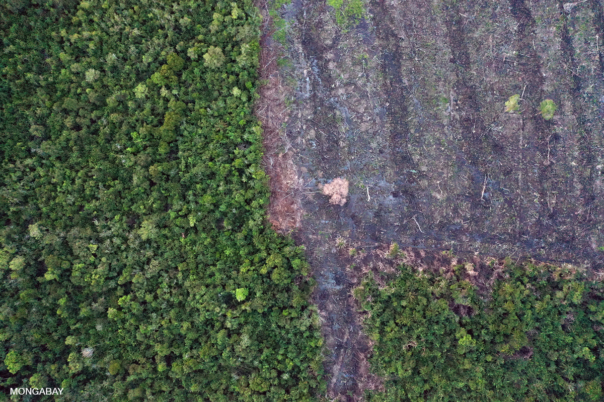
The first site was peat forest that was being cleared in patches. Locals told us they were cutting timber and “poles” from the forest, before converting these areas for rice and small-scale agriculture.
Canopy of a peat forest. Photo by Rhett A. ButlerRecently logged peatlands. Photo by Rhett A. Butler
As I flew the drone, a small crowd from the village gathered around to watch. The kids were especially fascinated to see the overhead view of the nearby forest and peatlands.
The second site was also in the suburbs of Pontianak. We turned off a paved road onto a dirt track and drove until we reached the point closest to the area of apparent deforestation based on imagery from Planet’s constellation of satellites and Global Forest Watch. Forest clearing here seemed to be for the extension of a real estate development and small plantations.
Forest clearing for urban expansion near Pontianak, Indonesia. Photo by Rhett A. Butler.Forest clearing near Pontianak, Indonesia. Photo by Rhett A. Butler.Forest clearing for urban expansion near Pontianak, Indonesia. Photo by Rhett A. Butler.Forest clearing for urban expansion near Pontianak, Indonesia. Photo by Rhett A. Butler.Forest clearing for urban expansion near Pontianak, Indonesia. Photo by Rhett A. Butler.
After visiting the suburban sites, we set off for a pulp and paper concession controlled by PT Muara Sungai Landak (MSL), a shadow supplier for Asia Pulp & Paper (APP) that has continued to clear forests and peatlands despite APP’s Forest Conservation Policy, which bars such activities. Investigative reporting in 2017 by the Associated Press and Mongabay revealed the links between APP and MSL.
The drive to MSL’s concession took longer than anticipated due to our car breaking down several times. But we eventually made it to the dirt road that took us toward the plantation.
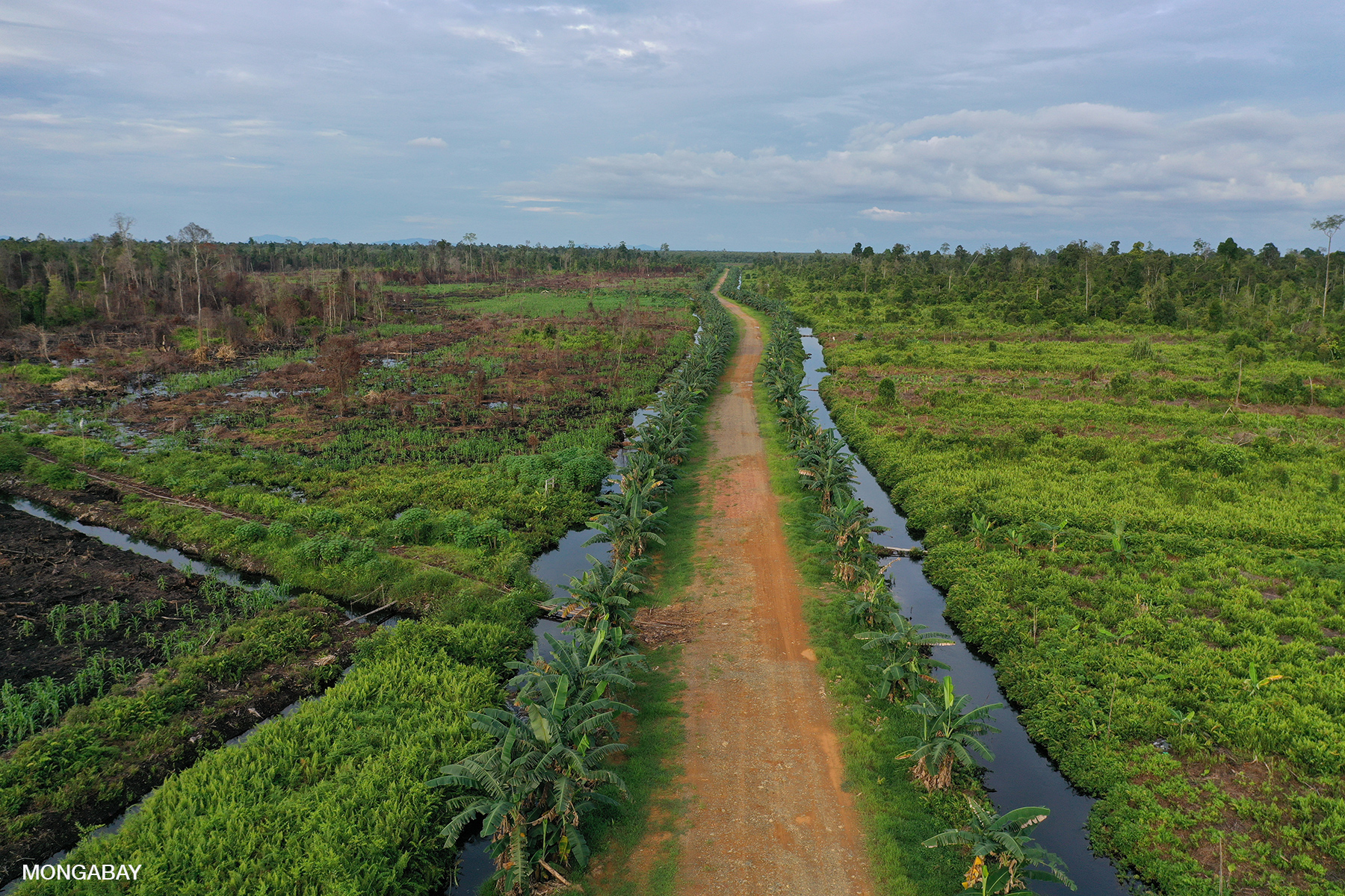
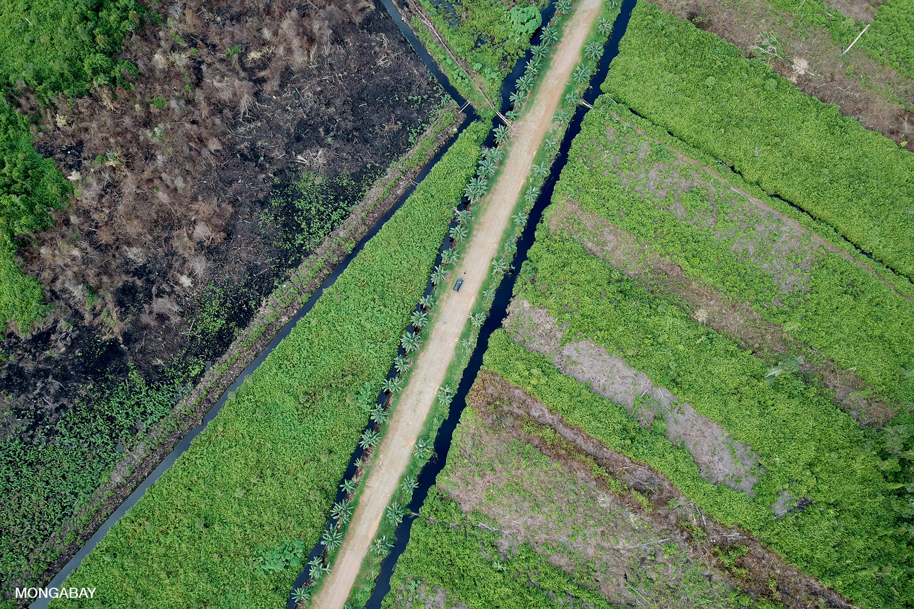
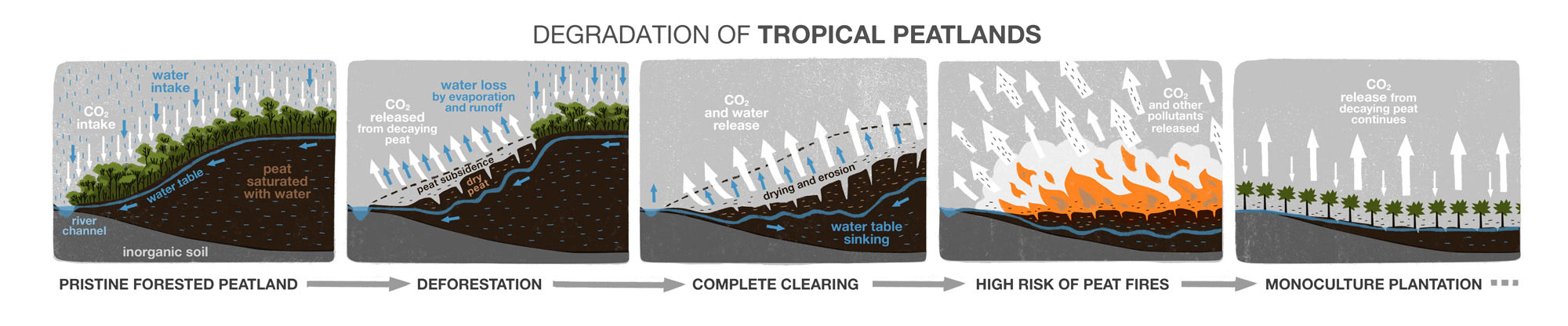
Running alongside the road to MSL’s concession were canals draining ink-black water from the surrounding peatlands. Plantation companies typically drain peatlands to make them suitable for oil palm or acacia cultivation. But lowering the water table in peatlands is problematic. Drained peatlands are highly flammable — the “haze” that blankets Indonesia, Malaysia, and Singapore every few years is driven primarily by peat fires. These fires release tens of millions of tons of carbon into the atmosphere. So while companies like APP tend to blame smallholders and villagers for setting fires that burn peatlands, these companies are in fact responsible for creating conditions that exacerbate peat fires and the recurrent haze crisis.
Road running through drained and burned peatlands. Photo by Rhett A. ButlerDrained, cleared, and burned peat forest in Indonesian Borneo. Photo by Rhett A. ButlerDrained, cleared, and burned peat forest in Indonesian Borneo. Photo by Rhett A. ButlerRoad running through drained and burned peatlands. Photo by Rhett A. ButlerDrained, cleared, and burned peat forest in Indonesian Borneo. Photo by Rhett A. ButlerDrained, cleared, and burned peat forest in Indonesian Borneo. Photo by Rhett A. Butler
Even without fire, drained peatlands are a major source of greenhouse gas emissions due to oxidation. And drainage also leads to subsidence, which heightens the risk of catastrophic flooding during heavy rains.
Art by Prabha Mallya
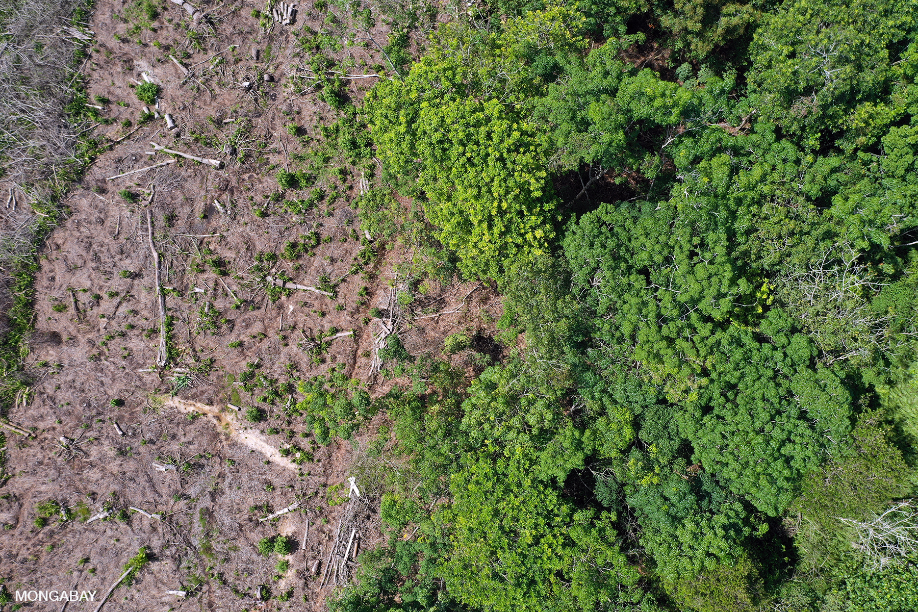
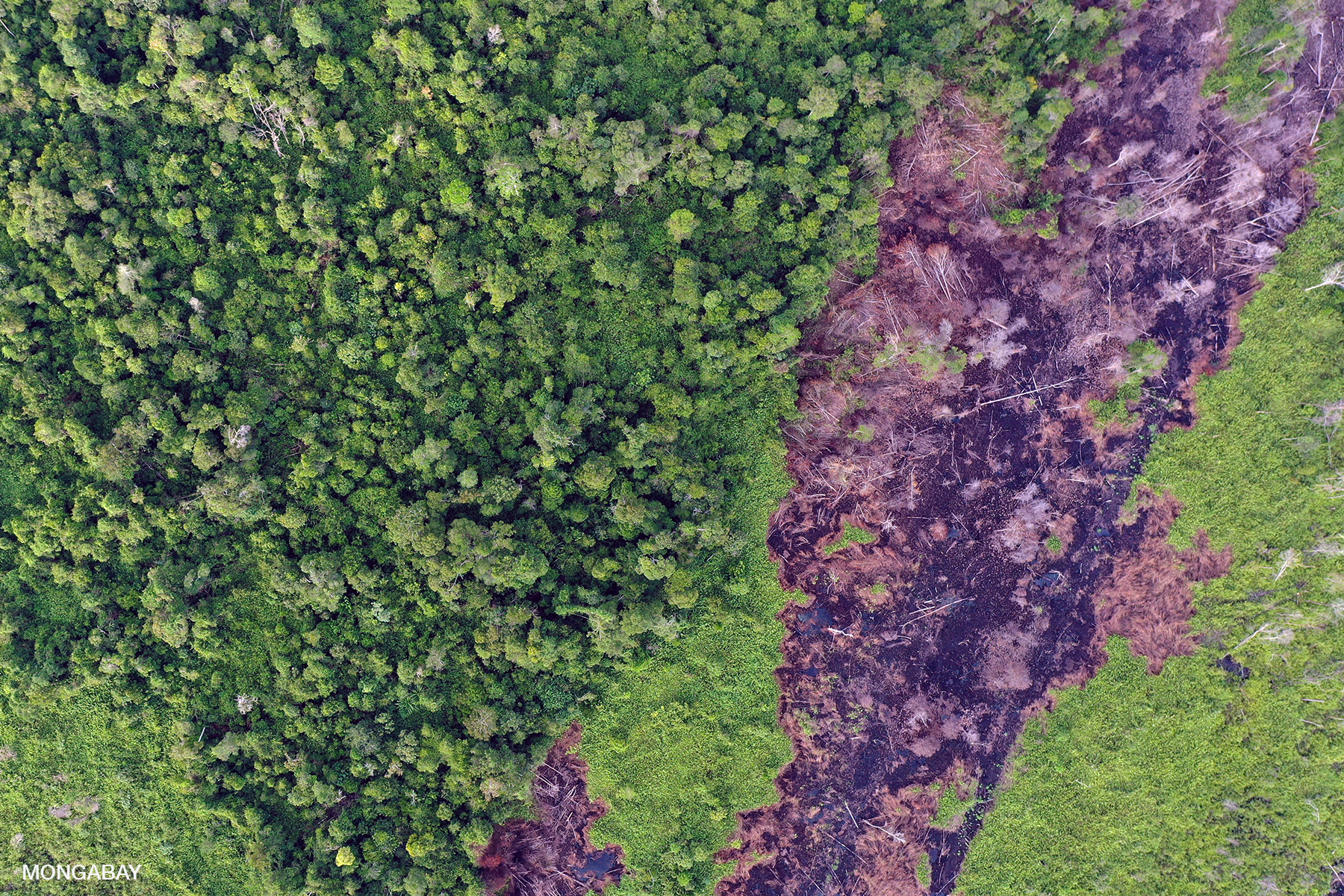
Indeed, our visit to GPS points identified via Global Forest Watch revealed recent fire damage, including blackened trees, charred ground vegetation, and ferns that sprout in the aftermath of fire. An overflight with the drone confirmed the damage, showing substantial forest clearing and degradation, as well as a network of drainage canals.
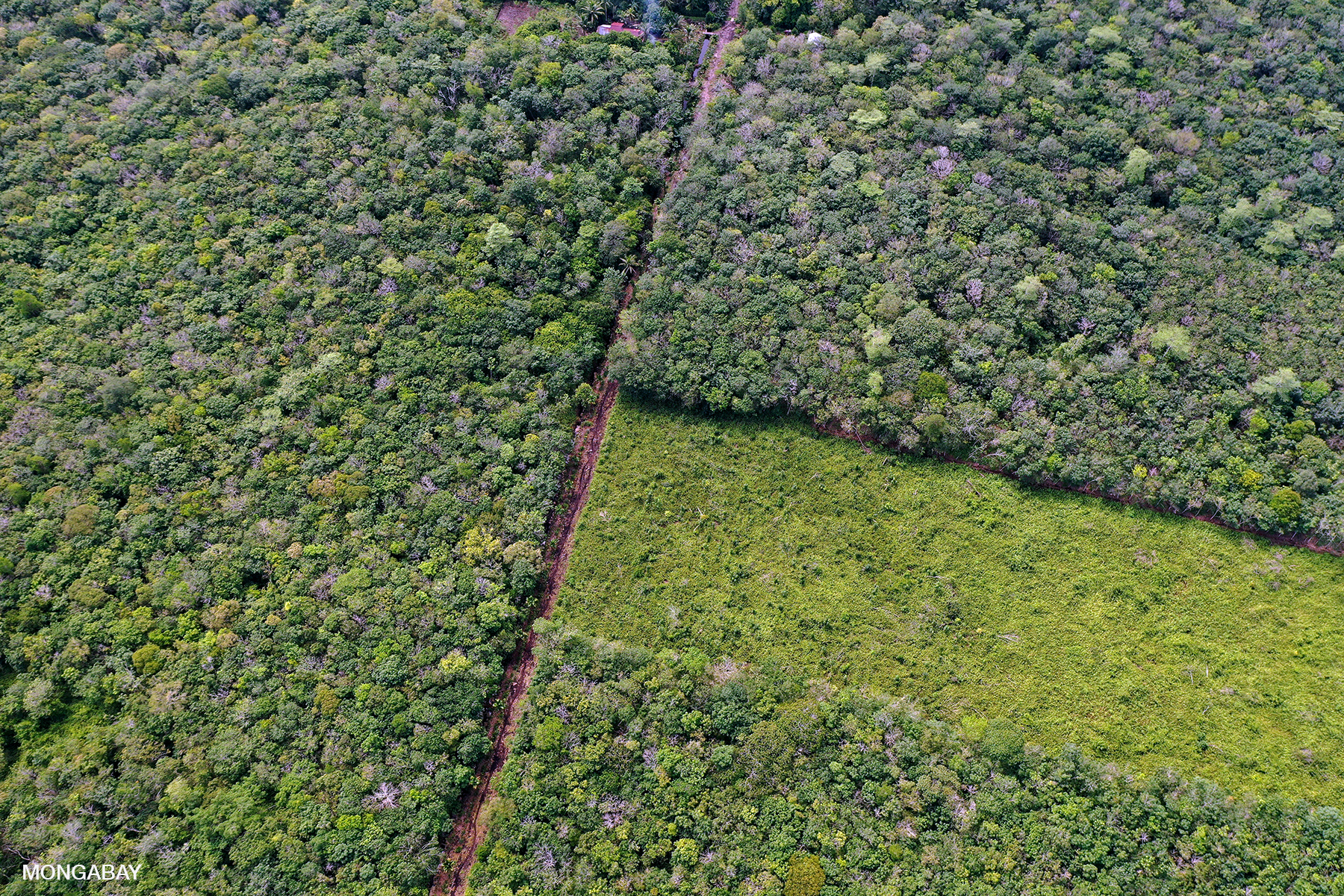
I flew the drone over a large block of community forest that still had tall trees, but was nonetheless being drained and looked to be degraded. We also saw MSL’s massive acacia plantation.
We eventually made our way back to the coast, visiting a few more GPS points on the way. We again had a couple of breakdowns that delayed us a few more hours, making for a very late night. We hoped that our original car would be available for the second day of field work around Pontianak.
Gold mining near Mandor in West Kalimantan, Indonesia. Photo by Rhett A. Butler
Day Two: Gold mining and oil palm
Day two started much like day one, with uncertainty about the car. Levy spent much of the night and morning trying to locate another car, but in the end, we were stuck with the vehicle from day one. Instead of a 6 a.m. departure, we left at 10 a.m. and immediately had car problems, which led us to being stranded a few times on the side of the road as the driver sought help from village mechanics.
Eventually the car problems were sorted out and we headed to Mandor, a town in Landak district, that’s most obvious in satellite imagery for the adjacent mining, which on Google Earth resembles a white moonscape pockmarked by black ponds. Both gold mining and sand mining still occurs here.
Beyond the mining, Mandor is known for its memorial marking atrocities during the Japanese occupation of World War II. In the early afternoon heat, the memorial was completely deserted. We set up operations several hundred meters (yards) south from the memorial and launched the drone.
Gold and sand mining near Mandor, West Kalimantan, Indonesian Borneo. Photo by Rhett A. Butler.Gold and sand mining near Mandor, West Kalimantan, Indonesian Borneo. Photo by Rhett A. Butler.Gold and sand mining near Mandor, West Kalimantan, Indonesian Borneo. Photo by Rhett A. Butler.
The drone revealed a stark contrast between the rainforest and the blinding white sand of the deforested areas and former riverbed. Because of the holiday, there wasn’t much active mining. The drone flew over empty mining compounds and campsites.
The block of forest that makes up the Mandor wildlife sanctuary is contiguous with the area of forest I flew over the day before near the MSL concession. I could see that there was indeed quite a large extent of good wildlife habitat here.
After Mandor, we visited some oil palm plantations beyond Mandor and then along the road back to the coast. Due to the car problems, we didn’t have time to fly all the sites I had mapped out, but we nonetheless were able to check out some GPS points where GLAD alerts indicated recent deforestation.
We concluded the day with a visit to an area of recent clearing on the edge of the city of Mempawah just after sunset. Low visibility made for a short flight.
Deforestation near Mempawah. Photo by Rhett A. Butler.
The next day we were headed to Kapuas Hulu to visit the Iban community at Sungai Utik. We expected this portion of the trip to be a lot different from the past two days: we’d be visiting some old-growth rainforest that has been preserved thanks to the people of Sungai Utik.