This article is the first in a two-part series that examines deforestation trends and drivers in Assam, India. Read the second part here.
Northeastern India is a distinct entity in many ways. The region is connected to the rest of the country by a narrow strip of Indian land, with a width of just 21 to 40 kilometers (13 to 25 miles). The region has more than 250 indigenous groups that speak a variety of languages. The area is also part of the Eastern Himalaya biodiversity hotspot, one of the megadiverse areas of the world; a meeting ground of temperate east Himalayan flora, the paleo-arctic flora of the Tibetan highlands and wet evergreen flora of Southeast Asia.
The region boasts more than 60 percent forest cover, compared to the 15 percent for India as a whole. However, not all is pristine when one visits areas designated as forest on the map.
“It’s hard to say when you’ve entered a forest in Assam’s Sonitpur district. The green marking on official maps is not what you see on the ground,” writes Jay Mazoomdar, an investigative journalist based in Delhi. Most forests are “open forests,” which means their canopy densities are between 10 and 40 percent. “Dense forests” with canopy densities of 40 percent or higher are relatively rare in northeast India.

Assam is home to Indian rhinoceroses (Rhinoceros unicornis), among many other species. Photo by Lip Kee.
The practice of shifting cultivation, called “jhum,” is probably one of the reasons why much of the forest is “open.” The practice, common in northeastern India, involves cutting down and/or burning patches of forest to cultivate crops. After the last crops are harvested, the patch is abandoned, or left “fallow,” to allow the natural vegetation, mostly bamboo, to regrow and the soil to regenerate. Previously, the land was allowed to rest for 20 to 30 years; however, with increasing population the interval has been reduced to as little as two to three years.
Around 450,000 families in northeastern India annually cultivate 10,000 square kilometers (3,800 square miles), with the total area affected by “jhumming” amounting to approximately 44,000 square kilometers (15,400 square miles). Due to reduced fallow periods, forest regeneration of young secondary forest is halted by crop planting, changing the landscape extensively. Degraded forests, bamboo thickets and weeds dominate these areas. Short jhum cycles also cause loss of soil nutrients through runoff and leaching, eventually making the land unsuitable for agriculture.
Community-owned forests
Unlike the rest of India, forests in northeastern India are predominantly owned by the local communities. In all, there are about 250 ethno-linguistic tribal communities in the region. State forest departments administer reserves and protected areas; however, formally designated protected areas cover less than 8 percent of the region’s forests—despite a rise in land designated as protected areas from 1 percent of the region 1989 to 5 percent in 2006. “Much of this territory remains ‘paper parks,’ in many cases with limited functioning management on the ground,” states a background paper prepared by Community Forest International.
Global Forest Watch (GFW) shows that India as a whole lost about 842,200 hectares of forest between 2001 and 2012. Of this, about 548,440 hectares was lost from northeast India alone. In other words, 65 percent of the country’s forest loss happened in a region that comprises just 7 percent of its land area.
The Kameng Protected Area Complex, including the Sonai Rupai Wildlife Sanctuary in Assam, the Eaglenest and Sessa Sanctuaries in Arunachal Pradesh, and their associated Reserve Forests, encompasses about 3,500 square kilometers, forming the largest contiguous forest tract in the Eastern Himalayas. However, Sonitpur and its surrounding areas have experienced significant deforestation in recent times, linked to the volatile socio-political situation of the region.

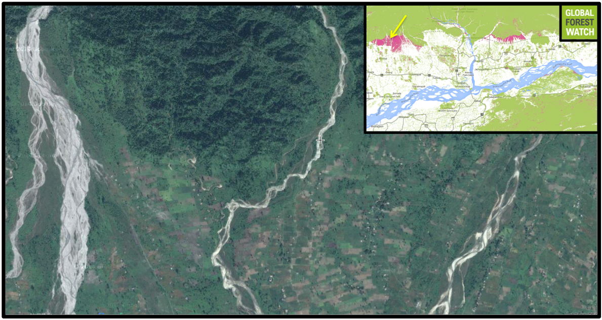
Sonitpur district in Assam and the surrounding region has experienced significant forest loss in some areas. Even protected areas such as Sonai Rupai Wildlife Sanctuary (yellow circle) are not immune. Map courtesy of Global Forest Watch. Click to enlarge.
Satellite imagery shows cleared tracts of land in Sonai Rupai Wildlife Sanctuary. Courtesy of Global Forest Watch. Click to enlarge.
The area encompassing Kameng and Sonitpur elephant reserves was once one of the greenest in Assam, with lowland deciduous forests called “dooars” that are prime habitat for elephants. However, in the 1990s, the Bodos— the largest of the tribes that occupy Assam’s plains—started agitating for a separate “Bodoland.” Since then, Bodos from all over Assam have moved to these areas to increase numbers and ensure a majority.
This has had consequences on the area’s forests, with large-scale encroachment systematically felling the dooars. The kind of animals found in the area consequently underwent a transformation. In the 1990s, Bengal tigers (Panthera tigris tigris)
were a common sight along roadsides in Sonitpur. This implied the forest was relatively undisturbed, with abundant prey for the big cats. However, as people moved into the area, tigers retreated, replaced by species that are more tolerant of human presence. Today, large numbers of Assam macaques (Macaca assamensis) line roadsides, waiting for passing travelers to fling food, mostly crisps and snacks.
In all, approximately 10,870 hectares of forest was lost in and around Sonai Rupai in a little over ten years, according to GFW.
Citations:
Community Forest International report: Poffenberger, M. (2006). Forest Sector Review of Northeast India.- Hansen, M. C., P. V. Potapov, R. Moore, M. Hancher, S. A. Turubanova, A. Tyukavina, D. Thau, S. V. Stehman, S. J. Goetz, T. R. Loveland, A. Kommareddy, A. Egorov, L. Chini, C. O. Justice, and J. R. G. Townshend. 2013. “UMD Tree Cover Loss and Gain Area.” University of Maryland and Google. Accessed through Global Forest Watch on 18 November 2014.
- Kushwaha and Hazarika, 2004: Kushwaha, S. P. S., & Hazarika, R. (2004). Assessment of habitat loss in Kameng and Sonitpur Elephant Reserves. Current Science, 87(10), 1447-1453.
- Velho et al: Velho, N., Agarwala, M., Srinivasan, U., & Laurance, W. F. (2014). Collateral damage: impacts of ethno-civil strife on biodiversity and natural resource use near Indian nature reserves. Biodiversity and Conservation, 23(10), 2515-2527.
Related articles
Rediscovered in 2010, rare Indian frog surprises by breeding in bamboo

(11/18/2014) For a long time, this rare white spotted bush frog lived a secretive life: the Critically Endangered Chalazodes bubble-nest frog (Raorchestes chalazodes) was last seen in 1874 and presumed to be extinct. That is until 2010 when a year-long expedition to try and locate ‘lost’ amphibians in India found the elusive frog in the wet evergreen forests of the Western Ghats, after more than 130 years.
Man plants forest, becomes film star

(11/14/2014) Jadav “Molai” Payeng is a 51-year-old man who lives in India’s north-eastern state of Assam in the village of Aruna Chapori. A member of Assam’s indigenous Mising tribe, Payeng is better known as the “Forest Man” for spending the last 35 years planting a forest bigger than New York City’s Central Park.
One man plants forest larger than Central Park

(11/13/2014) Jadav “Molai” Payeng resides in northeast Assam’s Jorhat district in the village of Aruna Chapori. Here, for the past 35 years, he has worked to plant trees on a sandbar island in the river near his home—and in the process, single-handedly established a forest larger than New York City’s Central Park.
Perched on the precipice: India’s vultures threatened by E.U. sale of killer drug

(11/05/2014) Poisoned by cattle carcasses treated with Diclofenac, India’s vultures died by the millions in the 1990s. A captive breeding program is helping to save the once-ubiquitous birds, but the very drug that drove India’s vultures to the precipice of extinction has been given a green light in Italy and Spain.
Tigers vs. diamonds: India’s protected areas rampantly downgraded to make room for people, industry

(10/29/2014) In India’s central state of Madhya Pradesh lie 500 square kilometers (200 square miles) of protected land demarcated as the Panna Tiger Reserve. Recently, however, its protection status has been questioned, and global-scale analyses show Panna is far from alone among India’s many threatened Protected Areas.
Beef, palm oil, soy, and wood products from 8 countries responsible for 1/3 of forest destruction
(10/23/2014) Four commodities produced in just eight countries are responsible for a third of the world’s forest loss, according to a new report. Those familiar with the long-standing effort to stop deforestation won’t be surprised by the commodities named: beef, palm oil, soy, and wood products (including timber and paper). Nor will they be very surprised by most of the countries: Brazil, Indonesia, and Malaysia.
Credits
Morgan Erickson-Davis Editor- Hansen, M. C., P. V. Potapov, R. Moore, M. Hancher, S. A. Turubanova, A. Tyukavina, D. Thau, S. V. Stehman, S. J. Goetz, T. R. Loveland, A. Kommareddy, A. Egorov, L. Chini, C. O. Justice, and J. R. G. Townshend. 2013. “UMD Tree Cover Loss and Gain Area.” University of Maryland and Google. Accessed through Global Forest Watch on 18 November 2014.


