Haze risk returns as fires increase in Indonesia
Haze risk returns as fires increase in Indonesia
mongabay.com
August 26, 2008
The number of forest fires burning in Indonesia is increasing, raising concerns for the potential return of choking haze to the region.
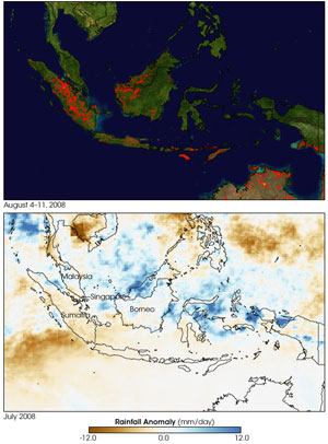
NASA satellite imagery released Tuesday reveals hundreds of “hot spots” burning in Sumatra, Kalimantan (on the island of Borneo), and southern Papua (on the island of New Guinea). The fires are set annually by landowners seeking to clear scrub and forest for the establishment of plantation crops, especially oil palm, which is used for making palm oil. In dry years the fires can burn for months, spreading into pristine rainforest areas and releasing large volumes of greenhouse gases into the atmosphere.
 The Moderate Resolution Imaging Spectroradiometer (MODIS) sensors flying on both the Terra and Aqua satellites detect fires by the heat they produce. Fire locations from MODIS for the week of August 4, 2008, are marked with red dots in the image above. The fire locations are overlaid on the NASA Blue Marble background. Officials were concerned that fires during the 2008 season could be more intense than normal because the dry season had been especially dry. The lower image confirms the drought. Made with data collected by the Tropical Rainfall Measuring Mission (TRMM) satellite, the image shows rainfall measurements for July 2008 compared to average measurements. Areas that received more rain than average are blue, while regions that received less rain are brown. Sumatra and southern Borneo were dry through the month. NASA images created by Jesse Allen, using fire data provided courtesy of the MODIS Rapid Response team, and TRMM rainfall data from the TRMM Science Data and Information System at Goddard Space Flight Center. Caption text by Holli Riebeek. |
AFP reports the number and intensity of fires this month has led authorities to declare the official start of the fire season in Indonesia. Officials are worried that fires could be worse than average this season due to the unusually dry year.
The fires will be closely monitored by Indonesia, its neighbors, and environmentalists due to the wide-ranging impacts of previous burning seasons. Fires in some years have caused tens of billions in health and economic damages while releasing as much as two billion tons of carbon dioxide. Fires in peat swamps are a particularly large source of emissions.
Under an agreement with Singapore and Malaysia, Indonesia has pledged to reduce the number of hotspots by 50 percent by 2009, 75 percent by 2012, and 95 percent by 2025. 144,000 hotspots were recorded in Sumatra in 2006, although the number feel to 35,000 in 2007 due to wetter conditions.
NASA reports that the environmental group WWF will be using MODIS satellite data to track the Indonesian government’s progress in controlling fires. MODIS data will be provided via the University of Maryland’s Fire Information for Resource Management System (FIRMS), an alert system that tracks hot spots in real time.
Related
Fire monitoring by satellite becomes key conservation tool:
An interview with GIS experts at CI and the University of Maryland March 27, 2008
Remote sensing is increasingly used as a tool for conservation management. Beyond traditional satellite imagery popularized by Google Earth, new sensing applications are allowing researchers located anywhere in the world to track fires, illegal logging and mining, and deforestation in some of Earth’s most isolated regions using a computer or handheld device. The Fire Alert System and FIRMS are two examples of applications that harness the power of satellites to deliver key data to conservation managers. Developed by Madagascar’s ministry of Environment, the International Resources Group, Conservation International using data from the University of Maryland and NASA, the Fire Alert System enables near real-time monitoring of fires anywhere on the island of Madagascar, a hotspot of biological diversity.


