- Media coverage of the effectiveness of UAVs in reducing wildlife poaching typically lacks supporting data — endurance and detection capability are their main limitations
- UAVs are just one component of a successful anti-poaching strategy
- Know your mission: deterrence, detection or response?
On the week of October 9th, a 10-man ranger patrol team was ambushed by wildlife poachers equipped with heavy artillery as they searched for an elephant tracking collar in Garamba National Park, Democratic Republic of Congo. Most of the unit escaped, but four men were killed in the attack, bringing the ranger death toll in Garamba to eight just this year. As similar stories play out across Africa, it’s easy to see why reserve managers have turned to military technology, including drones, to combat poaching of high-value wildlife.
Drones to the Rescue?
The use of drones, a.k.a. Unmanned Aircraft Systems (UAS) or Unmanned Aerial Vehicles (UAV), is among of the most sophisticated of the proposed solutions to the poaching crisis, and certainly the headline-grabber. Conservationists have called for deployment of UAS’s to the front lines of the poaching crisis, in order to enhance surveillance of protected areas and detection and pursuit of elephant and rhino poachers.

Recent press coverage on the transformative nature of UAS’s to protect wildlife, however, is often misleading or thin on evidence that the devices work as intended. Unmanned Aerial Systems are complicated, and reporters are not UAS experts; reports by manufacturers of successful field applications are frequently unsubstantiated by data. These rarely consider that the deterrence resulting from applying a novel technology is likely to be short-lived, once poachers recognize the UAS’s shortcomings. These claims have thus generated confusion and unrealistic expectations, as most advertised systems have neither the endurance to effectively monitor vast areas nor the equipment (sensors, long-range real-time camera feeds, etc.) to detect and assist in the apprehension of poachers.
A UAS – which includes not only the drone(s) but also the accompanying camera and other sensors, ground support equipment for launching and landing, communication system, replacement batteries and spare parts, and even training – is just one component of a complete anti-poaching strategy, including ranger teams, communication, and ground sensors. The UAS alone will not stop poaching.
Assessing the effectiveness and viability of the system being presented requires asking a few critical questions, first of your team and then of the UAS / tech manufacturer, which online reports suggest are raised only infrequently.
Asking the right questions
Until a systematic evaluation of the value added by applying UAS technologies to anti-poaching efforts is available, we offer a series of InFrequently Asked Questions and answers. We hope they will help wildlife managers and donors to understand what is needed and assess the feasibility and likely effectiveness of a given UAS deployment in suppressing poaching. They have been developed based on years of experience (Nir Tenenbaum is an experienced analyst of defense and security systems) analyzing defense and security systems for military and wildlife conservation clients in many countries.
Please read Demystifying Drones, Part I for some basics on UAS use for anti-poaching and check the “UAVs/drones” Forum on wildtech.mongabay.com, where we answer or seek answers to your questions from guest members.
The most critical and often overlooked first step in deciding on a UAS, or any new technology, is to define your group’s mission. What are you trying to accomplish by deploying the UAS?
Based on the mission – as defined by the user – this decision framework aims to clarify the realistic specifications that a system should meet. It also presents preliminary evaluation questions that will help you to assess the use of UASs in your mission and to think critically about a manufacturer’s or user’s claims. If your mission is to help an ongoing UAS-assisted program scale up its efforts, you will want to consider additional criteria.
Defining your mission in deploying UASs
- What is the mission?
The UAS mission is seeking to…
- Deter poachers from entering the park
- Detect poachers prior to or during entrance into the park
- Respond to a suspected poaching or criminal event in progress and assist in apprehension
If you answered only A. Using a UAS as part of an integrated strategy to combat poaching may initially discourage poachers from entering by creating an illusion that the UAS has a high probability of detecting them. However, unless the system actually helps to apprehend them, the deterrence results will likely be temporary.
If you hear assertions that a UAS has deterred poaching in an area, you should ask whether the cessation of poaching was due to actual apprehensions; otherwise, the cessation may not last. Such statements should be backed up by quantitative data that show that using the UAS continues to dissuade poachers.
Deterrence is a key part of anti-poaching effort; however, the presumed deterrence effect of flying drones in an area relies on the connection between their presence and apprehension. The efficacy of a UAS as a deterrent can be enhanced by combining it with a visible ground-based detection system (cameras, patrols, etc) and by at least occasional recognizable results (i.e. detections and apprehensions).
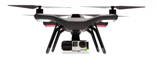
If you answered A and B. You are likely seeking a Preventative-level System. These systems need to patrol almost constantly to effectively detect poachers before or as they enter the protected area and before they have made a kill. Depending on the specific needs of the site, the system would include one or more UAVs with adequate endurance and range (i.e. 2-3 hours per flight, or 50-100 km per flight in a small reserve) and a series of high-quality sensors – including a gimbaled infrared camera to detect people at night – on board.
These requirements present two challenges: UAS endurance and detection capability.
1. UAS Endurance, or flying time, and the associated range are greater among fixed-wing UAVs (detailed in Table 1) than multi-copter UAVs. Military-grade systems tend to use fixed-wing UAVs as they can count on substantial resources and training to support the longer flight time they provide.
However, fixed-wing UAVs do not hover, and they are harder to control and return to a spot where a target was detected. A stabilized gimbaled payload system keeps the attached camera stable, allowing it to stay focused on that spot, even as the UAV is moving.
A second limitation related to distance is that of the live video link, which uses substantial energy so may not function beyond a certain distance from the operator.
Sample levels of features found at different price levels of Unmanned Aircraft Systems*
| Feature | $5,000 system (Basic Response) | $50,000 system (Advanced Response) | $500,000 system (Preventative)** |
| Flight time | 10-20 min | 20-60 min | 2-5 hr |
| Flight distance | 0-500 m | 1-3 km | 2-80 km |
| Flight speed | Slow | Slow-Medium | Medium |
| Take-off | Manual | Manual | Manual/System |
| Landing | Belly | Belly/System | System |
| Gimbal | No | No/Yes | Yes |
| Camera quality | Low | Low | Medium |
| Infrared sensor | None | Low quality | Low/med quality |
| Other sensors | None | None/Tag | Possible |
| On-board processing | None | None | Possible |
| Components | Off-the-shelf | ||
| Other | Crash more easily |
*These price categories pertain to purchase of an Unmanned Aerial System, not just the “bird.” The UAS includes a station, communication, payloads, spare parts, GSE (ground support equipment, like parachute or catapult), batteries (replace after 1 year), training, and probably multiple “birds,” given their probably lifespan of < 1 year. They presume regular use of ~2-7 flights per week.
**One year of operation of a fully equipped and functioning Preventative System can cost from US$250,000 to $500,000 per UAV, which is out of the range of nearly all civil society organizations, as well as most forest and wildlife agencies.
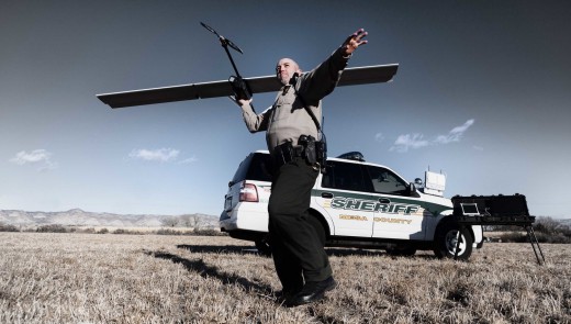
2. Detection capability: Equally important for detection is the challenge for the human eye to consistently and accurately scan the full area being filmed at the speed with which even a small UAV is moving. Reliable automated real-time on-board processing of images to detect specified types of objects (e.g. people) is still in the development phase, and manual scanning of the area below any UAV is like, as one expert put it, looking through a straw or pinhole at a moving target below.
Moreover, if a UAV is flying at 22 meters per second (80 kmh or 50 mph) and the distance visible from a fixed camera lens is 250m on each side (500m total width), the operator must scan and process more than a hectare (2.5 acres) of land every second, often from an image on the screen of a smartphone or tablet. A gimbaled camera can remain focused on the object detected, even though the UAV is in constant movement. While a high-quality image and solid stabilizing gimbal make for more accurate image processing by the operator, the constantly moving platform remains a challenge.
The process is most effective when operators fly slowly enough to make viewing comfortable, have a high-quality, gimbaled (fixable) image, and use a map to know where they have just flown. This labor-intensive process highlights the cost of having the trained operator working at night, a cost that is sometimes overlooked.
A slower-moving, multi-copter drone can hover at the spot of detection or return to it quickly but lacks the flight time needed to survey even a small reserve and then follow a suspected intruder. While the effectiveness of the on-board camera is highest at lower altitudes, the UAV must fly high enough to avoid detection and disturbance of wildlife. With either fixed-wing or copter UAVs, dense vegetation and a low-quality camera or InfraRed sensor (low resolution, with poor stabilization) will reduce the ability to detect a person moving below.
For these reasons, your team should have a plan of operation – how you will use your tools to detect and prevent the illegal event — to determine how many devices you will need, which device goes where and when, and how they work together. One strategy is to use intelligence to reduce the “dead time” of surveillance, when nothing is happening. Whether that intelligence comes from computer models, smart patrolling, or local informants, focusing UAS deployment in areas targeted by poachers will make its use more efficient and effective.
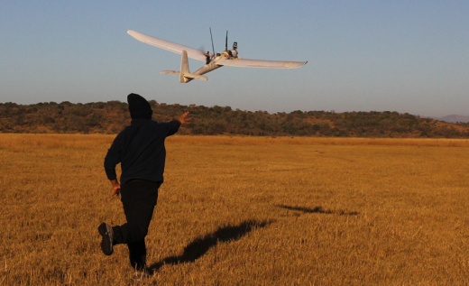
If you answered C. You are seeking a Responsive system with short-to-medium range and endurance (e.g. 1-3 km per flight, or 20-60 minutes per flight) with a gimbaled (stabilized) payload.
The system would be able to respond to a suspected poaching event but should not be used to routinely search for illegal human activity due to its still-limited endurance and flight range. It could effectively assist anti-poaching teams that have otherwise detected an incident as an eye-in-the-sky to inform tactical decisions and follow poachers from the scene. The system could include off-the-shelf, commercial components and start in price from $5,000, but improving flight time, durability, reliability over time and adding night vision capability can increase that up to $10,000, or even $50,000+.
A reliable UAS would have adequate flight time, camera quality, and spare parts to conduct its mission, could be launched daily, return home and be ready to go soon after, and function and be maintained easily without professional users.
Remember, your group’s mission – whether to prevent or respond to poaching incidents— should determine which type and model is best suited for a given anti-poaching deployment. If you are not sure, or if you are just beginning your exploration of potential uses of UASs, you might first want to familiarize yourself with UAS basics. There are plenty of forums and articles on general UAS use, as well as a few related to conservation, and we’ve assembled a few here to help get you started:
With UASs technology advancing so rapidly and each set of local conditions (e.g. vegetation type and height, available funding and personnel, poaching methods) unique, knowing one’s mission is key to asking manufacturers about the most important features, the next post in this series, and questions on alternative technologies.
Regardless of the anti-poaching mission, we maintain that the UAS should be viewed as part of an overall solution using multiple detection technologies – aerial and ground – and that the appropriate combination will depend on the specific characteristics of both the mission and the site (threats, terrain, personnel, etc).
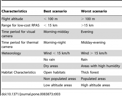
For example, this table, published as part of a study of UAS use for rhino anti-poaching work, indicates the most and least favorable conditions for deploying a UAS costing roughly € $13,750 (US $14,770), including three cameras, ground control station, and a single UAV. Flight altitude that was low enough to detect humans with a visual camera was considered both unsafe and likely to disturb the rhinos, and most of their thermal images were too low quality to identify animal species.
In summary:
- It’s critical to know your mission – the ideal system varies depending on the conditions and the tasks you need to accomplish
- More expensive systems have more rugged, longer-lasting components and better quality imagery
- The full system is needed, though even that is not enough by itself to stop poaching
- Most UAS lack the endurance and equipment to detect poachers and prevent them from finding their targets
- A responsive system integrated with ground and other sensors is most likely to be effective.
Nathan Hahn, Sue Palminteri, and Max Ciaglo helped to research, write, and edit this series.
UAS Glossary
Drone – The most common and most incorrectly used term. Originating from the male honeybee, it was used to refer to the first-generation of unmanned aircrafts that were used mainly as “simple” flying targets for practice and experimental purposes. As systems evolved to modern-day autonomous levels, the continuous use of the term does a disservice to their character, capabilities and activity.
Fixed-wing: A term used to describe UAV’s with a permanent wing assembly, like an airplane, requiring continual forward motion (i.e. cannot hover). It commonly provides longer endurance and higher payload capacity, so is designed for longer-range missions.
Gimbal – A stabilizing platform that can pivot and thus allows the rotation of a supported object (a UAV’s payload) on at least one (often 3) designated axes, independent from its support (the platform).
Multi rotor (copter): A term used to describe UAVs that use multiple rotors to provide both vertical lift and horizontal motion. These rotors, similar to single-rotor helicopters, allow the UAV to hover and provide simpler operation and stable images from attached cameras. Commonly used for shorter-endurance and shorter-range missions.
Payload – Equipment carried by the UAV that is utilized to perform a mission (e.g. camera, packages) and not directly related to flight, control or navigation. Higher-quality sensors may require a larger UAV
Platform – A simple term used by professionals when referring to the aerial component of the UAS (“the bird”), commonly referring to the unmanned aircraft that is flying and carrying the components necessary for flight and mission.
RCA/RC/Radio Controlled Aircraft — A small, operator-controlled aircraft, based on hobbyist-level platforms, that can at times include basic semi-autonomous capabilities and carry small payloads. RCA’s are directly controlled by a person via handheld consoles in direct line of sight and not via an on-board controller, software, or autonomous hardware. The capacity for control is typically limited to flight parameters only, with no autonomous commands, operational oriented design, automatic backup, or safety systems, and they normally include only uplink commands. Some independent manufacturers attach external independent payloads to RCAs, wrongfully designating them as UAVs even though they do not adhere to RPA/UAV characteristics.
Real-time system – One that transmits data, such as images, video, or other remotely sensed information, immediately from the UAV to the operator, allowing real-time search, detection and response.
RPA – “Remotely Piloted Aircraft”: a RPA is the formal term referring to the platform itself, indicating, in contrast to the RCA, that it is a remotely piloted semi or fully autonomous aircraft, via an onboard software and hardware. Generally RPA’s are reusable aircrafts designed to perform a mission with various payloads and not just for “flight” experience. The definition of the term “piloted” vs. control is essential, referring to command via a semi/full autonomous onboard software and hardware while normally including a conscious ground operator, reviewing flight, sensors, payload and mission data, with uplink commands and ordinarily downlink (or onboard) data. Capabilities and quality vary greatly.
UAS – Unmanned Aircraft System. The coordinated set of modules, including the aerial semi- or fully autonomous vehicle(s), payloads, ground control and communication station, predesigned by the manufacturer to act as a complete operational unit or system to perform a mission.
UAV – Unmanned Aerial Vehicle – The older term for RPA’s. An advanced semi- or fully autonomous remotely piloted aircraft (RPA) – it does not carry a human operator and is controlled from the ground via its autopilot mechanism. The UAV can be preprogrammed for both flight and payload operations prior to launch (non-real-time) or during flight (real-time). It can be operated out of line of sight and at altitudes where a person on the ground cannot readily see it. – Click here for details.


