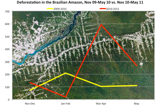
Deforestation in the Brazilian Amazon, November 2009-May 2010 vs November 2010-May 2011 (sq km). Background image: deforestation near Itaituba, Brazil. Courtesy of Google Earth
Satellite data released today by the Brazilian government confirmed a rise in Amazon deforestation over this time last year.
Brazil’s National Institute for Space Research (INPE) says that deforestation during the month of May amounted to 268 square miles, a rise of 144 percent over May 2010. 35 percent of the clearing occurred in Mato Grosso, the state where agricultural expansion is fast-occurring.
INPE’s announcement comes two weeks after Imazon, an NGO, said deforestation in May 2011 was 72 percent higher over May 2010. The discrepancy in the estimates result of different methodologies in analyzing satellite data. Both INPE and Imazon have near real-time deforestation monitoring capabilities.
Month-to-month deforestation estimates using this systems tends to be highly variable, but the trend over recent months seems to indicate a substantial increase in deforestation over last year, which was the lowest since annual record-keeping began in 1988.
Deforestation in Brazil is typically measured on a calendar year ending in July, when cloud cover in the region is at a low point and higher resolution satellite analysis is possible. Deforestation usually peaks in the Brazil Amazon during the dry season which runs from July through October.
Deforestation has steadily declined since 2004 due to a several factors including macroeconomic trends, improved law enforcement, new protected areas, pressure from NGOs, and private-sector initiatives. But environmentalists and scientists fear that proposed changes to Brazil’s Forest Code, which requires landholders in the Amazon to maintain 80 percent forest cover on their lands, could trigger a reversal in deforestation rates.

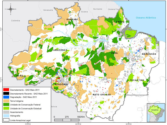
Deforestation in May 2011.
The analysis by Imazon earlier this month suggests that the Forest Code debate may be a factor in rising deforestation. It found a 363 percent increase in forest degradation — logging and burning of forest that typically precedes deforestation — over the past 10 months, reaching 6,081 sq km. Most of the degradation occurred in major agricultural states: Mato Grosso (42 percent of degradation in May), Para (27 percent), and Rondônia (22 percent). The majority of deforestation also took place in these states: 39 percent in Pará, 25 percent in Mato Grosso, and 21 percent in Rondônia.
More tellingly, two-thirds of clearing occurred on private lands, which are most likely to benefit from changes in the Forest Code. Private landowners — particularly agroindustrial interests — have been pushing Forest Code reform, while small landowners and indigenous groups have generally opposed changes. Accordingly, deforestation over the past 10 months in indigenous territories and areas of agrarian reform (usually small-holder zones) amounted to only 12 percent and 1 percent, respectively. 22 percent of deforestation in May 20111 occurred in conservation areas.
Deforestation in May was highest in the municipality of Altamira, Para, where the controversial Belo Monte dam is to be constructed. Critics say the project will drive deforestation in surrounding areas as well as inundating large areas of forest and displacing thousands of indigenous people. Altamira accounted for 13 percent of total deforestation. It was followed by Porto Velho, Rondonia (8 percent), which serves as a key hub for the newly paved Trans-Oceanic Highway that links the heart of the Amazon to Peruvian ports. The highway will facilitate shipping of agricultural and timber products from the Amazon to China.
Deforestation in the Brazilian Amazon is typically driven by industrial agriculture and land speculation. More than 70 percent of deforested land ends up as cattle pasture. High commodity prices typically create incentives for deforestation.
Related articles


