New map shows paths of historic hurricanes
New map shows paths of historic hurricanes
mongabay.com
November 7, 2006
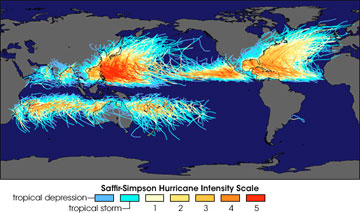
NASA posted a new historic hurricane map showing all storm tracks available from the National Hurricane Center and the Joint Typhoon Warning Center through September 2006. The map was created by Robert A. Rohde of Global Warming Art.
A news release explaining the image appears below.
NASA Earth Observatory: Historic Tropical Cyclone Tracks
Like streamers of splattered paint, the tracks of nearly 150 years of tropical cyclones weave across the globe in this map. The map is based on all storm tracks available from the National Hurricane Center and the Joint Typhoon Warning Center through September 2006. The accumulation of tracks reveals several details of hurricane climatology, such as where the most severe storms form and the large-scale atmospheric patterns that influence the track of hurricanes.
Over time, the repeated passage of strong storms through the same regions creates solid swashes of color: bright red in the Western Pacific near the Philippines, where numerous Category 5 storms have traveled; orange and gold in the Caribbean and the Gulf of Mexico, where Category 3 and 4 storms often pass. The blues and light yellows reveal storms in a weaker state: near the equator, in their first stages of development; over land, as they run out of steam; in the mid-latitudes, where they encounter cooler waters.
|
Image by Robert A. Rohde, Global Warming Art. Click to enlarge |
The absence of hurricanes at and very near the equator reveals another important factor in hurricane development: the Coriolis force. The Coriolis force results from the Earth’s spherical shape and its rotation. The force keeps air from moving in a straight line across the surface of the Earth. Instead, the Coriolis force spins moving air to the right in the Northern Hemisphere and to the left in the Southern Hemisphere. The Coriolis force is strongest near the poles, and zero at the equator. Although frequent thunderstorms do occur at the equator, the air rushing into the low-pressure centers of these storms doesn’t get the needed “spin” from the Coriolis force, and so the storms don’t develop the large-scale rotation that sets them on the path to becoming hurricanes.
Another obvious feature is the lack of tropical cyclones in Southwest Pacific and South Atlantic Oceans. To the west of South America, the Peru Current snakes northward along the coast of Chile, Peru, and Ecuador, bringing cool water from southern polar regions. The cool current keeps waters from reaching hurricane-friendly temperatures. A similar cold current, the Benguela Current, flows up the western coast of South Africa, past Namibia and Angola, keeping those waters too cool for hurricanes as well. The South Atlantic off the east coast of Brazil isn’t favorable for hurricanes for a variety of reasons, including prevalent wind shear (variation of wind speed or direction at different altitudes.) In 2004, a rare—perhaps unique—tropical cyclone formed in this region, eventually making landfall in Brazil; the track of this storm, Hurricane Catarina, stands alone in the South Atlantic.
The map also reveals the general atmospheric “steering” influences on hurricanes. In the tropics, the storms move with the prevailing easterly winds that occur in both hemispheres. Farther from the equator, in the mid-latitudes, westerly winds are more common. Storms that have survived to these latitudes often swing back to the east before falling apart.
To learn more about hurricane formation, climatology (including the relationship between global warming and hurricanes), and NASA’s hurricane research activities, please read the Earth Observatory’s newly updated fact sheet, Hurricanes: The Greatest Storms on Earth.


