- Researchers analyzed a suite of satellite imagery products and found much greater deforestation than expected since 2000 in the highlands of Southeast Asia.
- Much of the 82,000 square kilometers (31,700 square miles) they estimate to have been developed into croplands in the region’s highlands reflects previously undocumented conversion of forest, including primary and protected forests, to agriculture.
- Through a sample-based verification process, the authors found that 93 percent of the pixels from areas allocated to areas of net forest loss by the authors’ model were confirmed as net forest loss, and 99 percent of the pixels delineated as other areas were accurately labelled as non-net forest loss.
- The findings contrast with previous assumptions about land-cover trends currently used in projections of global climate change and future environmental conditions in Southeast Asia.
Deforestation in Southeast Asia is greater than previously recorded, according to authors of a recent analysis of satellite image data. The researchers highlight in particular the extensive but previously unrecorded conversion of higher-elevation forest to cropland.
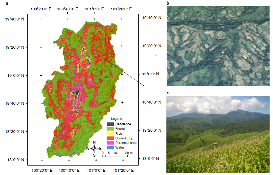
By combining multiple streams of high- and medium-resolution satellite imagery, the multinational research team calculated that Southeast Asia lost 82,000 square kilometers (31,700 square miles) of forest to croplands between 2000 and 2014.

The team used publicly available global maps of tree canopy cover for each year in the 21st century created from Landsat medium-resolution imagery from the Global Land Analysis and Discovery GLAD lab (Hansen et al 2013) to quantify forest loss each year from 2000 to 2014.
The Landsat data, based on light reflectance levels, has a resolution of 30 meters (98 feet) and cannot distinguish mature tree crops, such as oil palm and rubber plantations, from forest. So the research team included areas with tree crops taller than 5 meters (16 feet) in their definition of forest. The researchers defined croplands as areas planted with annual or small perennial crops, such as corn, rice, coffee, and tea. These plants are shorter than the 5-meter threshold, and so did not appear as forest in this dataset.
“We cannot use satellite imagery to tell a mature tree crop plantation from forests,” lead author Zhenzhong Zeng, from the Department of Civil and Environmental Engineering at Princeton University, told Mongabay-Wildtech. “Tree crop has been counted as forest by Hansen [and colleagues], and also in our study. It means that, if you count it as agriculture, there is even more deforestation and agricultural expansion.”
The research team defined deforestation using what they labeled net forest loss areas (NFLAs): groups of pixels in the images that were deforested after 1999 and remained deforested after 2014.
To assess the accuracy of this straightforward method of quantifying loss of tree cover canopy, they visually interpreted 5,000 sample pixels in Landsat 7 images from 1999 to verify their forest cover. They also visually interpreted these same pixels in Google Earth / Digital Globe and Planet high-resolution images (of 5 meters or finer) from 2014 (or thereabouts, to capture cloud-free images) to determine whether the NFLAs had been converted to crops or other land use.

Through their sample-based verification process, the authors found that 93 percent of the pixels from areas allocated to NFLAs were confirmed as net forest loss, and 99 percent of the pixels delineated as non-NFLAs were accurately labelled as non-net forest loss.
“I believe the method is easy to replicate, as all datasets are open to the public, and the methods have been well described in the paper,” Zeng said. “[It] is a labor-intensive process. It cost me a month just to visually interpret the satellite imagery.”
Unexpectedly high deforestation in highland, as well as lowland, forests
Once they determined the spatial patterns of cropland expansion since 2000, they compared their deforestation patterns to other land-cover datasets, including the global land-cover reconstructions used in Intergovernmental Panel on Climate Change (IPCC) climate simulations.

“The most striking result in our analyses,” the authors state in their paper, “is that these widely used land-cover-change products do not account for the rapid forest loss in SEA during the twenty-first century, particularly within highland regions of mainland SEA, where cropland expansion has been the key driver.”
The scientists estimated that between 2000 and 2014, Southeast Asia lost 293,000 square kilometers (113,100 square miles) of forest, more than 11 per cent of the total forest cover in 1999. That’s an area the size of Italy, and represents 57 percent more loss than current estimations of deforestation made by the IPCC, said Zeng in a statement.
Of this, 200,000 square kilometers (77,200 square miles) of forest loss occurred in lowland forest and the rest in the highlands, most of which was conversion to cropland. In fact, the visual interpretation of the sample pixels indicated that, across Southeast Asia, 94 percent of forest loss in lowland pixels and 88 percent in highland pixels resulted in cropland.
For highland areas, this corresponds to roughly 82,000 square kilometers developed into croplands. A “substantial portion” of this reflects clearing of mature forests. Forests cleared for growing crops occurred mainly in the higher elevations in mainland Southeast Asia and primarily in the lowlands in maritime areas, corresponding roughly to Malaysia and Indonesia.

The researchers repeated the analysis with another 30–meter-resolution product from the Global Land Cover Facility (GLCF), which includes maps of forest cover change from 1990, 2000, 2005 and 2010 created using algorithms different from those of the GLAD maps. The cloud-free pixels in the GLCF maps showed similar forest loss patterns, including widespread forest loss in the highlands of mainland Southeast Asia.
Forest at different elevations
Highland ecosystems support unique plants and animals. The lower temperatures and steeper slopes of higher elevations, which the study defined as higher than 300 meters (985 feet) above sea level, may limit crop yields, so most agriculture in Southeast Asia has historically occurred in the lowlands.
In fact, the authors state in their paper, projections by the United Nations Food and Agriculture Organization (FAO) of minimal net expansion of croplands in Southeast Asia’s highlands reflect a general view that clearing highland forest for farming is not economically viable.
The IPCC analyses have incorporated FAO crop growth predictions that forest and tree-dominated land cover, including tree plantations, will persist in Southeast Asian highlands.
But the current study raises questions about these assumptions, with its findings that forested areas are being converted for cropland at higher elevations as well as in known lowland regions.

The authors suggest that their forest loss estimates are greater than those of the IPCC in large part because their analysis incorporates the conversion of higher-elevation forest in mainland Southeast Asia.
They also indicate that the spread of highland agriculture since 2000 is likely to continue. They suggest that the recent rapid increase in cropland expansion in higher-elevation areas, despite sub-optimal conditions, reflects the scarcity of land: most of mainland SEA’s lowland forests had already been cleared for agriculture by the year 2000. In contrast, maritime Southeast Asia — principally Malaysia and Indonesia — still retained large areas of lowland forest until recently.
Importance of accurate tree canopy cover data
The study’s findings contrast substantially with projections of land-cover trends that decision-makers currently use to predict future climate change, terrestrial carbon storage, biomass, biodiversity, and land degradation. Moreover, although some crop trees contribute to maintaining carbon stock, they don’t support the high biodiversity of complex tropical forest systems.

The authors state that their study’s use of 30-meter-resolution Landsat imagery verified by inspection of the 5,000 high-resolution sample pixels improves upon previous global maps that relied on both lower-resolution data sets and national agricultural statistics.
The findings raise uncertainty about several assumptions used to make global climate change projections, and suggest the impacts of forest clearing may be greater than previous predictions. Forests absorb atmospheric carbon, and burning forests contribute carbon to the atmosphere. IPCC estimates are widely used for creating policy and setting benchmarks of carbon emission reductions. An accurate estimation of forest cover is therefore critical in assessing the impacts of human activity on climate change.

“Incorporating the most accurate portrayal of SEA’s highland land cover and potential future forest conversion into global climate models should be an immediate priority,” the authors write.
In addition to its impact on carbon sequestration, the conversion of forests in highland ecosystems to cropland harms unique highland plant and animal communities. Steeper slopes accelerate risks of soil erosion and runoff of agricultural pollutants, so it can also negatively affect soil retention and reduce water quality and quantity in the region.
Co-author Eric Wood, also from Princeton, echoed Zeng’s concern that farmers are clearing new areas from the highland forests of mainland Southeast Asia. “These forests,” Wood said in a statement, “are an important source for sequestering carbon as well as critical water sources for adjacent lowlands.”
Citation
Zeng, Z., Estes, L., Ziegler, A. D., Chen, A., Searchinger, T., Hua, F., … & Wood, E. F. (2018). Highland cropland expansion and forest loss in Southeast Asia in the twenty-first century. Nature Geoscience, 1.


