
- Participatory mapping is increasingly used in conservation to bring local knowledge, land use, cultural values and community priorities into spatial planning.
- A new review of 398 studies finds that the field has grown quickly, especially over the past decade, but still lacks consistent standards for methods, ethics, data ownership and evaluation.
- Cases such as Massaha in Gabon show how community maps can challenge global or official datasets that make lived-in forests appear empty or unclaimed.
- The approach is most useful when maps are tied to real decisions, clear governance processes and safeguards for the people and places being mapped.

For many conservation decisions, the most contested question is also the most basic: what belongs on the map?
A forest may appear on a satellite image as intact canopy. To people who live near it, the same forest may be a hunting ground, a burial site, a medicine cabinet, a route to school, a refuge for wildlife, or a place where patrols have become threatening. A reef may be mapped by scientists as coral cover, fish biomass, or thermal stress. Fishers may know it by currents, seasons, spawning sites, customary rules and the places where conflict is likely. Conservation planning increasingly depends on spatial data. Participatory mapping asks who gets to produce that data.
A new review in Conservation Science and Practice, by Michael Kowalski and colleagues, offers a useful stocktake of the field. The authors define participatory mapping as a collaborative process in which participants and cartographers co-develop maps representing local knowledge, experiences and preferences about a place. Their review covers 398 peer-reviewed studies, tracing how the method has been used across conservation science and practice. It also makes clear that a field built around community knowledge still lacks consistent standards for how that knowledge should be gathered, interpreted, protected and used.
The premise is simple enough. Conservation maps have long been drawn from above: through satellite imagery, expert surveys, species-distribution models, government zoning and protected-area boundaries. These tools are indispensable. They can reveal forest loss, habitat fragmentation, coral bleaching or fire risk at scales no village meeting can cover. They also tend to miss how people actually use and value landscapes.

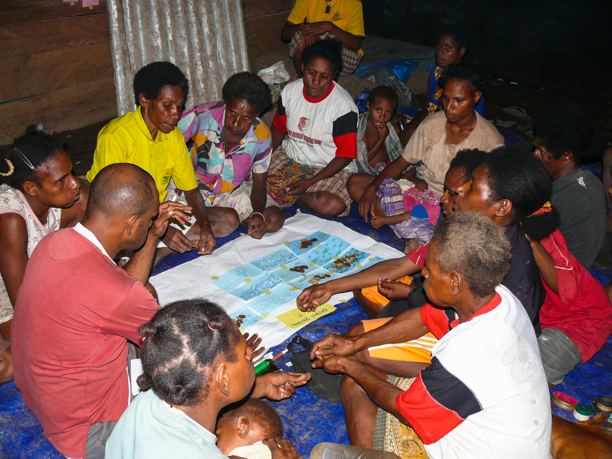
Participatory mapping works closer to the ground. In some projects, community members draw on paper maps or sketch places from memory. In others, they place points, lines or polygons on digital platforms. Some exercises involve large online surveys; others depend on a small group of fishers, herders, forest users or Indigenous leaders. The method can be used to locate fishing grounds, grazing areas, wildlife corridors, sites of cultural importance, ecosystem services, conflict zones, invasive species, disease risks or places where conservation restrictions may create hardship.
This makes participatory mapping a bridge between two conservation needs that are often treated separately. One is technical: better information about where ecological and human systems overlap. The other is political: greater legitimacy for decisions that affect people’s land, livelihoods and rights. A map can become evidence, but also a forum. It allows people to point to a place and say: this matters, and here is why.
The approach has deep roots. Participatory mapping emerged from rapid rural appraisal, participatory action research and later public participation GIS. Robert Chambers, one of the central figures in participatory development, framed the essential question bluntly: whose map, who is empowered, who is disempowered, who gains and who loses? That question remains the center of the field. A participatory map is never just a technical product. It reflects choices about who was invited, who felt safe speaking, who controlled the process, what was recorded, what was left off and who later had access to the result.
Kowalski and his co-authors show a field that has grown quickly, with conservation-related participatory mapping efforts rising steadily from 2012 and peaking in 2019 before falling during the pandemic. The studies they reviewed span 13 domains, from ecosystem services, natural resource management, conservation values, land-use planning and species distribution mapping to fisheries management, environmental justice, climate change, human-wildlife conflict, conflict resolution, introduced species and disease mapping. Their review found mapping efforts in 102 countries and on every continent, though the authors caution that their focus on English-language, peer-reviewed publications leaves gaps in the record. The pattern also varies by region. In North America and Australia, studies have often focused on conservation values, species distributions and land-use planning. In South America, Africa and Asia, they more often center on natural resource management. In Europe, ecosystem services have been the main focus, with conservation values and fisheries management also prominent.

These patterns reflect the different problems the method is being asked to solve. In marine settings, participatory mapping can reveal where people fish, gather, dive or depend on reefs in ways that formal datasets rarely capture. Shankar Aswani and Matthew Lauer’s work in the Solomon Islands showed how Indigenous ecological knowledge and artisanal fishing data could be incorporated into GIS to help design marine protected areas. In Hawaii, Arielle Levine and Christine Feinholz used participatory GIS to document human coastal and ocean uses in priority coral-reef management sites. Managers valued the process not only for the maps, but for identifying stakeholders and building engagement around future decisions.
On land, participatory mapping has often been used to locate social values that are hard to capture through biophysical data. A wetland may be important for water regulation, recreation, cultural identity and a community’s sense of continuity. A park may be valued differently by visitors, nearby residents, Indigenous groups and agency staff. Work by Christopher Raymond and colleagues in Australia’s Murray-Darling Basin mapped community values for natural capital and ecosystem services, showing that values varied by place and subregion. Greg Brown and collaborators later argued that mapped place values are often relationship values: they show how people are connected to specific landscapes, not simply how useful those landscapes are.

This matters for a conservation field increasingly interested in precision. Recent discussions of “precision conservation” and place-specific strategies emphasize targeting interventions where they are most likely to work. Participatory mapping adds a missing layer to that logic. A model may identify the best place for forest restoration based on habitat connectivity or carbon storage. Local mapping may show where restoration would conflict with grazing, where past projects failed, where tenure is disputed, or where a community already protects a spring or sacred grove. The most efficient intervention on paper may be unworkable on the ground.
An example can be found in northeastern Gabon, where the community of Massaha mapped Ibola Dja Bana Ba Massaha, a forest south of the village whose name means “the reserve of all Massaha’s children.” On global maps, much of the area appeared as intact forest. In administrative terms, it lay within a logging concession. Massaha’s own maps told a different story. Through oral histories, participatory GIS, GPS fieldwork and community review, residents documented ancestral villages, sacred sites, a sacred lake, forest clearings and the spread of logging roads. The resulting map became evidence in a political claim: the community asked the government to remove the forest from the concession and recognize it as a community conserved area. In this case, participatory mapping was not an add-on to conservation science. It was the means by which a forest that looked empty on official maps became visible as a lived and governed place.

The Massaha case also shows why the word “participatory” needs scrutiny. The community was not simply supplying local color to an outside analysis. Its members helped define the territory, reviewed the data and used the map in a campaign over the forest’s future. The paper’s authors compared Massaha’s biocultural maps with colonial, post-colonial and global land-use maps, finding that official and historical sources had missed much of the community’s occupation and cultural geography. The difference was not just technical. One set of maps made the forest easier to treat as concession space. Another made visible the history and authority of the people who claimed responsibility for it.
This does not make local knowledge automatically correct or complete. Participatory maps can be biased by who participates, how questions are framed and what people are willing to disclose. A workshop dominated by men may fail to record places important to women. Digital mapping may exclude elders or poorer households. Public mapping of sacred sites, illegal resource use or endangered species locations may expose communities or wildlife to harm. Some groups may want their knowledge made visible to support land claims. Others may want it withheld. The same act of mapping can protect rights in one setting and create risk in another.
Kowalski and colleagues are especially useful on this point. They warn that participation can become extractive when researchers or agencies collect local knowledge without changing decisions, sharing control or measuring outcomes. A map without follow-up can raise expectations, divert resources, give authorities the appearance of consultation, or turn local knowledge into a tool for outside control. The authors argue that practitioners must attend to power imbalances, representation, scheduling, autonomy, confidentiality and mutually agreed deliverables, especially given conservation’s colonial history and continuing inequities.
The field also suffers from messy terminology. Public participation GIS, participatory GIS, volunteered geographic information, sketch mapping and mental mapping are often used inconsistently. Kowalski and colleagues suggest that researchers should describe what they actually did: the mapping medium, sampling design, recruitment strategy, participant demographics, prompts and representativeness. This sounds prosaic, but it is essential. Without such details, it is difficult to know whether a map represents a community, a stakeholder group, a set of experts, an online convenience sample or a few people who happened to attend a meeting.
The harder test is whether participatory maps change decisions. Here the record is thinner. Brown and Fagerholm’s review of participatory GIS for ecosystem services found strong potential for mapping cultural and provisioning services, but little evidence that mapped ecosystem-service data had been used in actual land-use decision support. Brown, Reed and Raymond reached a similar conclusion after two decades of place-values research: participatory maps can identify important human-environment relationships, yet their influence on land-use decisions remains limited. Agencies may lack incentives to use them. Officials may distrust lay knowledge. Powerful interests may still dominate planning.
Massaha is a reminder that the influence of a map often depends on what surrounds it: organization, legal strategy, alliances, political timing and persistence after the workshop ends. The map mattered because it became part of a wider claim over territory and governance. In many projects, that connection is weaker. Data are collected, a report is written, and the decision process continues much as before.
That finding should temper both enthusiasm and dismissal. Participatory mapping is not a shortcut to justice. It cannot by itself settle disputes over land, fisheries, protected areas or development. Nor can it replace ecological surveys, enforcement, legal reform or financing. Its value lies in making certain kinds of knowledge visible early enough to matter.

For practitioners, the starting point should be the decision itself. Use participatory mapping when spatial knowledge from affected people is necessary to make that decision well. Be clear about whether the goal is research, planning, negotiation, monitoring, rights recognition or conflict prevention. Decide in advance who will own the data, what will remain confidential and how the maps will feed into decisions. Treat the process as part of governance, not merely data collection.
The next stage of the field may depend less on better software than on better practice. Conservation already has more maps than most institutions can use well. What it often lacks is a disciplined way to connect mapped evidence with legitimate decisions. Participatory mapping can help do that, if it is used with care.
The map that results may look less tidy than one drawn from a satellite or a model. It may contain uncertainty, disagreement and knowledge that resists easy classification. That is part of its usefulness. Conservation happens in real places, among people with memory, dependence and claims. A map that cannot show that is incomplete, however precise it appears.
Banner image: A 2004 mapping expedition organized by the Trio and the Amazon Conservation Team in Suriname. Image courtesy of the Amazon Conservation Team.
Citations:
- Kowalski, M. B., Wilkinson, C. E., Wilmers, C. C., & Ocampo-Peñuela, N. (2026). A review of participatory mapping in conservation science and practice. Conservation Science and Practice, 2026, Article e70300. https://doi.org/10.1111/csp2.70300
- Sieber, R. (2006). Public participation geographic information systems: A literature review and framework. Annals of the Association of American Geographers, 96(3), 491–507. https://doi.org/10.1111/j.1467-8306.2006.00702.x
- Chambers, R. (2006). Participatory mapping and geographic information systems: Whose map? Who is empowered and who disempowered? Who gains and who loses? The Electronic Journal on Information Systems in Developing Countries, 25(2), 1–11. https://doi.org/10.1002/j.1681-4835.2006.tb00163.x
- Aswani, S., & Lauer, M. (2006). Incorporating fishermen’s local knowledge and behavior into geographical information systems (GIS) for designing marine protected areas in Oceania. Human Organization, 65(1), 81–102. https://doi.org/10.17730/humo.65.1.4y2q0vhe4l30n0uj
- Levine, A. S., & Feinholz, C. L. (2015). Participatory GIS to inform coral reef ecosystem management: Mapping human coastal and ocean uses in Hawaii. Applied Geography, 59, 60–69. https://doi.org/10.1016/j.apgeog.2014.12.004
- Brown, G., & Weber, D. (2011). Public Participation GIS: A new method for national park planning. Landscape and Urban Planning, 102(1), 1–15. https://doi.org/10.1016/j.landurbplan.2011.03.003
- Raymond, C. M., Bryan, B. A., MacDonald, D. H., Cast, A., Strathearn, S., Grandgirard, A., & Kalivas, T. (2009). Mapping community values for natural capital and ecosystem services. Ecological Economics, 68(5), 1301–1315. https://doi.org/10.1016/j.ecolecon.2008.12.006
- Spake, R., Jackson, E.E., Bullock, J.M. et al. Precision ecology for targeted conservation action. Nat Ecol Evol 9, 1102–1111 (2025). https://doi.org/10.1038/s41559-025-02733-4
- Ibola Dja Bana Ba Massaha, Ekazama Koto, S., Walters, G. M., Asatsi Mabo, H., Makala, F., Ndanga Azeon, P., Mabo, J., Mandoumilele, P. N., Hendje, J. P., Baza Djia, D.-D., Betotobeya, H., Ndongoabendje, M., Maïdji, E., Maloumambomba, S., Koumokoukou, D., Kotomoukaye, G., Mbengoy, F., Bobouagno, B., Bopounda, G., . . . Froese, G. Z. L. (2026). Community biocultural mapping reveals historical occupation and enables defense of African rainforests. Ambio. https://doi.org/10.1007/s13280-025-02334-2
- Brown, G., Reed, P., & Raymond, C. M. (2020). Mapping place values: 10 lessons from two decades of public participation GIS empirical research. Applied Geography, 116, Article 102156. https://doi.org/10.1016/j.apgeog.2020.102156
- Brown, G., & Fagerholm, N. (2015). Empirical PPGIS/PGIS mapping of ecosystem services: A review and evaluation. Ecosystem Services, 13, 119–133. https://doi.org/10.1016/j.ecoser.2014.10.007
Founder’s Briefs — Conservation effectiveness
A short thematic series of analysis and primers by Mongabay founder Rhett Ayers Butler.
Plenty of biodiversity data, but too few conservation answers
Precision conservation: the rise of place-specific strategies where protection works best
Birds are changing — and Indigenous memory is the longest record we have


