- The Indonesian government has launched a plan to cut down land and forest fire hotspots by nearly half, in part by protecting peat forests.
- The program, which calls for $2.73 billion in funding, aims to ensure that 121,000 square kilometers of land, a fifth of it peat forest, will be fire-free by 2019.
- The move comes as the government anticipates drier weather conditions than usual next year in perennial hotspot regions like West Kalimantan.
JAKARTA – The Indonesian government has unveiled an ambitious plan to nearly halve the number of fire hotspots in the country by 2019, in part through the restoration of degraded peat forests.
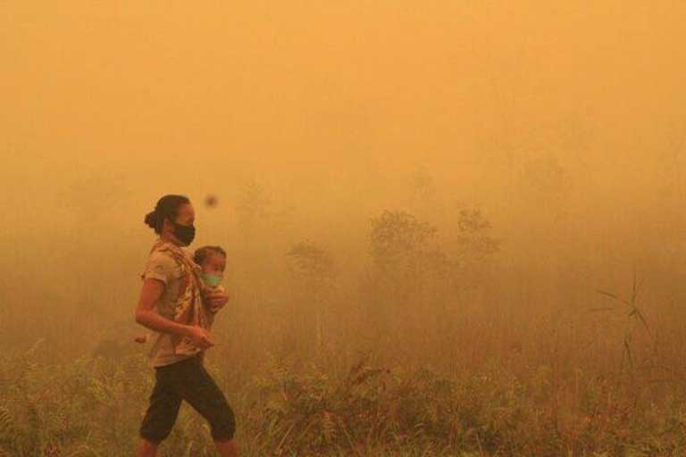
The fires are an annual occurrence, linked to the clearing of forests for logging and monoculture plantations. In recent years the problem has been exacerbated by the draining of peat swamps, which leaves them highly combustible.
Under the new plan revealed Tuesday by the Coordinating Ministry for the Economy, the government aims to tackle the fires through a two-pronged approach.
First is ensuring that the 24,000 square kilometers (9,266 square miles) of degraded peat areas slated to be restored by Indonesia’s peatland restoration agency (BRG) are not burned. Second is boosting prevention efforts in 731 villages in Sumatra and Kalimantan, the Indonesian portion of Borneo, identified as being historically prone to fires.
In all, the plan calls for the protection of 121,000 square kilometers (46,718 square miles) of land, which, if kept successfully free of fire by 2019, will reduce the anticipated number of hotspots by 49 percent compared to business-as-usual levels.

Five action plans
Because of its wide scope, the plan will involve multiple government agencies and require at least 39 trillion rupiah ($2.73 billion) in funding.
It comprises five action plans, the first of which is to provide economic incentives and disincentives. Each of the fire-prone villages, for instance, will be eligible for 300 million rupiah ($21,000) in funding if it manages to prevent land and forest fires for a full year. Concession holders, meanwhile, risk the revocation of their permit if found liable for fires on their land.
“This strategy is the most important [of all the strategies], in my opinion,” Environment and Forestry Minister Siti Nurbaya said on the sidelines of the launch of the plan.
The second action plan calls for empowering villagers and forest communities to prevent and tackle fires, while the third focuses on more stringent enforcement of existing laws and regulations on forest concessions.
Improving water management in peat forests, exploring weather modification techniques and developing wind farms make up the infrastructure-oriented fourth action plan. The last one calls for upgrading fire monitoring systems, setting up a crisis center and early response system, and distributing fire-extinguishing equipment.
Dry weather ahead
The rollout of the plan comes as Indonesia’s weather agency, the BMKG, is predicting drier-than-usual conditions in parts of the country starting in May next year, as a result of the La Niña weather system.
A similar phenomenon occurred in 2016, when the country experienced a longer-than-normal wet season. This time around, however, the prolonged rains from La Niña will only affect regions such as Sulawesi and Maluku, while provinces such as West Kalimantan, one of the main areas routinely stricken by fires, will see drier weather.
“The region that needs special attention is West Kalimantan because the rainfall there is expected to be significantly lower than normal,” BMKG head Dwikorita Karnawati told reporters at the unveiling of the fire-prevention plan. “The region is relatively the driest compared to other regions.”
Drier weather across Sumatra brought by El Niño in 2015 led to fires across huge swaths of land that generated some of the worst haze on record. Smoke from the fires sickened half a million Indonesians, per government estimates, and drifted into neighboring countries. At the height of the disaster, the daily emissions of carbon dioxide as a result of the burning exceeded those from all U.S. economic activity.
In the wake of the disaster, the government has taken steps to prevent peat fires, including ordering the conservation of peat forests in existing plantation concessions.
Banner image: A peat swamp in Sumatra smolders during the 2015 haze crisis. The drainage canals were dug in order to prepare the land for planting with oil palm, but the practice renders the land vulnerable to catching fire. Photo by Rhett A. Butler/Mongabay.


