- Local NGOs in the Baliem Valley of Indonesia’s Papua province are working with indigenous peoples to map their customary territories.
- Over the past two decades, one foundation has mapped 19 of the 27 customary territories in Papua’s Jayawijaya district.
- Some communities who were initially suspicious of the program have decided to trust it.
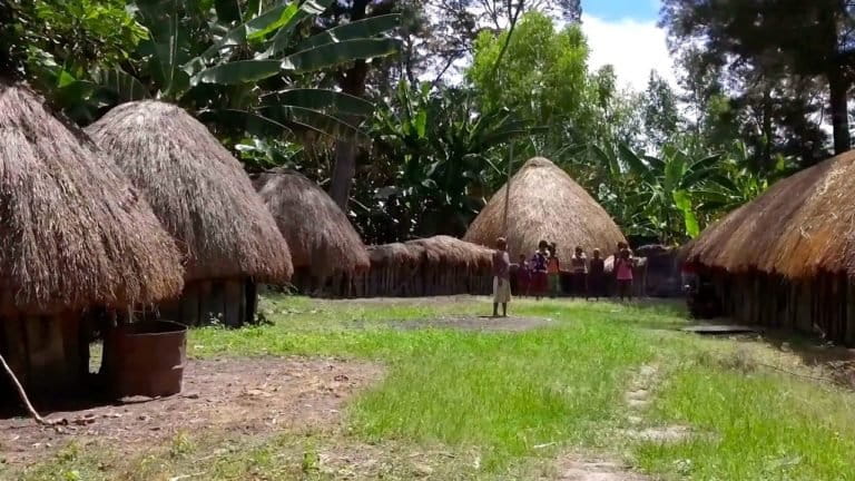
ASOLOKOBAL, Indonesia — Laurensius Lani’s footsteps can be heard at dawn alongside the traditional honay thatched-roof houses of the Baliem Valley, here in the archipelago country’s eastermost Papua province.
This is a region of biodiversity and riches. Asolokobal sits on the southern end of Indonesia’s sole snow-covered mountain range. Tasmanian tigers (Thylacinus cynocephalus), long thought to be extinct in the wild, were said to be spotted here not long ago. Yet, 125 miles north along the Jayawijaya range is the world’s largest copper and gold mine, operated by U.S. company Freeport-McMoRan.
Since 1996, Lani has worked with the Foundation for the Customary Development of Walesi (YBAW), a local NGO, to map indigenous peoples’ customary lands. He sees such mapping as the first step towards empowering these communities to use their land sustainably. The lack of clearly delineated boundaries is a big problem in Indonesia, one often taken advantage of by large companies trying to acquire community lands for development.
Over the last 20 years, the foundation has mapped 19 of the 27 customary territories here in Jayawijaya district – not easy work given the many peaks in Indonesia’s highest altitude region. Jayawijaya customary lands include Mount Trikora (4,750 meters/15,600 feet above sea level), Mount Mandala (4,700 meters above sea level), Mount Yamin (4,500 meters above sea level) and Lake Habema (3,200 meters above sea level). These magnificent land features sit in Lorenz National Park — the largest national park in Southeast Asia.
The territories the team has mapped range from the enormous (26,000-hectare Inyarek; 22,000-hectare Uelesi; and 18,000-hectare Aluama) to the minute (Tuma, which is wedged alongside the Uelesi region).
“I started advocating for local rights after returning from Jayapura,” Lani explained, referring to the provincial capital. “With technological advances, many locals are choosing to sell their land; our forest and people are beginning to change.” Lani said this trend was not isolated. It is happening in Wamena and other areas of Jayawijaya too.
Jayawijayans traditionally regard the earth and forest as their “mother,” entities that feed, contain and nurture. From this perspective, the sale of the very earth and land seem especially sad to Lani, who is keenly aware that natural resources are finite.
“Mapping is one means to preserve local rights. If we manage our lands, there will be a legacy for our children and grandchildren to inherit. After all, the earth and forest itself does not get longer or wider, or have its own offspring. Man does.”

Government offices in Jayawijaya and Jakarta have supported Lani’s foundation and its mapping initiative, since so much conflict — both interethnic and that pitting communities against companies and the state — is related to disputes over land and forest ownership.
“With territories mapped, people have a clearer idea of boundaries and better sense of areas they are not allowed to enter,” said Yunus Matuan, the head of Jayawijaya’s Forestry Office. “If all the indigenous lands were mapped, we might have zero conflict.”
Once boundaries are delineated, the hope is to gather demographic data such as population size, the age and education levels of the populace, the number of ceremonial locations such as honai and the variety of infrastructure such as health centers. There are also plans to include regional planning details such as zoning for future paddy fields, livestock and agricultural lands, clean water sources, fishery and forestry sources.
Natural and agricultural features are also important to note, according to Cornelis Oagay, from the Center for the Study of Community Empowerment (LSPK), a local mapping and planning institution. “After this process, we will register our maps with the national Ancestral Domain Registration Agency [BRWA],” he said. “We hope this data will enable the government to create and adjust regional regulations in a more informed, collaborative manner.”
At first local communities were suspicious about the idea of mapping their territories. They worried the maps were being made in order to steal their lands. Gradually, though, the communities in different customary areas came to believe in the importance of mapping. They were especially drawn to the idea that mapping could lead to regional management plans on which they would have input.
“Drawing up the customary land maps feels like the building of a strong, sturdy wall for our children and grandchildren, “said Enius Lokobal, an Asolokobal church and community leader. “If you have a fence, a set of rules and legislation, our people will feel protected and secure in our thoughts for future generations. This way, we can develop our ancestral lands in line with our own needs.”
This story was reported by Mongabay’s Indonesia team and was first published on our Indonesian site on Nov. 17, 2016.
Banner image: Local community members discuss review of a map of their area at a church in Asolokobal. Photo by Wahyu Mulyono for Mongabay


