|
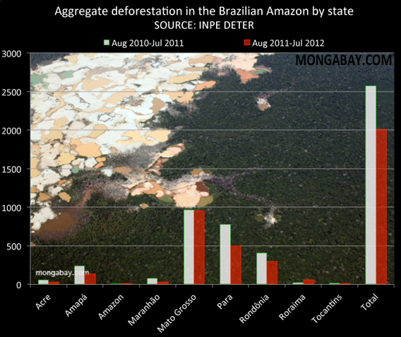
Deforestation in the Brazilian Amazon fell by more than a fifth for the 12-month period ending July 31, 2012, according to preliminary data released by Brazil’s National Institute for Space Research (INPE).
INPE’s Real Time Deforestation Detection System (DETER), picked up 2011 square kilometers of forest clearing between August 1, 2011 and July 31, 2012. In the year-earlier period, deforestation amounted to 2,578 sq km.
DETER is based on relatively coarse satellite imagery, using 25 hectare pixels from NASA’s MODIS sensor. Since the system misses a significant proportion of deforestation, Brazil relies on PRODES (Program to Calculate Deforestation in the Amazon), which can detect areas of deforestation of more than 6.5 hectares, to make the final determination of deforestation on a year-to-year basis, usually releasing estimates each December. INPE cautions that DETER data should not be used to estimate annual rates of deforestation.
Brazil is well ahead of its 2009 target for reducing deforestation in its Amazon region, which accounts for roughly 60 percent of the total Amazon rainforest. The deforestation reduction goal is part of the national climate plan. Still some environmentalists and scientists fear that a pending change to the country’s Forest Code, which limits forest clearing on private lands, could reverse recent progress in cutting deforestation. The revised version of the Forest Code would give farmers and ranchers greater latitude on land-clearing.
The Amazon is Earth’s largest rainforest. 70 percent of South America’s GDP is produced within the rain shadow of the Amazon, which is thought to store more than 85 billion tons of carbon in its vegetation.
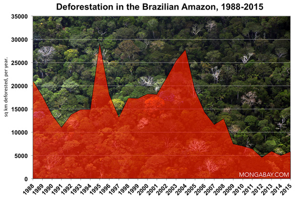
 Historical deforestation in Brazil. Data from PRODES, rather than DETER.
Related articles


