Pittsburgh has more urban sprawl than Los Angeles, new maps show
University of Toronto
April 26, 2006
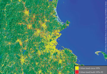
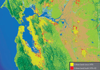
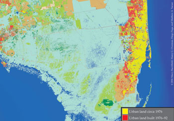
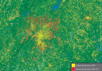
Recent urban development in Los Angeles is less scattered than recent development in Boston. Miami is America’s most compact big city and Pittsburgh its most sprawling. Changing the number or size of municipal governments in a metro area has no impact on whether or not urban development is scattered, but controlling access to groundwater does. These are among the startling findings from a University of Toronto-based team of researchers who used satellite data and aerial photography to create a grid of 8.7 billion data cells tracking the evolution of land use in the continental United States.
Matthew Turner and Diego Puga of the University of Toronto (Puga is currently a visiting professor at Universitat Pompeu Fabra), Marcy Burchfield of the Neptis Foundation, a Toronto-based organization focused on urban and regional research, and Henry Overman of the London School of Economics present their findings in the May issue of The Quarterly Journal of Economics, in a paper entitled Causes of Sprawl: A Portrait from Space. Heavily illustrated with Geographic Information System images, the paper challenges conventional wisdom about urban sprawl and presents a vivid and detailed picture of land consumption in America’s cities.
Though urban sprawl is widely regarded as an important environmental and social problem, according to the authors, much of the debate over sprawl is based on speculation. The data to conduct detailed and systematic measurement of how and where land is converted to urban use has, until now, simply not been available. Despite widespread interest in the topic, “we know next to nothing about the extent to which development is scattered or compact, and how this varies across space,” they write.
The authors merged high-altitude photos from 1976 with satellite images from 1992 (the most recent available) to create a grid of 8.7 billion 30-metre by 30-metre cells that tracks land use changes nationwide. “The data set we’ve constructed is unprecedented in that we have coverage of the whole continental United States with a very high degree of accuracy for two time periods. That’s never been done before,” says Turner.
The new high-resolution data allow the authors to observe the amount of open space in the neighbourhood of every house in every U.S. city. Since development is more scattered when there is more open space around a house, the authors measured urban sprawl by calculating the average amount of open space in the neighborhood of a house in each city.
They found that more recent residential development is not any more scattered than development was in 1976. Forty two per cent of land in the square kilometre surrounding the average residential development in 1976 was open space, compared with 43 per cent in 1992. “While a substantial amount of scattered residential development was built between 1976 and 1992, overall residential development did not become any more biased toward such sprawling areas.” The authors are quick to point out that any one household would have seen much change in the study period, but that “if we zoom out and look at the city from a distance, we see little change, at least in terms of the proportions of sprawling and compact development: the new city is just like an enlarged version of the old city.”
Overall, Boston is less scattered than Atlanta, however recent development in Boston has been less compact than recent development in Atlanta. Miami, San Francisco and Los Angeles were the most compact major cities, while Pittsburgh and Atlanta were the most scattered.
The authors also investigated why some cities are more sprawling than others. They found that a city’s climate, topography and access to groundwater account for 25 per cent of the nationwide variation. When the climate is temperate, people spread out to have more space to enjoy the weather. Hilly places see more scattered development as people avoid the costs of building on hillsides — but mountains act as a barrier and lead to more compact development. Places with easy access to groundwater see more scattered development, since people can supply remote houses with water by drilling inexpensive wells rather than paying for water lines.
“The presence of aquifers is particularly important,” says Turner, “and that seems to me to have policy implications. It looks as if controlling access to groundwater is an important way to control whether development spreads or not.”
Roads, on the other hand, have no impact on the extent to which development is scattered, despite commonly held beliefs to the contrary. “We looked at a lot of measures of road density — miles of road per area, average distance to a road, distance to an interstate exit — and we could find no relation between those measures and the scatteredness of development,” Turner says.
The number of municipalities in a metropolitan area also does not affect development patterns. “You hear about fragmentation of jurisdictions being an important determinant of development patterns and we could find no evidence for that,” says Turner. However, the team also found that development near cities is less scattered if it occurs in a municipality than if it occurs in an unincorporated area of a county. This suggests that people may be moving out to just beyond municipal boundaries in order to avoid more stringent municipal regulations.
One of the common complaints about urban sprawl is that as development spreads, municipal services such as roads, sewers, police and fire protection are more expensive. The authors suggest that this concern is well founded. Development in municipalities that receive larger subsidies from higher levels of government is, on average, more scattered. Says Puga, “This suggests that as local taxpayers are held accountable for infrastructure costs, they respond by insisting on patterns of development that require less infrastructure spending.”
“People have been eager to rush to policy prescriptions without a very good understanding of the underlying phenomena,” says Turner. “We wanted to try to put the policy discussion on sounder footing.”
This is a news release from University of Toronto


