• Features
  • Videos
  • Podcasts
  • Specials
  • Articles
  • Shorts
Donate
  • English
  • Español (Spanish)
  • Français (French)
  • Bahasa Indonesia (Indonesian)
  • Brasil (Portuguese)
  • India (English)
  • हिंदी (Hindi)
  • বাংলা (Bengali)
  • Swahili
  • Videos
  • Podcasts
  • Articles
  • Short News
  • Feature Stories
  • The Latest
  • Explore All
  • About
  • Team
  • Contact
  • Donate
  • Subscribe page
  • Submissions
  • Privacy Policy
  • Terms of Use
  • Advertising
  • Wild Madagascar
  • For Kids
  • Mongabay.org
  • Reforestation App
  • Planetary Health Check
  • Conservation Effectiveness
  • Mongabay Data Studio

Latest

Panorama of Mount Donna Buang in Australia

Australia declares mainland alpine ash forests endangered

Megan Strauss 16 Apr 2026

A chimpanzee’s rhythmic drumming with floorboards hints at origins of instruments

Liz Kimbrough 16 Apr 2026

10 forces that could reshape the future of the world’s forests

Rhett Ayers Butler 16 Apr 2026

Strait of Hormuz crisis should catalyze African biofertilizer production (commentary)

Susan Chomba 16 Apr 2026

San Francisco Bay emerges as high-risk area for migrating gray whales

David Brown 15 Apr 2026

See an orangutan, take a photo, earn some money: A viable conservation model?

Linnea Hoover 15 Apr 2026
All news

Top stories

A yellow-fronted canary from South Africa. The songbird tops the list of wild birds exported from Africa to Asia.

Nearly a million birds shipped from Africa to Asia in 15 years; canaries top the list

In Brazil, unfinished water project leaves Indigenous villages without safe water

Felipe Medeiros, Adriana Amâncio 14 Apr 2026
Schaller with a peccary. Courtesy of the George B. Schaller Archive.

George Schaller: The field biologist who helped redefine conservation

Rhett Ayers Butler 14 Apr 2026
Emmanuel de Merode at an airstrip near Salonga National Park in DRC in March 2026. Photo by Rhett Ayers Butler

Can nature outcompete war in Eastern Congo?

Rhett Ayers Butler, David Akana 13 Apr 2026
Rangers at Gashaka Gumti National Park, Nigeria

Defying conflict to track the world’s rarest chimpanzees

Leo Plunkett, Tom Richards, Sandy Watt 13 Apr 2026

Subscribe

Stay informed with news and inspiration from nature’s frontline.
Newsletter

We’re a nonprofit

Help us tell impactful stories of biodiversity loss, climate change, and more
Donate

News and Inspiration from Nature's Frontline.

Rangers at Gashaka Gumti National Park, Nigeria
Videos
Articles
A coyote in Chicago. Image courtesy of Cook County Coyote Project.
Podcasts

Special issues connect the dots between stories

Primate Planet

Rangers at Gashaka Gumti National Park, Nigeria

Defying conflict to track the world’s rarest chimpanzees

Leo Plunkett, Tom Richards, Sandy Watt 13 Apr 2026
Izzy Sasada and orangutan

Orangutans rescued undergo re-training to return to the wild

Izzy Sasada, Sam Lee 17 Dec 2025
In Java, communities help reconnect fragmented forests to help save the endangered Javan gibbon

Natural bridges to reconnect the last Javan gibbons

Nanang Sujana, Sandy Watt 18 Jun 2025
What singing lemurs can tell us about the origin of music

What singing lemurs can tell us about the origin of music

Sam Lee 8 Jan 2025

Across the tropics, a growing movement is working to secure a future for primates in the face of disease, deforestation and wildlife trade. Reporting from across the planet, this video series highlights how scientists, conservationists and local communities are rebuilding populations and reconnecting fragmented forests. Along the way, it reveals the innovation, collaboration and resilience […]

Primate Planet series

More specials

Guasimas Bay has been contaminated by agrochemicals and waste that is released from shrimp farms not far from the coast.
5 stories

Who controls Mexico’s Yaqui River?

12 stories

Beyond the screen: DCEFF

A dairy cow in a farm in the Netherlands.
5 stories

The Dutch Nitrogen Crisis

Free and open access to credible information

Learn more

Listen to Nature with thought-provoking podcasts

A coyote in Chicago. Image courtesy of Cook County Coyote Project.

Coexisting with America’s growing urban coyote population is easier than you think

Mike DiGirolamo 14 Apr 2026

Watch unique videos that cut through the noise

Rangers at Gashaka Gumti National Park, Nigeria

Defying conflict to track the world’s rarest chimpanzees

Collage of a cloned jaguar

Lab-made jaguar: Is cloning a solution to extinction?

Julia Lima, Gustavo Fonseca, Letícia Klein 30 Mar 2026
Collage of a red-bellied toad and a bridge broken by flood

In search of the tiny toad that stopped a dam

Thamys Trindade, Felipe Rosa, Julia Lima 14 Mar 2026
Collage featuring cockfighting and a largetooth sawfish

Why is cockfighting a risk to Peru’s rarest fish?

Romi Castagnino 25 Feb 2026
Collage featuring a white-rumped shama (Copsychus malabaricus) and a poacher

The most desirable songbird in Indonesia is disappearing from the wild

Rizky Maulana Yanuar, Sandy Watt 18 Feb 2026

We’re a nonprofit

Help us tell impactful stories of biodiversity loss, climate change, and more
Donate

In-depth feature stories reveal context and insight

Kushki (male) is one of the last surviving Asiatic cheetahs from northeastern Iran’s Miandasht Wildlife Refuge.
Feature story

War on Iran disrupts efforts to save the Asiatic cheetah, world’s rarest big cat

Kayleigh Long 9 Apr 2026
Feature story

As EU-Mercosur agreement goes into effect, environmentalists raise red flags

Ramana Rech 8 Apr 2026
Feature story

Mennonites from Belize spark deforestation fears with new settlement plans in Suriname

Maxwell Radwin 8 Apr 2026
Shark meat in Brazil. Image by Philip Jacobson/Mongabay.
Feature story

Latin America’s largest hospital complex cancels plan to buy shark meat

Philip Jacobson, Lucas Berti, Karla Mendes 7 Apr 2026

Quickly stay updated with our news shorts

Australia declares mainland alpine ash forests endangered

Megan Strauss 16 Apr 2026

The Australian government recently listed the iconic alpine ash forests of mainland Australia as an endangered ecological community, citing ongoing threats from increasingly severe, frequent bushfires and climate change. While conservationists supported this decision, members of the timber and forestry industry questioned the move.

Alpine ash forests occur on high country slopes in the states of Victoria and New South Wales and the Australian Capital Territory, at elevations of 900-1,500 meters (about 3,000-5,000 feet). These culturally significant forests sit within the traditional lands of many First Nations peoples.

Alpine ash (Eucalyptus delegatensis), a tall eucalypt with menthol-scented leaves, dominates these forests. Alpine ash forests also support a rich community of other plants and animals, including lyrebirds and spotted-tailed quolls. The hollows of old-growth trees are important habitat for the critically endangered Leadbeater’s possum (Gymnobelideus leadbeateri).

A spokesperson for the Department of Climate Change, Energy, the Environment and Water (DCCEEW) told Mongabay by email that the listing followed a “thorough assessment by the national Threatened Species Scientific Committee,” which “included a public consultation process and substantial input from many forest experts.”

The spokesperson said proponents of activities that may significantly harm alpine ash forests will now need to fully avoid impacts on the forests or demonstrate “a net gain,” meaning environmental benefits outweigh the damage. This will lead to stricter assessments.

The Victorian National Parks Association called the listing “an important step.” Forest and fire scientists writing in The Conversation said alpine ash is “facing an existential threat” and the listing “is a clear warning to Australians.”

However, Forestry Australia, a nonprofit association of forest managers, said: “Listing such an extensive and predominantly intact ecosystem, most of it located on public land already managed for conservation, represents an unprecedented step in Australia.”

The Australian Forest Products Association said the listing went against scientific evidence and highlighted that the geographic extent of alpine ash forest has decreased by only 5% since 1750.

However, the DCCEEW spokesperson told Mongabay that the listing of alpine ash forest as endangered was not due to a loss of geographic extent, but “because of a severe and ongoing decline in condition and function, and difficulty in recovering from bush fires.” They added that more than 80,000 hectares (nearly 200,000 acres) of forest were lost during the massive 2019-2020 summer bushfires and that multiple fires in the same area pose a clear threat.

Alpine ash trees only reach reproductive maturity and produce viable seed at 20 years of age. “More than half of the ecosystem is now structurally immature,” the spokesperson said. Young forests are particularly vulnerable; they lack seed and can’t naturally regenerate if exposed to repeated fires.

While a recovery plan for alpine ash forests was not deemed necessary, the government’s Conservation Advice document provides guidance for actions to manage threats, including protecting old-growth stands and regrowth from future fires.

Banner image: Mt. Donna Buang in Victoria. Image by Bob Tan via Wikimedia Commons (CC BY 4.0).

Panorama of Mount Donna Buang in Australia

San Francisco Bay emerges as high-risk area for migrating gray whales

David Brown 15 Apr 2026

Gray whales have one of the longest known migrations of any mammal — from the Arctic near Alaska, to the lagoons of Baja Mexico, where they mate and give birth. This annual migration, longer than 19,000 kilometers (12,000 miles), has been altered by climate change, with profound consequences for the 15-meter (50-foot) mammals. Since 2016, the population has declined by more than 50%.

Historically gray whales (Eschrichtius robustus) were not known to enter San Francisco Bay on their migration. But using photo surveys, researchers recorded 114 individual whales in the area between 2018 and 2025.

Researchers found 70 gray whale carcasses in the area and matched 21 of them to the individuals previously identified, meaning at least 18% of the identified whales were confirmed dead in the area. However, the true mortality could be higher, as some dead whales could have gone undetected.

“The minimum mortality rate of 18% observed in San Francisco seems to be unique in terms of the intensity of mortality, though gray whales face threats and die across their entire migratory route,” Josephine Slaathaug, first author of a study documenting the findings and a gray whale researcher at Sonoma State University in the U.S., told Mongabay by email.

Ship strikes are a major factor: 30 of the dead whales were hit by boats, illustrating the dangers of expanding their range into an urban area like San Francisco Bay.

Other whales apparently died of malnutrition, potentially explaining why they entered the bay to begin with. Climate change is disrupting the Arctic food web, Slaathaug said. “As the Arctic warms, ice melt impacts the invertebrate species that carry high nutritional value for these whales.”

Gray whales are coastal bottom feeders, using their baleen plates to filter tiny invertebrates from the seafloor, or benthic layer. Earlier-than-usual ice melt means that phytoplankton bloom earlier and are eaten before they can fall to the seafloor to feed benthic invertebrates, which are gray whale food. Collapsing benthic invertebrate populations can lead to malnourished whales that need to find food on their migration route.

San Francisco Bay may be an emergency pit stop for such whales. “Research is ongoing to determine what these whales may be feeding on, or attempting to feed on, in San Francisco Bay,” Slaathaug said.

Researchers are working to prevent human-caused gray whale deaths, including by boat strike. “There are education initiatives ongoing with the maritime community in San Francisco Bay, led by the Marine Mammal Center, but stricter conservation strategies such as mandatory slow speed zones may be necessary if the pattern of mortality continues,” Slaathaug said.

Rachel Rhodes, a marine biologist not affiliated with the study, told The New York Times that

San Francisco Bay is “such a uniquely complex and busy waterway. Then you add whales into the mix, and there’s just not a lot of room to coexist.”

Banner image: A gray whale breaching. Image by Merrill Gosho/NOA via Wikimedia Commons (Public domain).

Brazil: Satellites expose rampant gold mining expansion on Indigenous Kayapó land

Shanna Hanbury 15 Apr 2026

The Kayapó Indigenous Territory has emerged as a major hotspot for illegal gold mining in the Brazilian Amazon’s Xingu River Basin, a major Amazon tributary. That’s according to a new report from the watchdog Monitoring of the Andes Amazon Program (MAAP).

At least 7,940 hectares (19,620 acres) of forest on Kayapó land were cut down for mining since 2018, according to Amazon Mining Watch. Around 140 hectares (346 acres) were felled in 2025.

The Xingu Basin, a 51-million-hectare river basin (126 million acres), roughly the size of Spain, cuts through Brazil’s Pará and Mato Grosso states and is home to some of the highest levels of deforestation from illegal gold mining in Brazil.  

In May 2025, the Brazilian government carried out operations to remove illegal miners, destroying 25 large excavators, almost 1,000 tents and more than 400 engines. They seized 63 grams (2.2 ounces) of gold and almost 500 kilograms (1,100 pounds) of refined cocaine and cocaine base paste. A month later, in June 2025, just 2 hectares (5 acres) of land were illegally deforested.

But by October 2025, mining activities began to encroach on the forest again, and an additional 15 hectares (37 acres) were deforested, MAAP’s satellite monitoring showed.

Mining in the east of the Kayapó Indigenous Territory. Image courtesy of MAAP. Data from Planet/NICFI.
Mining in the northeast of the Kayapó Indigenous Territory. Image courtesy of MAAP. Data from Planet/NICFI.

Roughly 16,000 hectares (39,540 acres) of forest were destroyed between 2018 and 2024, according to Amazon Mining Watch. An additional 400 hectares (990 acres) of mining-related deforestation was recorded between January and September of 2025.

“Illegal mining in the Xingu basin is not an isolated activity,” the MAAP report writes. “It has spread to both Indigenous territories and protected areas, indicating the existence of a support network that provides the operational capacity and infrastructure necessary for the activity. This expansion brings with it a series of serious risks to the region and its communities.”

Mercury used in mining contaminates the rivers that communities depend on for drinking, bathing and fishing. Stagnant pools of mining waste also become biohazards: outbreaks of mosquito-borne diseases such as malaria and yellow fever are frequent.

Mining and deforestation in the Xingu Basin corridor impacts five protected areas (Altamira National Forest, Iriri State Forest, Riozinho do Anfrísio Extractive Reserve, Nascentes da Serra do Cachimbo Biological Reserve and Rio Iriri Extractive Reserve) and five Indigenous lands (Kayapó, Baú, Kuruaya, Trincheira Bacajá and Apyterewa). 

In the Baú Indigenous Territory, 10 hectares (25 acres) were cut down for mining in 2025. In the Kuruaya territory farther north, satellites detected another 4 hectares (10 acres) of deforestation.

Mining in Kuruaya Indigenous Territory. Map courtesy of MAAP. Data by Planet/NICFI.
Mining in Baú Indigenous Territory. Map courtesy of MAAP. Data by Planet/NICFI.

Banner image: Pista Velha mining site in the Baú Indigenous Territory captured during an overflight on July 19, 2025. Image courtesy of the Xingu+ Network.

Pista Velha mining site in the Baú Indigenous Territory captured during an overflight on July 19, 2025. Image courtesy of the Xingu+ Network.

Invasive ferrets removed from an island in a world-first

Shreya Dasgupta 15 Apr 2026

Rathlin Island off the north of Northern Ireland is now free from feral ferrets that were harming its native seabirds. Conservationists say this is the first time these nonnative animals, which were domesticated from polecats some 2,000 years ago, have been completely eradicated from any island.

Ferrets (Mustela furo) were introduced to Rathlin in the 1980s to control another invasive species, rabbits, which were considered agricultural pests. However, instead of targeting rabbits, the ferrets multiplied and feasted on seabirds, ground birds, and their eggs and chicks, said Erin McKeown, program manager of the Life Raft ferret-eradication project led by the Royal Society for the Protection of Birds Northern Ireland (RSPB NI).

Rathlin Island is home to more than 250,000 seabirds like puffins, razorbills, guillemots and Manx shearwaters. 

“On Rathlin, there has been over 70% of decline in puffin population,” McKeown told Mongabay by phone. “There are loads of different reasons for this decline, but one of the big ones is overpredation by ferrets. For example, a feral ferret got into our puffin colony in 2017 and in a two-day period had killed over 26 mature puffin birds. These are a species that will lay one egg a year.”

In 2021, a five-year, 4.5-million-pound ($6.1 million) project, involving RSPB NI, government agencies, other charities and the local community, was launched to eradicate ferrets on Rathlin.

There were an estimated 93 ferrets on the island at the time; all have now been removed by trappers, McKeown said.

The project team also relied on a network of 110 cameras and thermal drones to search for ferrets. Woody, a detection dog, played a key role, sniffing out ferrets from their droppings.

After no signs of ferrets in two years, the island has been declared ferret-free. Still, the cameras and Woody continue to monitor Rathlin for the invasive mammals. “He is now still used to help us declare absence since he’s not detecting them on site,” McKeown said. 

With ferrets removed, early signs suggest the seabirds are recovering. Puffin populations in 2025 were the highest in the last five years, and many shearwaters bred on Rathlin after 40 years, McKeown said. Last year, six male corncrakes (Crex crex), considered endangered in the U.K, were also recorded calling. Corncrakes are ground-nesting birds that have nearly disappeared from the region.

A ferret-free island will likely benefit the community as well, McKeown said. “We’ve heard anecdotally from the community that they can have livestock and chickens now that they couldn’t have had previously because they would’ve just been preyed on so easily by the ferrets.”

“Achieving a successful ferret eradication has never been done before anywhere in the world,” Elizabeth Bell, a technical expert from Aotearoa New Zealand-based Wildlife Management International, said in a statement. “The lessons learned here will benefit island restoration projects globally for decades to come.”

Ferrets are also considered invasive in New Zealand, where they’ve driven declines of several ground-nesting birds.

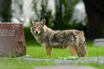
Banner image of a ferret by Alfredo Gutiérrez via Wikimedia Commons (CC BY-SA 4.0).

a ferret by Alfredo Gutiérrez via Wikimedia Commons (CC BY-SA 4.0).

Exploring giraffe-human conflict in Kenya

David Brown 14 Apr 2026

Reticulated giraffes are an endangered species across their primary range in Kenya, most commonly threatened by habitat loss and illegal hunting. Conflicts with people are also rising as giraffes sometimes eat crops like mangos and compete with local people for water. A group of researchers investigated emerging human-giraffe conflict (HGC) in northeastern Kenya found that, despite tension, there is widespread local support for giraffes by local people, and opportunities to reduce conflict.

Fewer than 20,000 reticulated giraffes (Giraffa reticulata) are estimated to remain in the wild, roughly a 56% population decline over the last 30 years, according to the IUCN, the global wildlife conservation authority.

The research team worked in the Bour-Algy Giraffe Sanctuary, which was created along the Tana River in northeastern Kenya to protect the local population of reticulated giraffes. The sanctuary was created by volunteers from Bour-Algy village in 1995, but before this study there was little formal understanding of how local people felt about the giraffes and what impact giraffes had on their lives.

The researchers conducted 400 interviews with households around the sanctuary. Their goal was to learn about local attitudes toward giraffes — whether people perceived them as a risk, what caused conflicts with giraffes and determine local strategies for coexistence.

The team found that there was a relatively high tolerance for giraffes in the community. “Most respondents viewed giraffes as low-risk and over half reported no damage to land or property,” Abdullahi Ali, first author of the study, told Mongabay in an email. “Importantly, the concerns raised were largely indirect, particularly competition for water, habitat encroachment, and broader livelihood pressures, rather than giraffes themselves.”

Ali said negative perceptions of giraffes were largely limited to farmers who occasionally lose crops to the animals. “In contrast,” Ali noted “individuals engaged in other socio-economic activities such as pastoralism, trade, or government employment tend to have no issues with giraffes.”

He added that the findings highlight the need for community-based coexistence strategies. “Key priorities include improving awareness, reducing competition over critical resources such as water and supporting locally relevant livelihood initiatives.”

Ali is also part of the Somali Giraffe Project, a conservation group in the same area. Ali said the group is working to address the main sources of human-giraffe conflict.

“The Somali Giraffe Project is addressing water scarcity by providing alternative water sources for giraffes and other wildlife, helping to reduce pressure on shared resources like the Tana River,” Ali said. “The project has established the region’s first wildlife education center, where schoolchildren, farmers, youth and elders are educated about giraffe conservation.”

Monica Bond, a giraffe biologist in neighboring Tanzania, who wasn’t involved with the study, said the findings provide “a useful model for how to quantify conflicts and risks, and to understand what people require to live safely and peacefully with giraffes.”

Banner image: A reticulated giraffe in a national park in Kenya. Image by Stolz Gary M, U.S. Fish and Wildlife Service via Wikimedia Commons (Public domain).

Ghana declares its first marine protected area

Victoria Schneider 14 Apr 2026

Ghana has declared its first marine protected area after more than 15 years of efforts to bolster marine conservation and safeguard its depleting fish stocks.

Vice President Naana Jane Opoku-Agyemang announced the creation of the MPA on April 14. It marks a “historic moment,” according to Ghana’s fisheries commission, Benjamin Campion.

The designated area covers 703 square kilometers (271 square miles) in the greater Cape Three Points area, at the southernmost tip of the country. A key spawning and nursery ground for small pelagic fisheries, targeting fish near the water’s surface, the area has been identified as having the potential to restore critical fish populations.

The protected area will consist of a core zone where no fishing will be allowed and multiple-use zones where fishing and other activities will be still be permitted, but strictly regulated.

“The MPA forms part of a broader national strategy to rebuild Ghana’s fisheries sector, complementing existing interventions,” Campion told Mongabay via email.

Ghana’s small pelagic fishery is at risk of collapse due to years of overfishing by a growing artisanal sector, the use of destructive gear and fishing methods by industrial trawlers, and the effects of climate change. These pressures increasingly threaten the country’s food security, as a majority of the population’s animal protein intake comes from small pelagics.

In response, Ghana has implemented multiple conservation measures to ease pressure on populations of sardinella (Sardinella spp.), anchovy (Engraulis encrasicolus) and mackerel (Scomber japonicus). These include seasonal fisheries closures, a three-year moratorium imposed in 2023 on new canoes entering the artisanal fishery, a trawl gear directive, and the reclassification and registration of all fishing vessels.

The MPA aims to support the “long-term protection of critical habitats, supporting the sustained recovery and resilience of marine fisheries resources over time,” Campion said.

The creation of the MPA suffered a setback in 2025 when the U.S. government slashed funding for aid agency USAID. USAID was a key supporter of increased regulation of Ghana’s fisheries sector, including the establishment of MPAs.

Stephen Kankam, from Ghanaian NGO Hen Mpoano, which has been involved in the planning and design of the MPA, told Mongabay by email that the declaration is significant as a practical step toward rebuilding the country’s fisheries, “not just in policy, but on the ground.”

He added that communities have been at the heart of the designation process, contributing to the identification of fishing grounds and breeding areas. “That local knowledge has been built into the design of the MPA,” Kankam said, adding that the site will be managed according to a co-management model.

Twenty-one participating communities have representatives in community management groups, which serve as points of contact for higher-ranked decision-making committees.

According to Kankam, the next steps will be to finalize the MPA’s zoning system — clarifying what activities are allowed where — and to ensure that monitoring, enforcement and compliance mechanisms are effective.

Banner image: Cape Three Points village, Ghana. Image by Tini Maier via Flickr. CC BY 2.0.


Share Short Read Full Article

Share this short

If you liked this story, share it with other people.

Facebook Linkedin Threads Whatsapp Reddit Email

Subscribe

Stay informed with news and inspiration from nature’s frontline.
Newsletter

News formats

  • Videos
  • Podcasts
  • Articles
  • Specials
  • Shorts
  • Features
  • The Latest

About

  • About
  • Contact
  • Donate
  • Impacts
  • Newsletters
  • Submissions
  • Terms of Use

External links

  • Wild Madagascar
  • For Kids
  • Mongabay.org
  • Reforestation App
  • Planetary Health Check
  • Conservation Effectiveness
  • Mongabay Data Studio

Social media

  • LinkedIn
  • Instagram
  • Youtube
  • X
  • Facebook
  • Tiktok
  • Reddit
  • BlueSky
  • Mastodon
  • Android App
  • Apple News
  • RSS / XML

© 2026 Copyright Conservation news. Mongabay is a U.S.-based non-profit conservation and environmental science news platform. Our EIN or tax ID is 45-3714703.

you're currently offline