
- Official data show Indonesia lost an area of forest two-thirds the size of London in 2021-2022, marking a third straight annual decline.
- The government attributes the continued drop to various forest protection policies, such as permanent ban on new permits to clear primary forests and peatlands as well as forest fire mitigation.
- However, data from the University of Maryland show Indonesia’s primary tree cover loss actually increased by 13% in 2022 compared to 2021 data — the first increase since 2017.
- The disparity in data comes from differences in methodology and definitions of deforestation and forests adopted by UMD and the Indonesian government.
JAKARTA — Indonesian officials say the country’s deforestation rate continued to decline for the third year running, hitting a historical low in 2021-2022. But claims of an improving trend are dogged by a long-running controversy over how Indonesia defines forest loss.
Data from the Ministry of Environment and Forestry show that the country, home to the third-largest expanse of tropical forest in the world, lost 104,000 hectares (257,000 acres) of forests — an area two-thirds the size of London — from July 1, 2021, to June 30, 2022.
This marks an 8.4% decline from the 113,500 hectares (280,400 acres) of deforestation in 2020-2021. It also means a third straight annual decline in Indonesia’s deforestation rate, and the lowest figure since the forestry ministry began tracking annual deforestation rates in 1990.
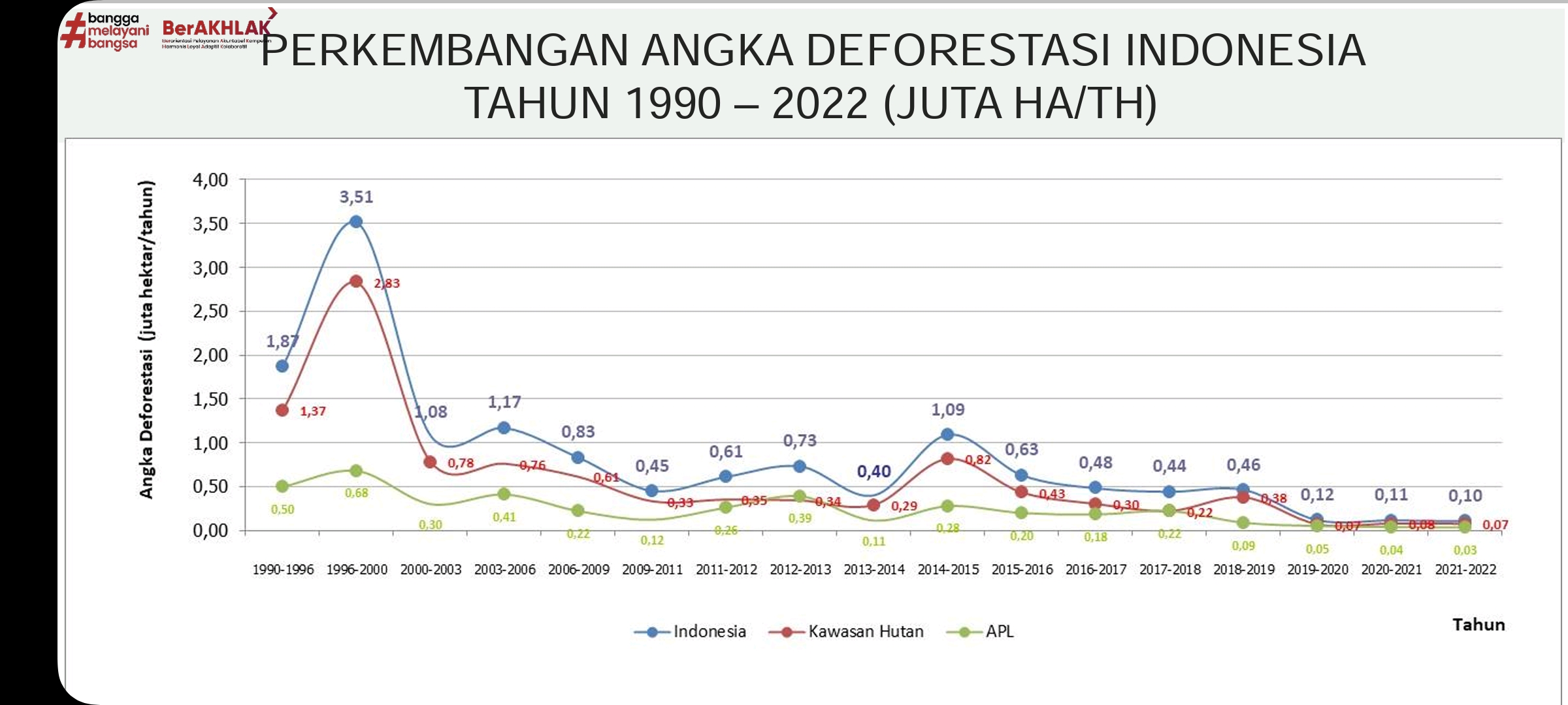
The ministry attributed the trend to the culmination of a number of forest protection policies. These include a permanent ban on issuing new permits to clear natural old-growth, or “primary,” forests and peatlands; efforts to prevent and tackle forest fires; a social forestry program that puts communities in charge of managing forest resources; land rehabilitation programs; and increased enforcement against environmental violations.
“Our monitoring so far shows our deforestation to keep declining. This has to do with corrective actions from the ministry,” said Ruandha Agung Sugardiman, the forestry ministry’s director-general of planning.

Declining forest loss
The ministry’s latest figures show Indonesia has 96 million hectares (237 million acres) of natural forest remaining, representing 51.2% of the country’s land mass. That’s more than double the size of California, and behind only Brazil and the Democratic Republic of Congo in terms of tropical forest area.

The trend of slowing forest loss reflected in the official data chimes with data from other sources. The latest tree cover loss data from the University of Maryland (UMD), available on the Global Forest Watch (GFW) platform managed by the World Resources Institute (WRI), shows Indonesia reduced primary forest loss by 64% in the 2020-2022 period from the average during 2015-17.
This means Indonesia has reduced its primary forest loss more than any other country in recent years. However, the UMD data also show that Indonesia’s primary forest loss increased slightly to 230,000 hectares (568,000 acres) in 2022 from 202,900 hectares (501,400 acres) in 2021. This is the first increase since 2017.

The average decline in primary forest loss is in line with declining deforestation for palm oil in recent years.
Indonesia is the world’s biggest palm oil producer and exporter. The expansion of oil palm plantations has been a major driver of deforestation in Indonesia for the past 20 years, accounting for one third, or 3 million hectares (7.41 million acres), of the country’s loss of old-growth forest.
At its peak in 2012, palm oil-driven deforestation amounted to 310,000 hectares (766,000 acres).
But deforestation for palm oil had fallen by 82% over the past decade to 45,285 hectares (111,902 acres) annually from 2018-2020.

EU deforestation regulation
Despite last year’s slight increase in primary forest loss, the UMD data is still a proof that Indonesia is heading in the right direction, said Musdhalifah Machmud, the deputy for agriculture to Indonesia’s chief economics minister.
“The data from WRI confirms Indonesia is a model for reducing deforestation,” she said in a statement. “This is a clear, unambiguous verification that the Government of Indonesia has taken the right steps to protect forests and reduce deforestation. Indonesia has done this without sacrificing sustainable development and economic opportunity.”
Therefore, she argued, Indonesia should not be labelled as a high-risk country by the European Union, which seeks to combat global deforestation by banning the trade of commodities from deforested areas and illegal sources in the European market.
The EU recently adopted a landmark law that serves as a legal basis for the ban.
The law, officially called the European Deforestation Regulation, targets cattle, cocoa, coffee, palm oil, rubber, soy and wood as well as commodities that have been fed by or made using those products, such as leather, chocolate, printed paper and furniture.
The legislation will classify exporting countries based on their deforestation risk. Low-risk countries will have a simpler due diligence procedure while more high-risk countries will have to go through more rigorous checks. The checks will make use of geolocation coordinates, satellite monitoring tools and DNA analysis that can trace product origins.
Critics of the law argue that its classification system could make it difficult for palm oil producers in Indonesia to export their goods to the EU, especially if the country ends up labelled as high risk.
Musdhalifah said the EU should acknowledge Indonesia’s success in reducing its deforestation rate and thus not label the nation as a high-risk country.
“It is unfortunate that the European Union has yet to acknowledge these successes,” she said. “Instead, they seek to shackle Indonesia’s future with the Deforestation Regulation and are even considering labelling Indonesia ‘High Risk’. This would be counterproductive and undermine the EU’s own efforts to expand its relationship with their largest trading partner in ASEAN.”

Differing definitions of deforestation
UMD’s tree cover loss data sometimes show higher figures than the Indonesian government’s official data, even if the trends are similar.
The disparity comes from differences in methodology as well as definitions of forest and deforestation.
The definition of primary forest adopted by UMD and GFW is different than that used by the Indonesian government. GFW includes both intact and non-intact primary forests because the latter, it says, still play an important role in storing carbon and providing essential ecosystem services, even if they are somewhat fragmented.
The Indonesian government, meanwhile, only refers to intact natural forests when identifying primary forests. The government categorizes non-intact forests — those that have been degraded by logging or other human activities — as secondary forests.
That means GFW’s primary forest loss figures for Indonesia are always going to be higher than the official Indonesian version. The latter for the 2021-2022 period was 11,287 hectares (27,891 acres) of primary forest loss.
Much of the primary forest loss in Indonesia according to the GFW analysis is within areas that Indonesia classifies as secondary forest and other land cover (such as mixed dry land agriculture, estate crops, plantation forests, shrubs and others).
There are also differences in the way UMD measures tree cover loss with how the Indonesian government defines deforestation. UMD defines tree cover loss as the complete removal of tree cover canopy across an area of 30 by 30 meters (100 by 100 feet).
In contrast, the Indonesian government defines deforestation as loss occurring within seven classes of forest as derived from the forestry ministry’s land cover map. The map is produced using visual interpretation of Landsat satellite images at a much coarser resolution, 250 by 250 m (820 by 820 ft). This means some deforestation picked up by the GFW analysis won’t be accounted for in the Indonesian figure.
Lastly, the Indonesian government considers reforestation in its net deforestation calculations. Controversially, it counts as reforestation not just the planting of trees to try to restore degraded forests back into natural forests, but also the planting of pulpwood trees — typically acacia and eucalyptus, which are grown and cut in seven-year cycles, typically by large corporations, to make paper products such as tissues and toothpicks.
The inclusion of these industrial plantations in the government’s reforestation equation is because it defines deforestation as the “permanent alteration from forested area into a non-forested area as a result of human activities,” per a 2009 decree from the forestry ministry. Industrial plantations, because of their cycles of planting and harvesting, are seen as not causing “permanent alteration” to the forest cover.
In contrast, UMD’s tree cover loss data doesn’t include any tree cover gain.

Actual vs. net deforestation
What all this means is that Indonesia’s actual forest loss could increase in a given year, but this increase could be offset by tree cover “gain” from pulpwood plantations, thus allowing the government to claim a net declining deforestation rate.
This was the case in the 2020-2021 period, when the forestry ministry recorded 113,500 hectares (280,500 acres) of deforestation. To reach that figure, the ministry took the actual amount of forest lost, 139,100 hectares (343,700 acres, and subtracted 25,600 hectares (63,300 acres) of reforestation. Nearly 90% of that “reforestation” was the planting of pulpwood trees by industrial plantation companies.
The actual deforestation of 139,100 hectares was itself a 16.8% increase from the actual deforestation figure in 2019-2020. But the 2020-2021 reforestation figure was a massive 600% increase from 3,600 hectares (8,900 acres) in 2019-2020.
As a result, the government was able to claim a 1.7% net decrease in the deforestation rate in 2020-2021.

Better data interpretation
In light of the different interpretations of the data, WRI and the forestry ministry are working together on a joint analysis, as part of an agreement signed in February.
It calls for both parties to collaborate in supporting Indonesia’s target of turning its forests into a net carbon sink by 2030.
In the analysis, UMD’s primary forest loss data is overlaid with the forestry ministry’s land cover map. It shows that 67% of the primary forest loss detected by UMD occurs within Indonesia’s official forest cover classes.
The remaining 33% is in mixed dry land agriculture, shrubs, swamp shrubs and other land cover types.
“The upcoming joint analysis will improve our understanding of these issues,” WRI said.
Belinda Arunarwati Margono, the ministry’s director of forest resource monitoring, said that while the UMD tree cover loss data can be used to complement the ministry’s data, the official data should be used as the main reference point. She said this is because the official numbers are supported by ground checks and interpreted by experts who know the local geographical conditions.
Ruandha, the ministry’s director-general of planning, said GFW’s methodology is more appropriate for a global context and shouldn’t apply to specific countries.
“It can’t be implemented just like that in various countries. It depends on the condition in each country,” he said. “So if we use the global methodology, of course the result will differ from our method.”
Banner image: Trucks loaded with freshly cut logs transported for further processing, Gunung Lumut, East Kalimantan, Indonesia. Image by Jan van der Ploeg/CIFOR via Flickr (CC BY-NC-ND 2.0).
FEEDBACK: Use this form to send a message to the author of this post. If you want to post a public comment, you can do that at the bottom of the page.