- A new study finds that less than 16% of Indonesia’s peatlands in need of conservation measures are currently protected.
- The remainder, covering a combined area nearly twice the size of Belgium, are located outside of protected areas.
- This indicates that current conservation and restoration efforts aren’t sufficient and need to be increased, researchers say.
- They offer their study as a tool for policymakers to precisely identify peat areas where different types of interventions should be prioritized.
JAKARTA — Most peatlands in Indonesia that need protection are currently not protected, a new study has found.
It identifies 5.65 million hectares (13.96 million acres) of peatlands — an area nearly twice the size of Belgium — that should be conserved, but that are located outside of protected areas.
Peatlands serve as a major carbon sink. Their defining feature is a thick soil layer of leaf litter and other dead vegetation in a waterlogged state, meaning it can’t fully decompose, which prevents vast amounts of carbon emissions. Peatlands account for only 2-3% of Earth’s total land surface, and yet they’re the largest terrestrial organic carbon sinks, storing up to 46% of soil carbon and about 25% of organic carbon globally.
Indonesia is home to the largest area of tropical peatlands of any country, which hold an estimated at 55 billion to 57 billion metric tons of carbon. This is the equivalent of almost two years of global carbon emissions at existing rates.
Many of these peatlands need protection to prevent them from being degraded and thus releasing their vast stores of CO2 into the atmosphere, which would severely exacerbate climate change.
To identify which peatlands in Indonesia need to be protected, researchers from Italy, Malaysia and Australia analyzed 14.9 million hectares (36.8 million acres) of peatlands on Sumatra and the Indonesian portions of the islands of Borneo and New Guinea. Together, peatlands in these three regions make up 99% of the country’s total peatland area.
The researchers divided the peatlands into three categories: those that need to be conserved, those that need to be restored, and those that should be subjected to sustainable agricultural practices. They used remote sensing, land-over change and land-productivity analysis to categorize them.
They then defined degraded peatlands as those in need of restoration work or sustainable agricultural practices, and stable or improving peatlands as those that need to be protected.
The researchers identified 6.7 million hectares (16.5 million acres) of peatlands in need of protection. However, only 1.05 million hectares (2.59 million acres) of peatlands that need protection are inside protected areas, accounting for 15.7% of the total area in need of protection.
The rest of 5.65 million hectares are at risk of being degraded in the future if they’re not protected.
Peatlands in Indonesia currently face a variety of threats, including logging and clearing for agriculture by both smallholder farmers and industrial plantation operators. These entail excessive draining of the soil, which dries out the carbon-rich peat layer and renders it a tinderbox that inevitably goes up in flames when fires are set to clear the land.
“Of particular concern is Indonesia’s plan to double the level of palm oil production compared to 2010, which would result in extensive replacement of primary forests with monoculture industrial plantations leading to reduced biodiversity and threatening the extinction of mammal and bird species,” the researchers said in the study.
Failure to expand protection for peatlands outside protected areas could jeopardize Indonesia’s new climate change target, under which the government plans to reduce its greenhouse gas emissions by 31.89% below the business as usual scenario by 2030, or by 43.2% with international support.
This is because emissions from peat fires and forest degradation are major contributors to Indonesia’s total GHG emissions.
“Analyses showed that peatlands are significantly under-represented in the network of protected areas in Indonesia and the current regional target, as well as the new 2030 target, are still far from being reached,” the researchers wrote.

Lack of law enforcement
The Indonesian government has rolled out a number of regulations to protect peatlands, especially in the wake of devastating fires in 2015.
These regulations require at least 30% of each peat landscape, or peat hydrological area, to be conserved. The areas that should be conserved include those where the peat layer is at least 3 meters (10 feet) deep. The rationale behind this requirement is that if these landscapes aren’t protected, they will be prone to be drained, as concession holders typically do in preparation for planting.
Yet despite this, the study’s analysis of protected areas showed that the proportion of peatland under conservation is much lower than the 30% threshold of each peatland hydrological areas.
The researchers said their study’s results could provide the necessary information to help stakeholders select which areas that should be zoned for agriculture, and which should be conserved to meet the 30% threshold as required by the government regulation.
The largest expansion of protected areas needed is in Papua, the Indonesian half of the island of New Guinea. Here, about 2.1 million hectares (5.2 million acres) still needs to be demarcated within conservation areas, followed by Indonesian Borneo with 1.9 million hectares (4.7 million acres) and Sumatra with 1.6 million hectares (4 million acres).
“By following our findings, the national and global targets could be achieved,” the researchers said.
According to a 2022 study by researchers from Indonesia, Japan and the U.S., fully protecting Indonesia’s remaining peatlands and mangroves is the key to achieving the government’s goal of cutting greenhouse gas emissions by the end of this decade.
The study estimated that a moratorium on all wetland clearing could potentially increase carbon sequestration and storage by up to 1,001 million metric tons per year. That’s double the emissions reduction target from the forestry and other land use sector, or FOLU, that Indonesia committed to when it signed up to the Paris climate agreement.

Fires
There have also been calls for the government to protect peatlands that are prone to fires.
A new analysis by Indonesian peatland watchdog Pantau Gambut identified 16.4 million hectares (40.5 million acres) of peatlands that meet this definition. Of these, 3.8 million hectares (9.4 million acres) are categorized as high risk, and the rest (12.6 million hectares, or 31.1 million acres) are considered medium risk.
Almi Ramadhi, a researcher at Pantau Gambut, said peatlands at high risk of burning are often located in industrial plantations — typically oil palms and pulpwood — as well as shrublands and open areas.
Pantau Gambut had already detected hotspots in fire-prone peat areas this year. Of the 1,275 hotspots identified in the first four weeks of 2023, 381 are in high-risk peat areas and 520 are in medium-risk areas.
“These findings indicate a correlation between peatland ecosystem, fire risk and recurring fires,” Almi said.
To prevent fires, besides protecting existing peatlands, the government also has a policy to restore degraded peatlands through rewetting, replanting and revitalization. In 2016, the government set a target to restore 2.6 million hectares (6.4 million acres) of degraded peatlands — an area nearly three times the size of Puerto Rico— by 2020.
Then, in early 2021, it revised the target. This time, the plan is to restore 1.2 million hectares (3 million acres) of degraded peatlands and 600,000 hectares (1.5 million acres) of degraded mangroves by 2024, with both programs overseen by the Peatland and Mangrove Restoration Agency (BRGM), which used to be the Peatland Restoration Agency (BRG).
BRGM spokesman Didy Wurjanto said that even if a peatland area is restored, that doesn’t automatically eliminate the fire risk.
“Peat restoration maintains water on peatlands so that they remain wet and difficult to be burned,” he told Mongabay. “But it doesn’t mean that the dried-out shrubs and vegetation on top of the peatlands will be wet. Organic material [like peatlands] will always be more prone to fires compared to mineral soils.”
Researchers say the government’s peatland restoration target isn’t ambitious enough.
“If we look at the BRGM target, it’s 1.2 million hectares [of peat restoration], but there are 3.8 million hectares of peatlands at high risk [of fires],” said Pantau Gambut campaigner Wahyu Perdana.
The 2023 study also showed that there’s much more peatland in need of restoration than the government’s restoration target. The researchers’ analysis showed the area of peatland in need of restoration interventions amounts to 4.2 million hectares (10.4 million acres), with the largest area being in Sumatra (2 million hectares, or 4.9 million acres), followed by Borneo (1.4 million hectares, or 3.5 million acres) and Papua (0.8 million hectares, or 2 million acres).
“Our results show clearly that targets proposed by the BRG strategy seem not to be enough to face land degradation processes taking place in Indonesian peatlands, implying that more ambitious targets should be set by BRG,” the researchers said. “To support this process, the results provided by our study can be considered to define areas, qualitatively and quantitatively, to be designated for implementing ecological restoration programs opting for the most cost-effective solutions.”
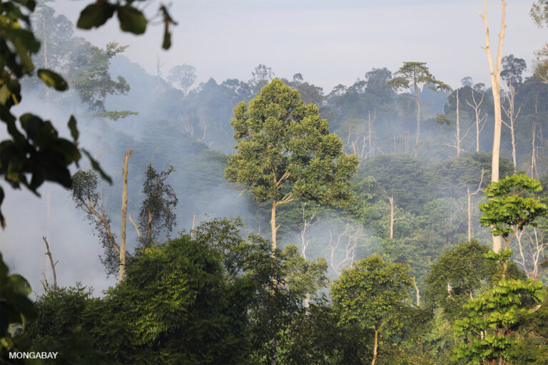
Banner image: Burned peat forest in Borneo. Image by Rhett A. Butler/Mongabay.
Related audio from Mongabay’s podcast: To understand what is being done to restore Indonesian peatlands, we interviewed the Deputy Head of the National Peatland Restoration Agency, Budi Wardhana, and Dyah Puspitaloka, a researcher on the value chain, finance and investment team at CIFOR, listen here:
Citations:
Terzano, D., Trezza, F. R., Rezende, M., Malatesta, L., Lew Siew Yan, S., Parish, F., … Attorre, F. (2023). Prioritization of peatland restoration and conservation interventions in Sumatra, Kalimantan and Papua. Journal for Nature Conservation, 73, 126388. doi:10.1016/j.jnc.2023.126388
Miller, M. A., Tonoto, P., & Taylor, D. (2021). Sustainable development of carbon sinks? Lessons from three types of peatland partnerships in Indonesia. Sustainable Development, 30(1), 241-255. doi:10.1002/sd.2241
Novita, N., Subarno, Lestari, N. S., Anshari, G. Z., Lugina, M., Yeo, S., … Ellis, P. (2022). Natural climate solutions in Indonesia: Wetlands are the key to achieve Indonesia’s national climate commitment. Environmental Research Letters, 17(11), 114045. doi:10.1088/1748-9326/ac9e0a
See related coverage by this reporter:
High-carbon peat among 1,500 hectares cleared for Indonesia’s food estate
FEEDBACK: Use this form to send a message to the author of this post. If you want to post a public comment, you can do that at the bottom of the page.
