- In 2018, a Mennonite colony purchased 14,400 hectares (35,500 acres) of land in the Bolivian department of Santa Cruz. Colonists have since built a bridge and developed a network of roads, and are in the process of clearing vast swaths of forest.
- The construction of the bridge appears to have been done without authorization from the government, and without an environmental impact assessment.
- Portions of the property lie within two protected areas: Kaa-Iya del Gran Chaco National Park and Integrated Management Natural Area, and the Bañados de Izozogy el río Parapetí wetland of international importance.
- Members of a local Indigenous community voiced support for the clearing activities, saying that the new roads and bridge will help connect them to medical facilities. However, scientists and conservationists are concerned about the impact of deforestation on water sources, wildlife and isolated Indigenous groups.
CUARIRENDA, Bolivia — In October 2020, residents of a Mennonite colony began clearing a road through the forest in the Cordillera province of the Bolivian department of Santa Cruz. By November, the road spanned about 5 kilometers (3 miles) and ended at the Parapetí River.
Satellite imagery from Planet Labs Inc and data from the University of Maryland (UMD) visualized on Global Forest Watch show clearing activity halted between November 2020 and May 2021. But in June 2021, road construction commenced on the other side of the river, and by July, a network of roads had been carved across approximately 100 square kilometers (37 square miles) of land.
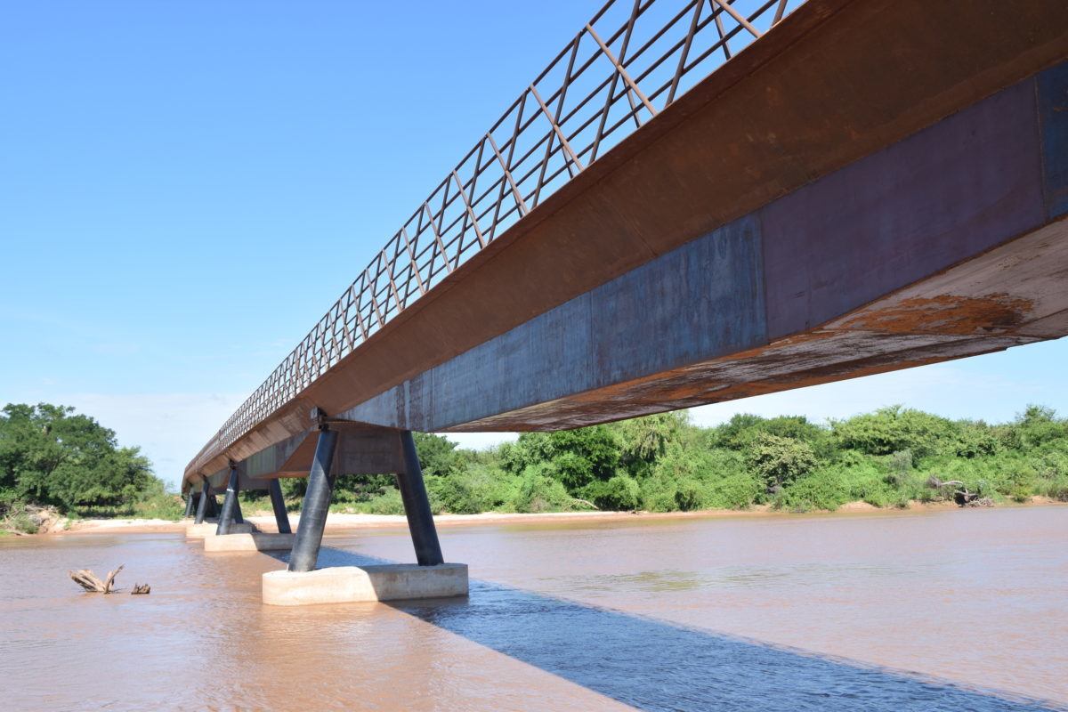
The network of roads appears to have been constructed in order to establish a vast plantation. Clearing between the roads began slowly in July 2021, but ramped up speed within a couple months, coinciding with the construction of a bridge across the Parapetí — allegedly done with without permits or a mandatory environmental impact assessment.

According to local sources, colonists purchased 14,400 hectares (35,500 acres) of land from a Bolivian businessperson in 2018, and the construction of the bridge was approved by members of a Guarani Indigenous community. However, conservationists are concerned about the increase in deforestation enabled by the bridge and its connecting roads, as well as its proximity to protected areas and sensitive wetland habitat.
The bridge spans some 150 meters (492 feet) and weighs around 150 metric tons. It lies a little more than 13 kilometers (8 miles) upstream from Cuarirenda, a town largely comprised of Indigenous residents. Jhonny García Melgar has been the communal leader of Cuarirenda for six years. He told Mongabay that the Cuarirenda community approved the bridge and road construction because it would make it easier for residents to access medical care.

“There’s a health post [on the other side of the river] and often we can’t take our sick people on the river, especially in the rainy season,” García said. “It isn’t only a benefit for the Mennonites but also for the community. We need this bridge more than ever and we want the authorities to sit down and legalize it.”
But García also expressed concern, saying there is no written documentation and that the project did not comply with environmental regulations.
“That was a mistake,” he said.
A threat to protected areas
Satellite data show a portion of the cleared area lies within the Kaa-Iya del Gran Chaco National Park and Integrated Management Natural Area, and sources say 7,000 hectares of the 14,400 hectares of land purchased by the Mennonite colony are also part of the Bañados de Izozogy el río Parapetí, which was designated a wetland of international importance in 2001 by the Ramsar Convention.

The vast agricultural clearings to which the bridge and roads lead are carved from Chaco dry forest, and conservationists are worried that sensitive wetland and river habitat may be affected if water is diverted for irrigation.
“The situation gets worse with the building of the bridge in Cuarirenda in the region of the Bañados del Izozog y rio Parapetí [Ramsar site],“ said Rosa Leny Cuéllar, the technical director of The Foundation for the Conservation of the Chiquitano Forest (FCBC) and coordinator of Sustainable Connected Conserved Ecoregions (ECCOS). “This wetland suffers the advances of Mennonite agriculture.”
Oswaldo Maillard, coordinator of the FCBC Chiquitano Dry Forest Observatory, warned that the Mennonite colony’s new cropland could have dire ecological consequences.
“The Parapetí and the Bañados de Izozog are very important. If the level of water is reduced, it will certainly affect other places,” Maillard said. “In addition, with deforestation, the forest is going to be fragmented, like an island disconnected from other ecosystems and that’s something that needs to be avoided.”
Colonial expansion
Mennonites are members of a conservative Christian group that was formed in Western Europe in the 16th century and which generally eschews certain types of modern technology. Families began immigrating to Bolivia in the mid-20th century, and by 2013 there were reportedly around 70,000 Mennonites living in 75 colonies across the nation. Mennonite colonies have been linked to large-scale deforestation for industrial agriculture in several Latin American countries.
Peter Martins is the minister, or leader, of the Mennonite colony in Cuarirenda. He said the bridge is safe and “necessary to bring supplies,” and that he doesn’t know if it violates environmental regulations.
“We asked lawyers if we needed a building permit. They said that an agreement with the Indigenous community was enough,” Martins said.
He added: “We wanted to respect [the environmental impact analysis procedure] but we didn’t know about it so we didn’t do it. Also, they told us it was enough to consult the community. We didn’t mean to break the law but we did it unknowingly.”
See related: Across Latin America, Mennonites seek out isolation at the expense of forests

A threat to water, wildlife and isolated Indigenous groups
According to FCBC’s Rosa Leny Cuéllar, the colony’s deforestation of the area will affect Kaa-Iya del Gran Chaco National Park and Integrated Management Natural Area, which is the biggest protected area in Bolivia. It is located in a transition zone between the Chaco and Chiquitania ecoregions, and contains major water resources.
That’s why Martins isn’t worried about water access for Mennonite colonies in the area. He said there is a 93-meter (305-foot) deep well on his plot and a goal to build 110 wells for the colony, adding that the colonists are already halfway to that target.
According to Bolivia’s National Service of Protected Areas (Sernap), the Parapetí Basin is of “extreme importance” because it contributes to the Bañados de Izozog wetland and other water sources in the region. The Kaa Iya del Gran Chaco protected area hosts a diversity of species:108 different kinds of mammals, 226 birds, 72 reptiles, 43 amphibians and 105 fish. It is also home to several species threatened with extinction, such as the Chacoan peccary (Parachoerus wagneri), the white-lipped peccary (Tayassu pecari) and the giant armadillo (Priodontes maximus).
Juan Carlos Catari of the Santa Cruz Association of Biologists said the columns supporting the bridge aren’t designed for a river and could block debris and other objects, which, in turn, could obstruct the flow of water. And both he and Maillard said that deforestation for roads and cropland have forced wildlife to relocate and may even pose a threat to isolated Indigenous groups.
“In addition, this great deforestation, with no permission [from the government], forces wildlife to move to other areas,” Catari said. “Even the isolated Indigenous communities are affected by the works.”

Leonardo Tamburini, director of Organización Oré, a group that offers legal assistance to Indigenous peoples in Bolivia, was also concerned that clearing by Mennonite colonists may threaten isolated Indigenous groups.
“We carried out a study about the sighting of Ayorea families in voluntary isolation, in coordination with institutions from the Paraguayan Chaco. All that region, like the Kaa Iya, Ñembi Guasu and Otuquis are sighting areas [where evidence of isolated groups were observed from afar],” Tamburini said. He added that these groups have the constitutional right to not be contacted by the outside world, a right that is protected by law.
A political quagmire
Jhannise Vaca Daza is an environmental activist and cofounder of the Ríos de Pie collective, a group that fights for the defense of the environment and Indigenous peoples in Bolivia. She described the bridge as a “monument to governmental uselessness” and urges that it be disassembled.
“The Cuarirenda bridge needs to be knocked down,” Vaca Daza said. “The bridge and deforestation are slowly killing the Bañados de Izozog and the thousands of species that have been living there since long before we named them. These wetlands are the biggest ones in the Chaco region, which is international. Every day that this bridge is still standing is one more day to confirm the State’s irresponsibility and corruption.”

Omar Quiroga, the director of the Bolivian Authority for Financial and Social Control of Forests and Land (ABT), said his office is investigating the situation near Cuarirenda.
“We are going to take action. One of them is carrying out an inspection to verify compliance with the planning instruments that have been approved, if they were approved,” Quiroga said. “Once we verify what’s happening on the field, we will take the administrative measures that are necessary, which could include annulling instruments if they were wrongly approved, paralyzing activities temporarily and doing what the law says.”
However, Tamburini of Organización Oré said ABT was present on-site when the bridge was being built in 2021 and was still unable to stop it.
“The [bridge] was built with national and regional bodies watching, but now they wash their hands because there hasn’t be a complaint able to stop the works,” Tamburini said.

Governor of Santa Cruz Luis Fernando Camacho visited the bridge in February 2022 and subsequently announced legal action against those who constructed it.
Edgar Montaño, minister of the federal government’s Public Works, Services and Housing ministry, blamed the department government of Santa Cruz for allowing the Mennonite colony’s infrastructure and land-clearing activities to continue.
“I have to say very clearly that, no matter who gets upset, the responsibility here lies in the governorate of Santa Cruz, because if there hadn’t been a report [from Bolivian media in 2021] no one would have known.”
This story was reported by Mongabay’s Latam team and first published here on our Latam site on March 16, 2022.
Banner image by Iván Paredes Tamayo.
Feedback: Use this form to send a message to the editor of this post. If you want to post a public comment, you can do that at the bottom of the page.