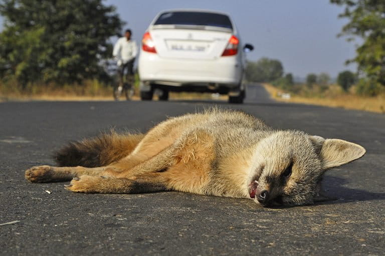
- Roadkills, a newly launched Android app, lets users in India record information on deaths of animals — both domestic and wild — on roads or railway lines, and upload geotagged photos.
- Such roadkill data can be useful for both researchers and people planning infrastructure projects across the country, conservationists say.
- The app data can help identify what sections of roads and railway lines animals use the most, for instance, which could in turn help guide measures that would reduce or prevent wildlife deaths.
- Warning: Some photos may be disturbing or graphic.
India’s growing network of roads and railway lines, often crisscrossing forests and wild lands, has turned deadly for wildlife. In December last year, for example, an 8-year-old male tiger died in a road accident on a four-lane-highway in the state of Maharashtra, while a speeding train killed five elephants in the state of Assam.
Countless other animals, from frogs and snakes, to birds and jackals, frequently collide with high-speed cars or trains in India, but their deaths go unnoticed, unrecorded.
A newly launched mobile-based app hopes to tackle this problem.
Roadkills, an Android app currently supported by the Wildlife Conservation Trust (WCT), lets people record information on deaths of animals, both domestic and wild, on roads or railway lines, and upload geotagged photos. Such data can be useful not just for researchers, according to Milind Pariwakam, a wildlife biologist with the WCT, but for people planning infrastructure projects across the country. The app data can help identify what sections of roads and railway lines animals use the most, for instance, which could in turn help guide measures that would reduce or prevent their deaths.
“Small research teams can only monitor a few roads at a time,” Pariwakam told Mongabay. “But development is going to happen everywhere, and the scale of this problem is so huge that resources are always going to be limited no matter how big an organization you are. So we thought ‘Why don’t we mobilize citizens to collect roadkill data instead?’”

Users can see all of the app data on a map on the Roadkills website. And those wanting to analyze the data themselves, or use it for other purposes, can write to the team, a press release notes, adding that “the data will be shared free of cost under a Creative Commons license.”
While the team’s long-term plan is to use the data to reduce roadkill, their immediate objective is to grow the user base and keep the users engaged. “Only then can data actually start flowing in and some action be taken,” Pariwakam said.
But users should be careful while using the app, he cautioned. “People drive fast on highways, which is also the reason for roadkills. So while recording a roadkill would be nice, your own safety is of utmost importance,” he said.
Stopping on some roads, such as parts of national highways that pass through some national parks, is also illegal. And people should be mindful of not breaking the law to collect data, he added.
The team is currently working on an iOS version of the app, which they say will be out within the next couple of weeks.
“We call upon other wildlife conservation organizations to join this initiative and make the data collection effort larger and more inclusive,” said Anish Andheria, the WCT president. “The data will be made available for better planning of roads and railway lines for a wildlife-friendly and better society.”


