- Historically, due to a lack of data, estimates of sun bear population trends have been little more than educated guesses made by experts. A major obstacle to monitoring population trends is that there are only a handful of sun bear-focused studies that collect data on population dynamics.
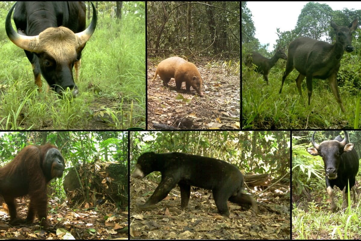
- Satellite imagery of tree cover change through time is available globally, as are bycatch camera trap data. There are many camera trap studies going on within the sun bear’s range that collect huge volumes of bycatch data, which are data on species that are not the primary focus of the study.
- With these tools at our disposal, it seemed that a more objective, data-driven measure of sun bear population trends was possible, and we believe that the innovate approach we ended up using has broad potential.
- This post is a commentary. The views expressed are those of the author, not necessarily Mongabay.
The sun bear (Helarctos malayanus), a charismatic tropical Ursid, occurs throughout Southeast Asia, where rapid deforestation and land-use change driven by human activities is threatening the future of this extraordinary species.
Historically, due to a lack of data, estimates of this bear’s population trends have been little more than educated guesses made by experts. The IUCN Red List assessment of sun bears’ conservation status, which was updated this year, relies on a single expert to ‘guesstimate’ population trends in some countries, and in others, such as Brunei, there were no estimates available at all.
A major obstacle to monitoring sun bear population trends is that some threats are impossible to quantify. No one knows how many sun bears are killed by humans each year, as all hunting of the species is illegal and therefore unreported except in rare cases when poachers are caught. Another obstacle to monitoring trends is that there are only a handful of sun bear-focused studies that collect data on population dynamics.
What is quantifiable is sun bear range, as sun bears live in tropical forests. With satellite imagery we can measure the extent of sun bear habitat as well as changes in the extent of that habitat over time. Furthermore, there are many camera trap studies going on within the sun bear’s range that collect huge volumes of bycatch data, which are data on species that are not the primary focus of the study. These data may have no value to the researchers who collected them, but may be useful to other people, for different reasons.
Satellite imagery of tree cover change through time is available globally, as are bycatch camera trap data from multiple study sites from within the sun bear’s range. With these tools at our disposal, it seemed that a more objective, data-driven measure of sun bear population trends was possible, and we believe that the innovative approach we ended up using has broad potential.
Using a massive conglomeration of camera trap bycatch data shared among multiple research groups and measures of tree cover change derived from globalforestwatch.org, myself and other researchers, from the University of Minnesota, the International Union for the Conservation of Nature (IUCN) Bear Specialist Group, and other leading conservation research organizations, modeled the relationship between sun bear detection rates and tree cover. Because there were no long-term camera trap studies from within a single study site, we used data collected from many different study sites, and we assumed that patterns across space reflected patterns through time.
We found that sun bears select for areas of high tree density. We estimated that if a patch of 80 percent tree cover was degraded into 20 percent tree cover, bear density in that patch would be reduced by almost 50 percent. These declines may be driven by several factors, including lower food supply, higher competition for resources, less shelter, and a higher risk of hunting by humans; all factors associated with degraded habitat. Using the relationship between sun bears and tree cover, we created the world’s first data-driven estimate of global sun bear population decline by inferring temporal trends in sun bear abundance in response to tree cover loss between 2000 and 2014.
Our findings, published in PLOS ONE, suggest that sun bear populations have likely undergone a significant range-wide decline. Casting our estimates forward 30 years from the year 2000, we project population declines of more than 50 percent in Malaysia and Indonesia. A decline of this magnitude puts the sun bear’s status within their southern range at the level of ‘endangered,’ according to criteria developed by the IUCN’s Red List of Threatened Species.
More than just revealing sun bear population trends, however, our study demonstrated the potential of camera trap bycatch data, which are accumulating in vast quantities through space and time. However, despite the potential uses of this data, analyses of this scale are rare. This rarity may be attributed to the inherent complexities involved in sharing and interpreting data among multiple research groups. During our study of sun bear population trends, it took us a long time to gather, sort, and combine datasets, and large quantities of data were lost due to deficiencies in data management techniques.
Therefore, in a second article, published in Remote Sensing in Ecology and Conservation, we highlighted the challenges we encountered while gathering and analyzing bycatch camera trap data from multiple projects. In this article, we aimed to draw attention to the problem of non-standardization of data management and poor data management in general, as well as to offer insights into how researchers can improve their practices to make it more practical for others to use their data for secondary research. We present a set of succinct, user-friendly recommendations to improve the management of camera data for future data-sharing efforts. Furthermore, our paper also includes a unique summary of the multiple tools and features associated with most current camera trap data management software platforms (e.g., software/internet requirements, data capacity, cost), allowing potential users to choose which software best suits their needs.
Our recommendations are broad — aimed, for instance, at individual researchers working with small data sets in simple spreadsheets and with no internet access, as well as at multi-collaborator projects that handle millions of images. We recommend that researchers adopt a non-proprietary and transferable data storage format to store data, instead of relying on excel, which may one day become obsolete (like the floppy disk). We also suggest that researchers accompany all data with metadata (i.e. the data about the data), a simple but crucial step that means deeply buried data can be interpreted in the future, without the need to contact the person who created the database. Our recommendations include further simple (but crucial) pointers on database structure, and how to store time, date, and geographical information — missing information on where the cameras were placed, when they were active, and for how many nights can render the data meaningless.
We also offer solutions for researchers overwhelmed with massive volumes of data, who may be forced to cherry-pick data of interest and leave bycatch data unclassified and never made publicly available. For example, there are several citizen science platforms (e.g. Snapshot Serengeti, Camera CATalogue, zooniverse.org) that feature innovative crowd-sourced solutions to handling massive volumes of camera trap images.
These publications join a growing global movement towards collaborative wildlife science and echo calls to improve the usability of camera trap bycatch data, to share data, and to further the ability to monitor threatened species with replicable, data-driven science.

CITATIONS
- Scotson, L., Fredriksson, G., Ngoprasert, D., Wong, W.M., Fieberg, J. 2017a. Projecting range-wide sun bear population trends using tree cover and camera-trap bycatch data. PLOS ONE 12(9): e0185336. doi:10.1371/journal.pone.018533
- Scotson, L. Johnston, L.R., Iannarilli, F., Wearn, O.R., Mohd-Azlan, J., Wong, W.M., Gray, T.N.E., Dinata, Y., Suzuki, A., Willard, C.E., Frechette, J., Loken, B., Steinmetz, R., Mossbrucker, A.M., Clements, G.R., Fieberg, F. 2017b. Best practices and software for the management and sharing of camera trap data for small and large scales studies. Remote Sensing in Ecology and Conservation, in early view, doi:10.1002/rse2.54
Lorraine Scotson, PhD, is a graduate from the Department of Fisheries, Wildlife and Conservation Biology at the University of Minnesota.