
- Illegal gold mining is commonplace in southern Peru, and is associated with massive deforestation and mercury poisoning amid other environmental and social concerns.
- Last year, analysis with Monitoring of the Andean Amazon Project (MAAP) started detecting mining activity within the northern boundary of Tambopata National Reserve.
- Satellite data indicate the mining is taking place in particularly pristine, connected tracts of primary forest.
- Tambopata’s forests are home to a plethora of wildlife, including endangered and endemic species.
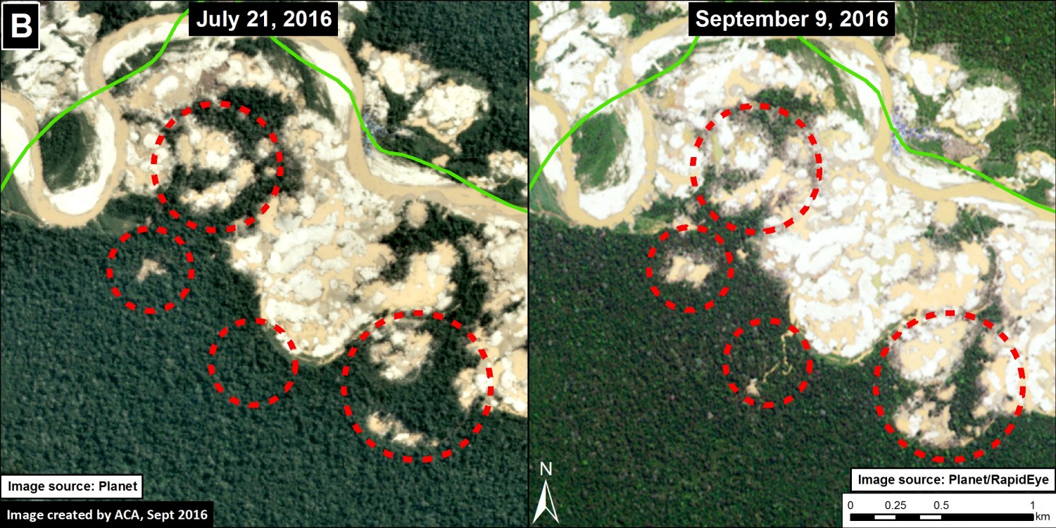
In the past two months, another 100 hectares of tropical rainforest have been demolished in Tambopata National Reserve, where deforestation from illegal gold mining in the reserve now exceeds 450 hectares – 4.5 square kilometers. This could mean trouble for the region’s wildlife – some 600 species of birds, 1,200 species of butterflies, and 200 species of mammals inhabit Tambopata.
Monitoring of the Andean Amazon Project (MAAP) has been monitoring Tambopata since November 2015, when deforestation was first detected within its borders. According to MAAP’s recent analysis, mining continues in four regions along the Malinowski River, which forms the northern border of the reserve. MAAP researchers quantified the recent uptick in mining-driven deforestation by analyzing high-resolution satellite imagery from July and September within the reserve.
According to Matt Finer, who heads up the MAPP project, illegal mining has a clear signature recognizable through satellite imagery.
“Mining has a very characteristic footprint [that can be detected in images] in relation to other drivers, such as agriculture and cattle pasture,” Finer said in an email to Mongabay.


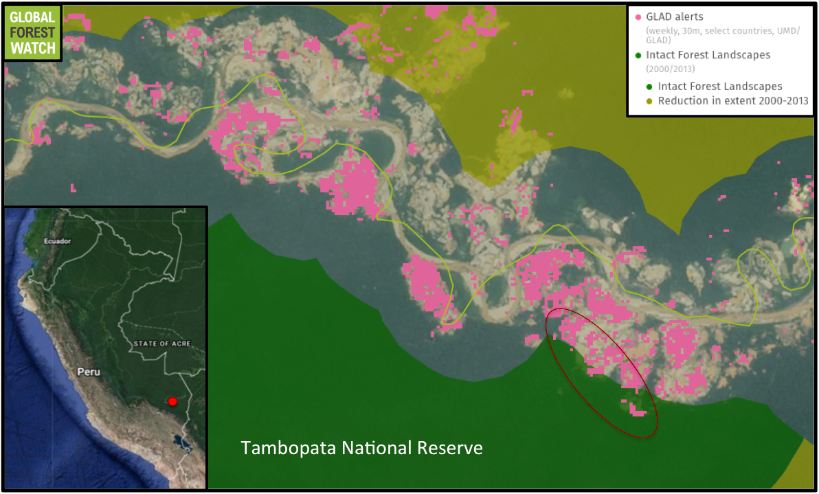
Analysis of the University of Maryland’s Global Land Analysis and Discovery (GLAD) dataset offers further evidence of the destruction within Tambopata. Since January of last year, more than 3,000 GLAD alerts have been detected in this small part of the reserve, each indicating an area where tree cover loss has likely occurred. A third of these were detected in the last two months alone.
Fresh GLAD alerts also show signs of continued forest loss within “Intact Forest Landscapes.” These areas represent unbroken expanses of primary forest, large enough to retain all native biodiversity. And there’s a lot of it in Tambopata. Drawing thousands of tourists every year, Tambopata provides refuge for around 600 species of birds, 1,200 species of butterflies, and 200 species of mammals – including the giant river otter (Pteronura brasiliensis), jaguar (Panthera onca) and other species already in global decline. Most species in Tambopata range only within the reserve’s intact forest – the very area illegal mining continues to shrink.
But the fallout from illegal mining in Tambopata is more than just an environmental concern. It’s also an issue of public health. Mining in Tambopata is contributing to the rise in mercury pollution – mercury is used to extract gold ore from sediment – in communities in and around the department of Madre de Dios. A heavy metal and deadly neurotoxin, mercury released from illegal mining sites may be impacting communities as far as 560 kilometers (350 miles) away.
Miners operate in Tambopata implicitly, but their presence is well known. Late last year, SERNANP – Peru’s National Protected Areas Service – warned that 2,000 illegal miners operating in the buffer zone had entered Tambopata, according to El Comercio, a leading Peruvian publication. But the number of miners in Tambopata may well number more than 2,000. Victor Hugo Macedo, head of the Tambopata National Reserve, estimates that around 5,000 people engaged in illegal mining activity – from sifting through sediment to transporting the gold around Peru – may be operating in the protected area, El Comercio reports.
Attempts to address illegal mining in Tambopata have been met with minimal success.
Soon after MAAP first detected deforestation within the protected area, the government stepped in, destroying mining equipment and thousands of gallons of fuel – typical tactics to stamp out illegal mining. But mere weeks after the government intervened, MAAP observed more forest loss. In another attempt to curtail illegal mining, the government installed a control post within Tambopata. Although the post was initially effective – installment was followed by a drop in deforestation – it was abandoned just months later for lack of resources.
Weeks ago, the post was reinstated.
“Reinstating the local control post is one of the most important steps to getting a handle on this crisis,” said Finer. “But it must be accompanied by the resources needed to permanently drive out the droves of illegal miners invading both the reserve and its buffer zone.”
MAAP will be monitoring the area closely over the next several months.
Citation:
- Finer M, Olexy T, Novoa S (2016) Gold Mining Deforestation Within Tambopata National Reserve Exceeds 450 Hectares. MAAP: #46
- Header image is of a margay (Leopardus wiedii) in Tambopata National Reserve, taken by Rhett A. Butler.