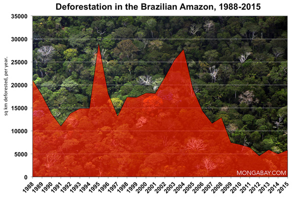
Brazil’s advanced satellite monitoring system, coupled with increased law enforcement, was responsible for nearly 60 percent of the 101,000 square kilometer-drop in deforestation observed between 2007 and 2011, argues a new study published an international think tank.
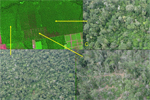
The analysis, conducted by the Climate Policy Initiative (CPI), assessed the influence of policy changes on the sharp decline in deforestation in the Brazilian Amazon since 2004. It used 2007 as the cut-off because that’s when the Brazilian government introduced DETER, a satellite-based monitoring system that can detect changes in forest cover on a monthly basis. The technology enables law enforcement officials from Brazil’s environmental protection agency, IBAMA, to take quick action against illegal forest clearing.
The study projected that some 100,000 sq km (38,600 sq miles) of Amazon forest would have been cleared over the five year period had there been no monitoring or law enforcement. It then calculated the impact of both monitoring and environmental fine collection by IBAMA, a proxy for law enforcement. To determine the effect of increased law enforcement, CPI included a scenario under which the rate of fine collection was help constant at the 2003 level. 2003 was the year before Brazil launched its Action Plan for the Prevention and Control of Deforestation in the Legal Amazon (PPCDAm).
CPI concluded that 59,511 sq km of the 101,073 drop in deforestation that would have otherwise occurred could be attributed to satellite-based monitoring and increased law enforcement. It estimated that had there been no law enforcement at all, some 164,290 sq km of forest might have been cleared.

Study lead author Juliano Assunção says the findings demonstrate the need to continue the programs.
“Brazil’s monitoring and law enforcement efforts are clearly playing a big part in preventing deforestation,” said Assunção, director of CPI’s Brazil operations and professor at the Department of Economics at the Pontifical Catholic University of Rio de Janeiro (PUC-Rio), in a statement. “Based on our analysis, we recommend maintaining these important policies and further improving monitoring technology to increase the effectiveness of law enforcement activities.”
The analysis also attempted to put a value of the programs.
“Ibama’s 2011 budget was USD 560 million, while INPE’s 2010 budget was USD 125 million. According to our simulation, command and control efforts preserved an average of 24,500 sq km of forest area per year in the 2007 through 2011 period. This area is equivalent to approximately 900 million tCO2,” wrote the authors. “Therefore, any price of carbon set above $0.76 per ton of CO2 would more than compensate the cost of environmental monitoring and law enforcement in the Amazon. Compared to the price of 5.00 USD/tCO2 commonly used in current applications, these figures suggest that the presence of an active monitoring and law enforcement authority in the Amazon has the potential to yield significant net monetary gains.”
Contrary to claims from Brazil’s agricultural lobby, the study found that the policy measures “had no effect on agricultural production.” Thus Brazil was able to reduce deforestation while simultaneously increasing food production and agricultural exports.
“This finding reinforces the case for relying on monitoring and law enforcement to protect the Amazon. Moreover, it indicates that, in the Amazon region, both preservation and economic growth can happen simultaneously, contrary to any perceived dichotomy between these two goals,” the paper concludes.
CITATION: Juliano Assunção, Clarissa Gandour, and Romero Rocha. DETERring Deforestation in the Brazilian Amazon: Environmental Monitoring and Law Enforcement. Climate Policy Initiative. May 2013
Related articles
Conflict zones have higher deforestation rates in the Amazon
(03/28/2013) Areas in the Amazon where there is conflict over land tenure have higher deforestation rates than places where land rights are secure, finds a new study that assesses the effectiveness of indicators used to gauge the success of protected areas in Brazil.
A promising initiative to address deforestation in Brazil at the local level

(03/05/2013) The history of the Brazilian Amazon has long been marked by deforestation and degradation. Until recently the situation has been considered out of control. Then, in 2004, the Brazilian government launched an ambitious program to combat deforestation. Public pressure—both national and international—was one of the reasons that motivated the government to act. Another reason was that in 2004, deforestation contributed to more than 55 percent of Brazil’s total greenhouse gas emissions, making Brazil the fourth-largest greenhouse gas emitter in the world.
Loans tied to environmental compliance reduced Amazon deforestation by 15%
(01/30/2013) A rural credit law that ties loans to environmental compliance made a significant contribution to reducing deforestation in the Brazilian Amazon between 2008 and 2011, argues a study published by the Climate Policy Initiative (CPI).
Brazil’s deforestation at record low from 2011-2012
(11/27/2012) Deforestation in the Brazilian Amazon fell to the lowest rate since annual record-keeping began in 1988 according to provisional data released Tuesday by Brazil’s National Space Research Agency (INPE). 1,798 square miles (4,656 square kilometers) of Amazon forest was chopped down during the 12 months ending July 31, 2012, 27 percent less than the year earlier period.
10 African countries to develop satellite-based deforestation tracking systems with help of Brazil
(07/30/2012) Ten tropical African countries will receive training and support to develop national forest monitoring systems, reports the United Nations. Brazil, which has an advanced deforestation tracking system, will guide the initiative in partnership with the Central Africa Forests Commission (COMIFAC) and the UN Food and Agriculture Organization (FAO).
Indonesia, Brazil, Mexico, Peru get big boost in deforestation tracking, biomass measurement
(07/11/2012) Efforts to rapidly and accurately track deforestation and forest degradation in Indonesia, Brazil, Mexico, and Peru got a boost this week with a special technical training session organized by the Governors Climate and Forest Task Force. The meeting, convened at Stanford University and Google’s Silicon Valley campus, paired staffers from government agencies and NGOs in the four tropical countries with technical experts from the Amazon Environmental Research Institute (IPAM), the Carnegie Institution for Science, the Forum on Readiness for REDD, Woods Hole Research Center, and Google Earth Outreach. The participants received training to augment existing deforestation, forest degradation and biomass monitoring capabilities, which are highly variable both between countries and within sub-national agencies and jurisdictions.
Near-real time Amazon deforestation alert system added to Google Earth Engine
(06/20/2012) A system providing monthly alerts on deforestation and forest degradation in the Brazilian Amazon will soon be generated on the Google Earth platform Engine, reducing the time it takes to process and disseminate data, reports Imazon, the Brazilian NGO that developed the Alert System of Deforestation (SAD).
Deforestation in Brazil’s Mata Atlantica drops
(06/06/2012) Deforestation of Brazil’s Mata Atlântica — a forest ecosystem more threatened than the Amazon rainforest — fell to 133 square kilometers between 2010 and 2011, down about 14.7 percent from the annual average between 2008 and 2010, reports Brazil’s National Institute for Space Research (INPE) and Fundação SOS Mata Atlântica.
Breakthrough technology enables 3D mapping of rainforests, tree by tree
(10/24/2011) High above the Amazon rainforest in Peru, a team of scientists and technicians is conducting an ambitious experiment: a biological survey of a never-before-explored tract of remote and inaccessible cloud forest. They are doing so using an advanced system that enables them to map the three-dimensional physical structure of the forest as well as its chemical and optical properties. The scientists hope to determine not only what species may lie below but also how the ecosystem is responding to last year’s drought—the worst ever recorded in the Amazon—as well as help Peru develop a better mechanism for monitoring deforestation and degradation.
Monitoring deforestation: an interview with Gilberto Camara, head of Brazil’s space agency INPE
(02/08/2011) Perhaps unsurprisingly, the world’s best deforestation tracking system is found in the country with the most rainforest: Brazil. Following international outcry over immense forest loss in the 1980s, Brazil in the 1990s set in motion a plan to develop a satellite-based system for tracking changes in forest cover. In 2003 Brazil made the system available to the world via its web site, providing transparency on an issue that was until then seen as a badge of shame by some. Since then Brazil has become recognized as the standard-bearer for deforestation tracking and reporting—no other country offers the kind of data Brazil provides. Space engineer Gilberto Camara has overseen much of INPE’s earth sensing work and during his watch, INPE has released several new exciting capabilities.
Google Earth to monitor deforestation
(12/10/2009) It what could be a critical development in helping tropical countries monitor deforestation, Google has unveiled a partnership with scientists using advanced remote sensing technology to rapidly analyze and map forest cover in extremely high resolution. The effort could help countries detect deforestation shortly after it occurs making it easier to prevent further forest clearing.

(09/29/2010) In recent years there has been an explosion in the number of satellite-based monitoring applications and technologies, which is perhaps best exemplified in the eyes of the public by Google Earth, which allows anyone with a decent internet connection to view overhead images of nearly any place on Earth. But these new applications are also helping scientists more effectively monitor environmental change, including the fluctuations in polar sea ice, shifts in oceanic plankton, and deforestation. An important factor in the expanded use of satellite imagery has been the U.S. government’s free Landsat Data Distribution Policy, which allows free or inexpensive access to data captured by Landsat satellites, which have been collected data on a regular basis since 1972. But the Landsat program is not presently operating at its full capacity, increasing the risk of a ‘data gap’ before a new system is in place in 2012.
How satellites are used in conservation
(04/13/2009) In October 2008 scientists with the Royal Botanical Garden at Kew discovered a host of previously unknown species in a remote highland forest in Mozambique. The find was no accident: three years earlier, conservationist Julian Bayliss identified the site—Mount Mabu—using Google Earth, a tool that’s rapidly becoming a critical part of conservation efforts around the world. As the discovery in Mozambique suggests, remote sensing is being used for a bewildering array of applications, from monitoring sea ice to detecting deforestation to tracking wildlife. The number of uses grows as the technology matures and becomes more widely available. Google Earth may represent a critical point, bringing the power of remote sensing to the masses and allowing anyone with an Internet connection to attach data to a geographic representation of Earth.
Development of Google Earth a watershed moment for the environment
(03/31/2009) Satellites have long been used to detect and monitor environmental change, but capabilities have vastly improved since the early 1970s when Landsat images were first revealed to the public. Today Google Earth has democratized the availability of satellite imagery, putting high resolution images of the planet within reach of anyone with access to the Internet. In the process, Google Earth has emerged as potent tool for conservation, allowing scientists, activists, and even the general public to create compelling presentations that reach and engage the masses. One of the more prolific developers of Google Earth conservation applications is David Tryse. Neither a scientist nor a formal conservationist, Tryse’s concern for the welfare of the planet led him develop a KML for the Zoological Society of London’s EDGE of Existence program, an initiative to promote awareness of and generating conservation funding for 100 of the world’s rarest species. The KML allows people to surf the planet to see photos of endangered species, information about their habitat, and the threats they face. Tryse has since developed a deforestation tracking application, a KML that highlights hydroelectric threats to Borneo’s rivers, and oil spills and is working on a new tool that will make it even easier for people to create visualizations on Google Earth. Tryse believes the development of Google Earth is a watershed moment for conservation and the environmental movement.