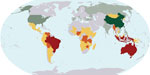
2.5-billion-ha carbon map shows forests store 250B tons of carbon
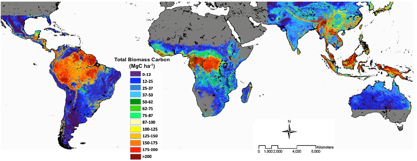
Forest carbon stock. Click image to enlarge
Tropical forests across Latin America, Africa, and Southeast Asia stored 247 gigatons of carbon — more than 30 years’ worth of current emissions from fossil fuels use — in the early 2000s, according to a comprehensive assessment of the world’s carbon stocks.
The research, published in the journal Proceedings of the National Academy of Sciences by an international team of scientists, used data from 4,079 plot sites around the world and satellite-based measurements to estimate that forests store 193 billion tons of carbon in their vegetation and 54 billion tons in their roots structure. The study has produced a carbon map for 2.5 billion ha (6.2 billion acres) of forests.
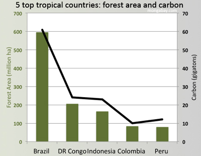
According to the study, forests in Latin America account for 49 percent of the total carbon stock, followed by forests of Southeast Asia (26 percent), and Africa (25 percent). Brazil’s forests accounted for nearly a quarter of total biomass measured in the study. Democratic Republic of Congo (9.8 percent), Indonesia (9.3 percent), Peru (4.9 percent), and Colombia (4.1 percent) rounded out the top five countries, which together accounted for more than half (52.8 percent) of tropical forest biomass.
 |
The researchers, led by Sassan Saatchi of Caltech’s Jet Propulsion Lab, used forest height data measured by the Geoscience Laser Altimeter System (GLAS) on board NASA’s Ice, Cloud, and land Elevation Satellite (ICESat) to model the distribution of above-ground biomass stored in forest vegetation. These estimates were calibrated using more than 4,000 on-the-ground research plots.
The paper notes that while more precise airplane-based systems for mapping carbon stocks have been developed, these are presently too expensive to implement on large scales. Therefore the authors say their map can be used for national- and project-scale assessments of greater than 10,000 hectares (24,700 acres).
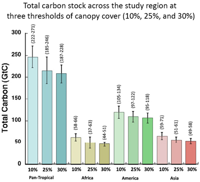
The study estimated carbon storage using three thresholds of forest cover: 10 percent, 25 percent, and 30 percent tree cover. Under the loosest definition (10 percent cover), forests were estimated to store 247 gigatons of carbon. Areas of forest with more than 30 percent tree cover stored 208 gigatons.
 |
The data for the study dates to the early 2000s — forest extent and biomass would be lower today due to deforestation. Nevertheless the findings could serve as a benchmark for efforts to measure reductions in greenhouse gas emissions under the Reducing Emissions from Deforestation and Degradation (REDD) program, which aims to compensate developing countries for protecting forests and peatlands.
“The benchmark map can also be used to assist countries in assessing the carbon emissions that are likely to be avoided by implementing different policies and programs aimed at reducing deforestation and forest degradation at regional and project scales,” the authors write. “The map will assist developing country governments, land managers, policy makers, and civil society to become more informed about the likely result of their policies and programs in reducing national greenhouse gas emissions from the land-use sector.”
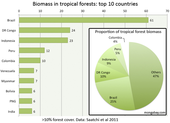 Estimates of forest carbon stocks in the ten largest national pools in the study region
CITATION: Sassan Saatchi et al (2011). Benchmark map of forest carbon stocks in tropical regions across three continents.” PNAS June 3, 2011.
Related articles
Global deforestation slows
(03/25/2010) Global forest loss has diminished since the 1990s but still remains “alarmingly high”, according to a preliminary version of a new assessment from the U.N. Food and Agriculture Organization (FAO). The report, Global Forest Resources Assessment 2010 (FRA 2010), shows that global forest loss slowed to around 13 million hectares per year during the 2000s, down from about 16 million hectares per year in the 1990s. It finds that net deforestation declined from about 8.3 million hectares per year in the 1990s to about 5.2 million hectares per year in the 2000s, a result of large-scale reforestation and afforestation projects, as well as natural forest recovery in some countries and slowing deforestation in the Amazon.
Temperate forests store more carbon than tropical forests, finds study
(07/17/2009) Temperate forests trump rainforests when it comes to storing carbon, reports a new assessment of global forest carbon stocks published July 14th in Proceedings of the National Academy of Sciences (PNAS). The findings have important implications for efforts to mitigate climate change by protecting forests. Sampling and reviewing published data from nearly 100 forest sites around the world, Heather Keith, Brendan G. Mackey, and David B. Lindenmayer of Australian National University found that Australia’s temperate Eucalyptus forests are champions of carbon storage, sequestering up to 2,844 metric tons of carbon per hectare, a figure that far exceeds previous estimates. These forests, located in the Central Highlands of Victoria in southeastern Australia, are dominated by giant Mountain Ash (Eucalyptus regnans) trees, which can reach a height of 320 feet and live for more than 350 years. They are also favored by the timber industry. Mountain Ash forests have been widely logged across Australia, with only limited old-growth stands remaining.
Rainforest conservation more important than developing electric cars
(01/01/2009) For all the fuss that is made about Tesla and the coming generation of electric cars, policy-makers should not overlook the importance of tropical forest conservation.
How satellites are used in conservation

(04/13/2009) In October 2008 scientists with the Royal Botanical Garden at Kew discovered a host of previously unknown species in a remote highland forest in Mozambique. The find was no accident: three years earlier, conservationist Julian Bayliss identified the site—Mount Mabu—using Google Earth, a tool that’s rapidly becoming a critical part of conservation efforts around the world. As the discovery in Mozambique suggests, remote sensing is being used for a bewildering array of applications, from monitoring sea ice to detecting deforestation to tracking wildlife. The number of uses grows as the technology matures and becomes more widely available. Google Earth may represent a critical point, bringing the power of remote sensing to the masses and allowing anyone with an Internet connection to attach data to a geographic representation of Earth.