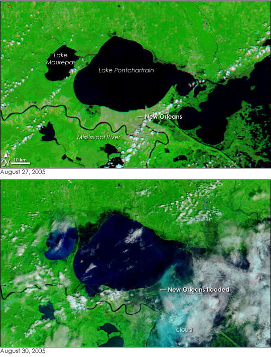
NASA releases satellite photos showing flooded New Orleans following Hurricane Katrina
NASA Release
September 1, 2005
NASA released satellite photos showing destruction caused by Hurricane Katrina. The images, available on NASA’s Earth Observatory web site clearly show signficant parts of the city inundated with flood water.

NASA also released the following text:
In the wake of Hurricane Katrina, much of New Orleans is under water in the top satellite image, taken on August 30, 2005, at 11:45 a.m. CDT by the Moderate Resolution Imaging Spectroradiometer (MODIS) on NASA’s Terra satellite. Early news reports say that as much as 80 percent of the city is flooded after levies failed to hold Katrina’s massive storm surge back. The flooding is getting worse as water slowly seeps into the city from Lake Pontchartrain.
On Saturday, August 27, 2005, New Orleans formed a tan and green grid sandwiched between the lake shore and the river in the lower image. Three days later, dark pools of water covered the eastern half of the city, and a large section of Lake Pontchartrain ballooned into the region immediately west of the city. Widespread flooding is visible elsewhere in the top image. Lake Pontchartrain and Lake Maurepas have nearly blended into a single body of water, separated only by a narrow strip of land. Dark smudges line the rivers flowing into both lakes, a sign that water covers the ground around them.
The images are shown in false color to make water visible against the land. Water is black or dark blue where it is colored with mud, vegetation is bright green, and clouds are light blue and white. The large images provided above provide a broader view of the region. They show flooding along the Mississippi and Alabama coast, particularly around Mobile Bay and parts of coastal Mississippi. The large images are at MODIS’ maximum resolution, but both the August 30 and August 27 images are available in additional resolutions from the MODIS Rapid Response Team.
NASA images courtesy Jeff Schmaltz, MODIS Land Rapid Response Team at NASA GSFC
The original release can be found here
This is a NASA news release.
Other hurricane information:
- Hurricanes getting stronger due to global warming says study August 29, 2005
Late last month an atmospheric scientist at Massachusetts Institute of Technology released a study in Nature that found hurricanes have grown significantly more powerful and destructive over the past three decades. Kerry Emanuel, the author of the study, warns that since hurricanes depend on warm water to form and build, global climate change might increase the effect of hurricanes still further in coming years.
- New Orleans Aquarium, Zoo escape Hurricane Katrina September 1, 2005
The Audubon Aquarium of the Americas in New Orleans apparently survived Hurricane Katrina relatively unscathed according to a report in The Baltimore Sun. Hurricane Katrina hit the Louisiana city Monday. - Environmental problems worsened Hurricane Katrina’s impact August 31, 2005
The loss of coastal marshlands that buffer New Orleans from flooding and storm surges may have worsened the impact of Hurricane Katrina. In the past, the region’s wetlands have served as a natural buffer that slows hurricanes down as they come in from the Gulf of Mexico and helps protect New Orleans from storms. But all this has changed.
- Hurricane news for individual counties and cities in Louisiana, Mississippi September 1, 2005
Hurricane Katrina left a path of destruction in its wake across Louisiana, Mississippi, and other southern states. If an effort to provide timely and location-specific information, below is a list of news article links for individual counties and cities across the region.
Other resources: - Aerial photos of Hurricane Katrina destructiont: NOAA posted online more than 1450 aerial images of the U.S. Gulf Coast areas that were decimated by Hurricane Katrina.
- Photos from inside Hurricane Katrina captured by NOAA plane: NOAA hurricane hunter WP-3D Orion and Gulfstream IV aircraft conducted ten long flights into and around the eye of Hurricane Katrina. Lt. Mike Silah, a P-3 pilot, got to see Hurricane Katrina up close and personal, especially when she was an extremely dangerous Category Five storm in the Gulf of Mexico.
- County updates


