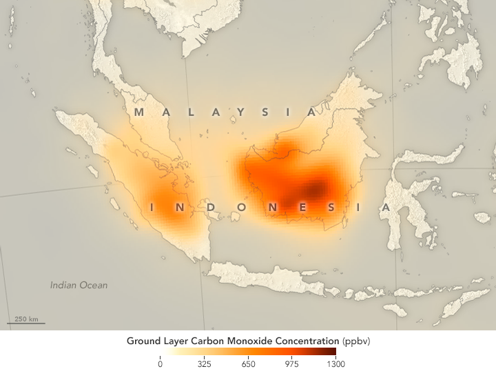
- A satellite detected “remarkably high” carbon monoxide levels in Sumatra and Kalimantan during Indonesia’s recent wildfire disaster.
- Concentrations in Central Kalimantan province were nearly 13 times the normal average.
- The invisible gas is poisonous to humans in large doses, though the precise health effects of the pollution from Indonesia’s fires remain largely unknown.
One of the most troubling unanswered questions hanging over Indonesia’s wildfire disaster is how it affects human health.
Researchers know that it does: as a result of this year’s crisis, 500,000 people suffered respiratory problems, and 19 people died. But the precise impacts of exposure to the gases released by the fires, most of which burn on dried peat soil, remain unknown.
Now, an image highlighted by NASA hints at just how bad it might be. The U.S. space agency’s Terra satellite shows “remarkably high” concentrations of carbon monoxide, a colorless, odorless gas that reduces oxygen flow to human organs when inhaled in large enough quantities.
In September, Terra measured ground-level carbon monoxide concentrations of up to 13 times the normal average of 100 parts per billion. The poison was most intense in parts of Borneo, where pollution from the fires turned the air ochre in October.
“The 2015 Indonesian fires produced some of the highest concentrations of carbon monoxide that we have ever seen with [Terra’s] MOPITT [sensor],” said Helen Worden, a scientist at the U.S. National Center for Atmospheric Research.
NASA isn’t the first to flag carbon monoxide from the fires. King’s College London professor Martin Wooster measured 30 parts per million in his hotel room in Palangkaraya, the capital of Central Kalimantan province – “enough to trigger a household carbon monoxide detector,” Thomson Reuters Foundation reported.
Someone just back from Palangkaraya: In Swiss bell hotel room we recorded 30ppm of carbon monoxide, above which you might not wake up
— Erik Meijaard (@emeijaard) October 25, 2015
The fires are an annual occurrence, with and companies using flames to clear land cheaply but often letting them burn out of control. This year’s disaster was worsened by a prolonged dry season due to the El Niño weather event.