- Satellite-based tracking tags, including ARGOS and GPS systems, collect and communicate animal locations and in some cases, acceleration and physiological data—straight to your computer, 24/7.
- ARGOS satellites use their relative position and the Doppler shift to estimate a tag’s location, which they relay back to Earth. GPS tags receive position information from multiple satellites and either store it or resend it via another communications network.
- Satellite-based tags weigh more, cost more, and demand more power than VHF radio tags. Nevertheless, they provide automated collection of thousands of point locations of an animal, which helps researchers to more precisely define home ranges, migration routes, and the relationships of these patterns to landscape features.
To understand the resource needs of a species, you need to know where individual animals go and what they do there. You can follow some animals around on foot or in a car, but you can’t follow a whale, a herd of migrating caribou, or a far-flying pigeon or parrot – they go too far, too fast, and in the wrong directions.
In the last Facts & FAQs post, we learned how researchers use radio transmitter to search for animals in the field and determine their locations. Improvements in communications technology, specifically transmission to and from satellites, have since revolutionized wildlife tracking.

Most satellite tracking of wildlife uses either the ARGOS (Advanced Research and Global Observation Satellite) or the Global Positioning System (GPS) satellite network. The two systems work in slightly different ways: ARGOS-based tags send information to their respective satellites, while GPS-based tags receive position data from their respective satellite network.
Both systems send information on tagged animals’ locations directly to researchers, rather than the researcher having to manually locate the “ping” of a VHF radio transmitter in the field.
How does ARGOS transmit to outer space and back?
ARGOS-based satellite tracking is similar to VHF radio tracking, in that a small electronic tag fitted to an animal sends out an electromagnetic radio signal, except that in this case the signal is sent to a satellite in outer space instead of to a radio receiver one, five, or 10 kilometers away.
The researcher programs the tag to send particular information—such as the time, date, latitude, longitude, animal’s ID, and quality of the transmission (to estimate position accuracy)—to the satellite network, like a mini satellite telephone.
ARGOS, launched in the 1970s, uses a Doppler system to determine positions. As the ARGOS satellite orbits, it picks up transmissions from a tag as it passes over the area and relays the positional and environmental information back to a data processing center on Earth. There, it estimates location using the change in the satellite’s position, its speed and distance from Earth, the frequency of signals, and the relative location of the tag in each signal. It calculates positions based on the change in frequency of an electromagnetic wave when the transmitter and receiver are in motion relative to each other, similar to how you hear a train going by. The processing center beams the information electronically to the researcher’s computer.
ARGOS uses polar-orbiting satellites, so tags at high latitude locations typically have better coverage than those near the Equator. It requires four or more transmissions to calculate the location, which may be more difficult in tropical locations far from the orbit.
So what is a GPS tracking tag, and how does it work?
A GPS-based tag receives radio signals from several of the GPS satellites that continually orbit the Earth. It calculates the tagged animal’s location by triangulating the position of three or more of these satellites. The more spread out the satellites, the more precisely the location can be estimated. A previous Mongabay-Wildtech post on real-time wildlife monitoring offers a primer on GPS tracking.
The GPS satellites continually transmit their positions, and the tag does the receiving. An “archival” tag collects and stores the positional and other data until you recover the tag from the animal. It doesn’t transmit information, so it needs minimal battery power and can be small. Since it doesn’t require a transmitter, it is generally the cheapest GPS option. You can also remotely (wirelessly) retrieve data from a GPS tag in several ways, listed by increasing coverage:
- A local remote network downloads to a base station (e.g. at a water hole) or to a handheld unit. The tag stays on the animal, and the transmission doesn’t need another communications network.
- Global System for Mobile (GSM) communications (a.k.a. cellular) networks, where available, offer ground-based communication to and from the tag via SMS or data links.
- For global coverage, the tag can transmit to a separate satellite network, such as Iridium or Inmarsat, which then beam the data directly to your computer. These data travel a long way!
So GPS-based tags and satellite-based tags aren’t the same thing?
Both GPS tags and satellite tags communicate with satellites, but one transmits, the other receives. An ARGOS tag transmits a signal and uses the relative movement of the satellite over a certain time period to determine the tag’s location. A GPS tag receives data from a certain network of satellites about their respective locations and calculates the tag’s location based on where these intersect. It needs the locations of three or more satellites to determine tag’s location.
Another difference is the frequency and precision of the data. ARGOS generally provides very few location estimates per day, so the tags can be much lighter than GPS tags. These estimates are typically less accurate: locations determined via ARGOS system’s Doppler shift have position errors upward from 250 meters, compared to the generally < 30-meter error of the triangulated position of a GPS receiver. A 250-1,500 m error would be acceptable for tracking a whale migrating across the Pacific Ocean but too high if you wanted to calculate an animal’s use of a forest corridor. The ARGOS platform now interfaces with GPS receiving tags, using the Doppler-derived locations as a backup.

GPS tags collect many thousands of accurate location estimations for the animal and transmit them to outer space. This requires a large battery, since a tracking tag cannot be recharged every night like the GPS in your car or running watch (see below). These tags are thus limited to use on larger animals.
Fitting an animal with either an ARGOS or GPS tag is similar to attaching a VHF radio transmitter tag. Research teams (on land) either trap smaller target animals or sedate larger ones to keep them still. While the animal is still or asleep, the team fits the tag using a collar, mini-backpack, ankle bracelet, or other device carrying the tag electronics.
What other information do GPS tags collect?
Designers of GPS tags and, increasingly, new ARGOS units, now embed sensors into the tags that measure physiological functions, such as heart rate and temperature. Accelerometers monitor the animal’s fine-scale body movements and, thus, the energy it expends.
Larger tags permit researchers to follow tagged individuals in real time and understand “normal” movement patterns, so that any unusual variation in movement—running fast or stopping for longer than expected—can trigger an alert and deployment of patrols to investigate.
What can I do with the data?
Researchers combine point locations retrieved from tracking tags (whether VHF or satellite) with other spatially-explicit data to make maps and tell stories about how specific animals move across the landscape. Plotting locations relative to landscape features—such as water, specific vegetation, soil types, human settlements, or other animals—helps in determining an animal’s resource needs and ranging patterns.
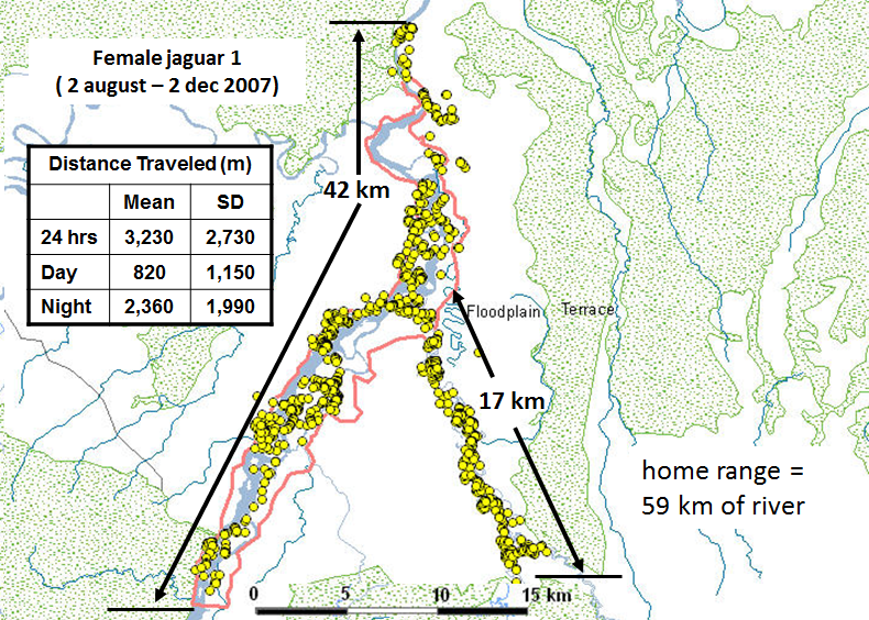
By providing thousands of point locations, a satellite-based tag helps researchers generate far more precise home ranges, travel distances, and other movement trends over a given day, season, migration route or year. Scientists tracking a herd of caribou learned that the animals move much more than previously thought and that each year the herd returns to about the same place each year to give birth. Collecting many point locations per day offers a far better chance of seeing rare behaviors (Kays et al. 2015), as well as learning where the animal is NOT going.
Scientists are increasingly sharing telemetry data via Movebank or other online data sharing and storing platform. Online data archives allow hard-won data to support management and conservation decision-making, reduce unnecessary data collection, and support multiple studies and education efforts. Academic departments, such as Wheelock College, encourage students to use tracking data in their research projects.
Very frequent point locations facilitate tracking species of concern, such as elephants, so parks can deploy patrols toward those areas for day-to-day management, not just research, and integrate location data with other technologies, such as virtual fences that warn villagers or managers of the presence of tagged animals. Early warning can speed response time of villagers to an approaching elephant or patrols to suddenly non-moving animals that may have been killed or injured. Similarly, large quantities of precise location information can be integrated with computer algorithms to recognize “typical” movement patterns based on previous behavior. Tags that stop moving or move too fast, too far, or away from “normal” areas all indicate abnormality that should be investigated.

Why don’t all research projects use GPS tags?
Good question.
The large number of point locations, collected in an automated and consistent manner, the additional types of data that can be collected, and the ease of receiving them straight onto one’s computer are huge advancements for wildlife movement research.
A tracking tag lightweight enough to be safely carried by the animal, cheap enough to put on many individuals, and able to transmit high-resolution data to a satellite so that it worked everywhere and did not need to be captured again would be used by nearly every research project. Unfortunately, this tag doesn’t yet exist, so scientists must make trade-offs between size, price, and amount and ease of data collection.
Tag battery life affects how researchers plan their data collection. Transmitting information from a tag on an animal up to a satellite and back to your computer requires power, traditionally in the form of a large, heavy battery. You cannot recharge a tracking tag every day like you do with your mobile phone. A heavier battery allows the device to produce stronger signals, send more signals per day, or last longer.

Battery weight has limited the use of satellite tracking to larger animals that could safely support the weight or to shorter studies. A majority of birds and mammals are too small to be tracked using current satellite tags (Kays et al., 2015), though this is changing.
The more transmissions a tag must send per day, the shorter the life of its battery. Archival tags that don’t transmit the information they collect can be smaller and lighter. Batteries on GPS tracking tags can also be less powerful if they need to send only to a relatively close cellular phone tower instead of a satellite orbiting hundreds of kilometers above the Earth.
To conserve battery life, some tags are programmed to transmit at a specified schedule, such as once per day, and some ARGOS transmitters can be programmed to turn themselves on and off (say, at night for a diurnal animal). Solar panels are increasingly being fitted to tags to power data collection and transmission and enable tags to be small enough to use with birds.
A satellite or GPS tag cannot tell you why the animal is doing what it is doing. You may know it is standing still, but not whether it is feeding, grooming/preening, or resting. A GPS tag that shows a lion staying in one spot for over two days could suggest it has a kill, but it won’t tell you what’s on the menu. Seeing the animal on the ground is still necessary to answer some research questions, though the tags can greatly assist researchers in finding and keeping track of study animals on a daily basis.

Cost is a significant trade-off for many projects. ARGOS and GPS tags cost roughly US $2,000 to $5,000, nearly 10 times what a VHF tag of similar lifespan costs. Their use also entails fees (~$500 per year) for communication with the satellites that the much simpler VHF radio tag does not incur.
The costs associated with attaching these tags— research team expenses, a vehicle, and travel to the animal’s location—are similar to attaching VHF tags. The higher costs of satellite tags reflect the extensive research and development time to support a relatively small user base, unlike an iPhone, which at least has a huge audience that reduces the per-unit cost. In turn, the high cost of GPS / satellite tags limits the number a given researcher can purchase, as well as the number of different uses of it she or she is willing to make.
The best available method for a given study would depend on the research questions, the size and movement patterns of the study animal, and the project budget.

REFERENCES
Tomkiewicz, S. M., Fuller, M. R., Kie, J. G. & Bates, K. K. (2010). Global Positioning System and Associated Technologies in Animal Behaviour and Ecological Research. Philosophical Transactions of the Royal Society B 365: 2163-2176.
(reviews GPS tag technology and uses)
Kays, R., Crofoot, M. C., Jetz, W., & Wikelski, M. (2015). Terrestrial animal tracking as an eye on life and planet. Science 348(6240), aaa2478.
(reviews advances in satellite tracking technology and uses)
Wilson, A. D. M., Wikelski, M., Wilson, R. P., & Cooke, S. J. (2015). Utility of biological sensor tags in animal conservation. Conservation Biology 29: 1065–1075.
(looks at various contributions that biological sensors embedded within tracking tags can make to conservation)