
 Tasmania's first specialty biodiesel plant has been approved, to start operating as early as July. The Macquarie Oil Company will spend half a million dollars on a specially designed facility in Cressy, in Tasmania's Northern Midlands. The plant will produce more than five million litres of fuel each year for the transport and marine industries. A unique blend of feed stock, including poppy seed, is expected to make it more viable than most operations.


New research to unlock potential of Ireland's maturing forest plantations

A critical mass of private and farm forestry is now developing in Ireland, with over 219,000 hectares planted since 1980. Many of these plantations are coming to the stage where decisions on management requirements need to be made. Currently, 105,000 hectares of private forests are over 10 years of age and 40,000 hectares are over 16 years of age.
The majority of private forest owners are farmers (84%). Recent research conducted by Teagasc and reported in the Small-scale Forestry journal indicates that if only 50% of private owners decided to thin their plantations, the annual output from farm forest first thinning could potentially rise to in excess of 200,000 cubic meters. This represents around 2.14 PJ worth of energy.
COFORD (National Council for Forestry Research and Development) estimates that the private sector’s market share will rise to 23% by 2015. However, the actual supply from the private sector is still far short of this target, with many farm forest plantations in Ireland currently unthinned for many reasons, including the high cost of harvesting, economies of scale, lack of knowledge about when to thin, and the price attained for farm forest produce.
While researchers have a general picture of the area of forest approaching first thinning age, there is very little information at a local level on exactly where the resource is located and which plantations are suitable for thinning in the next five to 10 years. In addition, there are few structures in place to quantify, locate or market the timber for owners, and there is a danger that the resource will be overlooked if the potential is not fully recognised.
It is timely then that Teagasc, with the support of COFORD, intend to conduct research to address critical issues facing farm forestry, such as the the lack of local level information about forests for specific market requirements. This research will address the critical issue of economies of scale among small forest owners. A cluster-based approach will be developed so that the management, thinning, harvesting and marketing requirements of farm forests can be achieved for a particular district. The outputs of this research should improve the ability of farm forest owners to market and sell their produce.
The work will quantify the material from farm forests by providing a methodology for assessment of the wood resource within any particular location, and link that resource to sawmills and bioenergy markets.
New methodology
 The ‘cluster’ methodology involves the capturing and compilation of highlevel inventory or growth information on forest plantations, using available database resources from the Forest Service, remotely sensed imagery such as aerial photography, satellite imagery and airborne laser scanning (LiDAR), and field-based measurements.
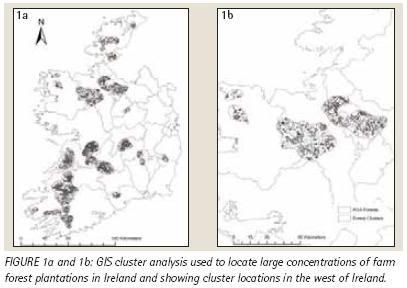
The first phase of the study utilises a geographic information system (GIS) in order to provide information about the location of forest plantations. The research uses a cluster approach performed in a GIS for locating areas with large concentrations of private forest cover (figure, click to enlarge). The method is extremely efficient in grouping large concentrations of forestry together and concentrates survey resources where forest cover has reached a critical mass:
 energy :: sustainability :: biomass :: bioenergy :: biofuels :: wood :: plantation :: forestry :: afforestation :: Ireland ::
 Forest clusters were identified at a national level based on two parameters: (1) private forestry in excess of 5% of the total land use; and, (2) cluster area greater than 10,000 hectares.
Some 16 separate areas matched these requirements spread throughout the country. It would appear from this preliminary analysis that private grant-aided (PGA) forestry does have spatial concentrations. A total of 42% occurs within identified cluster areas, while these cluster areas make up less than 14.5% of the total national land area.
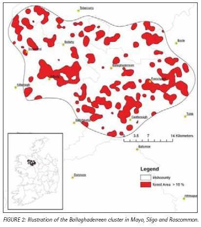 Of these cluster areas, four were identified as being priority areas. These priority areas include the Ballaghaderreen (example cluster, click to enlarge), Glenamoy, Bellacorrick and Leitrim clusters. These areas were chosen based on the initial intention of this research programme to concentrate on the west of Ireland. Therefore, 10% of PGA forestry will be assessed by concentrating resources in only 0.3% of the national land area.
Remote sensing methods
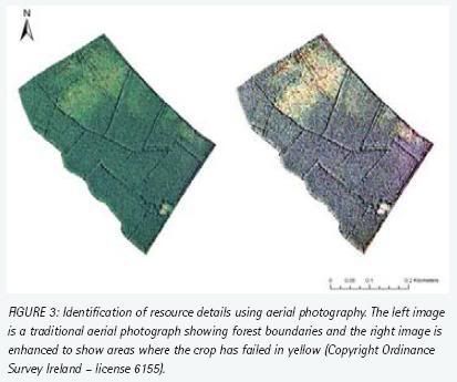 Work is underway in identifying the best available methods for determining forest stand parameters. The latest aerial photography is being used in order to capture value-added data about plantations in the cluster areas. This involves determining field boundaries, identifying development stage and stocking levels, and providing information on roadways and access (figure, click to enlarge).
This will be further aided by SPOT satellite imagery, which will be made available from the Teagasc Spatial Analysis Unit in 2008. The potential of LiDAR (Light Imaging Detection and Ranging) in obtaining stand-related parameters is also being assessed. LiDAR is a remote sensing system, which appears to have great applicability for the estimation of canopy height models that can be used to estimate other forest parameters, such as stand heights, stand volume and the structure of the forest canopy. In turn, canopy structure gives vital information on stocking density and wind damaged areas. Therefore, this research will evaluate the potential of these new technologies for analysing species, spatial distribution, monitoring forest cover fragmentation, planning of forest road networks and the monitoring of forest land cover change.
Field assessment and production forecast
All plantations within a cluster that are approaching first thinning stage or have passed first thinning stage (or a certain age criteria) will be visited in the field, where an assessment of timber quality and volume will be performed in each stand using tried and trusted forest sampling methods. The field survey will be based on capturing forest growth parameters. All the data will be compiled into a field database and the volume of each stand will be computed using the COFORD Dynamic Yield Model ‘Growfor’.
These models will be used to generate forecasts of volume production by projecting the growth of stands forward to a reference age and quantifying the effects of thinning a crop. A forecast for timber production for each stand in the cluster will be made and will be used as the main tool for further development work, especially in the identification of suitable locations for new market opportunities.
Further analysis will be performed using GIS technologies such as: distance from sawmill; optimum haulage route; and, optimising the location of additional wood utilising facilities such as wood energy boilers.
The Cluster Research Programme has been part-funded by the Council for Forest Research and Development (COFORD). This work is also funded by the Teagasc Core Programme.
References:
Niall Farrelly, Brian Clifford and Stuart Green. "Unlocking farm forest potential", TResearch, Volume 3: Number 1. Spring 2008, pp 22-25.
AlphaGalileo: Teagasc research news - unlocking farm forest potential, buffering market volatility, disability on Irish farms and reducing labour inputs for calving and calf feeding - February 26, 2007.
posted by Biopact team at 6:21 PM
![]()
![]()


0 Comments:
Post a Comment
Links to this post:
Create a Link
<< Home