- Spread across highland forests, tropical steppes, and low-lying floodplains — all of which are affected by varying degrees of human influence — the Amazon is a complex ecosystem. Yet, it remains inadequately mapped.
- Considering the degree of threat facing the Amazon and its global importance, it is critical to develop better methods for monitoring and comprehending this ecosystem.
- Carlo Ratti, the director of MIT’s Senseable City Lab, and Robert Muggah, the co-founder of the Igarapé Institute, argue that creating a “digital twin” of the Amazonian ecosystem could potentially serve as a means to aid its preservation while fostering a regional bioeconomy.
- This post is a commentary. The views expressed are those of the authors, not necessarily of Mongabay.
The Amazon – spread over half of South America and filled with thousands of unique species and billions of trees – is being ravaged by global demand for beef, soy and mineral commodities. But reversing its deforestation and degradation will not be achieved by a narrow focus on conservation. This is because the Basin is home to over 30 million people, many of whom depend on ranching, farming and mining to survive. Using data and digital tools to map the relationship between the forest and its inhabitants is far from straightforward – but leveraging the latest cartographic innovations can probably help us keep one of the planet’s vital carbon sinks from tipping.
The Amazon is a bewilderingly complex ecosystem. Spanning over 7 million square kilometers, it is the largest and most biodiverse tropical forest in the world. Home to nearly 400 billion trees (40 for each human on Earth) and over 16,000 species, it is spread across highland forests, tropical steppes, and low-lying floodplains. However, it is not a primordial, untouched landscape: Tens of millions of people, including over 350 distinct ethnic groups, live there, in settlements ranging from tiny villages to teeming cities. Despite facing monumental threats from deforestation, insecurity, and inequality, the Amazon remains one of the world’s least surveilled and mapped environments. Yet, we can change this situation, thanks to a new generation of cartographic innovations driven by digital technologies.

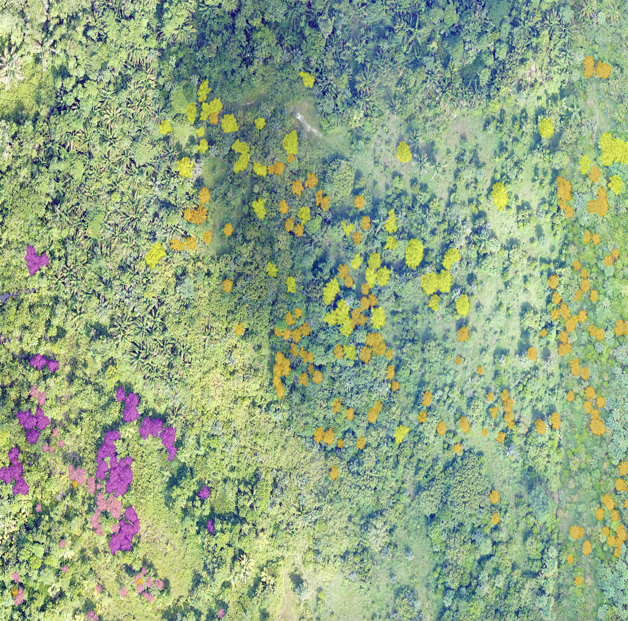
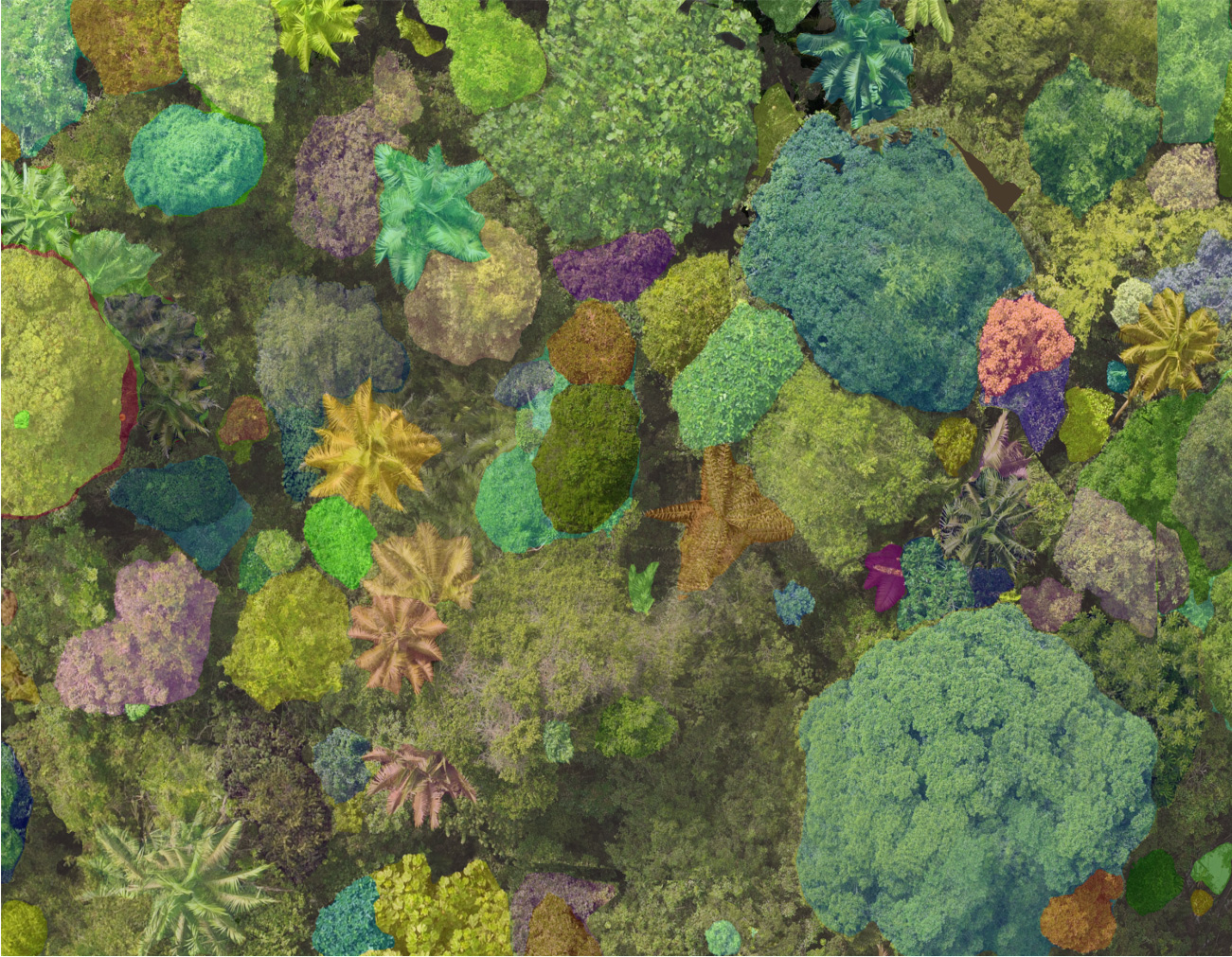
Mapping a rainforest as vast and diverse as the Amazon is an exceptionally challenging endeavor. While human settlements tend to remain relatively static, with roads, buildings, and infrastructure following fixed grids, the rainforest is subject to significant seasonal changes that profoundly affect canopy cover and river flows. Within days of producing maps using remote sensing tools, the landscape often undergoes rapid alterations, such as an illegal mine appearing or a forest fire breaking out, causing the mapping efforts to be constantly in flux. This is where digital twins, utilizing real-time Light Detection and Ranging (LiDAR) and satellite data, provide transformative opportunities.
What exactly is a digital twin? It can be thought of as an enhanced form of cartography, effectively transforming a building, sewer system, or rainforest into a digital environment for streamlined monitoring and management. NASA started using digital twins in the 2000s to help create simulations, with engineers replicating systems on Earth to mimic conditions in space. Over the past two decades, digital twins have evolved into a cornerstone of ‘smart city’ planning, aiding architects, urban planners, businesses, and civic groups in comprehensively mapping and comprehending existing cities while envisioning the cities of the future.”
For instance, 3,000 kilometers south of the Amazon, one of us (Carlo Ratti) utilized LiDAR scanning to map Rocinha, one of the largest ‘favelas’ or informal slums, situated on the outskirts of Rio de Janeiro. Working with Washington Fajardo and the mayor’s office, we were very optimistic about the practical improvements the city could one day make as a result of the detailed three-dimensional map we had created. Equipped with more granular data, the legal system could help residents register their affiliation or ownership of properties, for example, while utility companies could identify areas without access to the municipal energy supply. By literally putting favelas on the map, we could help secure a better life for their residents.

In a similar way, digital maps can help understand the forest ecosystem in more detail than ever before. Scientists are already using LiDAR. For example, the Earth Archive has assembled a number of partners including the Brazilian Space Agency (INPE), Mapbiomas, and several Brazilian universities to generate high-resolution scans of the rainforest. In the future it will be theoretically possible to map not just every single tree from crown to roots, but also scan the ways different tree species are connected to the surrounding topography and how each one generates effects on the land around them.
By helping expand situational awareness of the Amazon Basin, digital twins can help protect the ecosystem from environmental crime and unsustainable development. Similar tools are already providing indigenous groups with powerful knowledge to prevent selective logging, illegal wildcat mining, and poaching on their lands. Simulations using data collected in digital twins can also potentially help to identify which regions are most at risk of ‘die-back’ and ‘savannization’, the process by which a forest, deprived of water and trees, becomes a sterile grassland.
What is more, digital twins can help clarify the relationships between the rainforest ecosystems and the many cities nestled within them. Over 80 percent of the Amazon Basin’s inhabitants live in urban areas, including in large cities such as Belem and Manaus in Brazil, Leticia in Colombia, and Iquitos in Peru. These cities include complex and informal neighborhoods that remain unmapped, making it harder to balance the delicate dance of development, welfare and environmental protection. But digital twins can help penetrate the complexity of the forest and the city alike.
Digital twins are already enhancing the monitoring and expansion of sustainable agroforestry activities in the Amazon, helping make them scalable, profitable, and sustainable all at once. One forest data company called Bioverse (co-founded by one of us, Robert Muggah), combines remote sensing data with advanced machine learning to identify and scale-up investment in non-timber forest products such as acai, cupuacu and Brazil nuts. Working with local residents, including indigenous and Quilombo harvesters, Bioverse identifies products to harvest and sustainably grow supply chains for food, cosmetics, and pharmaceutical production. Bioverse is also testing the use of LiDAR data to scan the forest’s structure and functions, including critical hydrology, geochemistry, and biodiversity.


Nevertheless, there are potential risks to consider. The power of digitally-enabled sensing tools can be harnessed by anyone with the resources to collect data – for good or ill. The same tools that can help expand a green bioeconomy can also help illegal loggers and miners chase the biggest windfalls. There are risks that satellite data could empower malign actors to surveil and oppress indigenous groups, many of whom are the most important defenders of the forest. In the wrong hands, a digital twin could easily become an evil twin; it will take careful regulation to prevent this.
But if we want to genuinely protect and preserve the Amazon rainforest and improve the lives of its people with sustainable alternatives to the extractive industries, we need to see it more clearly–to allow more sunlight to penetrate the canopies and assist us in comprehending the intricate environment below. Better measurement is the key to better management. As French oceanographer Jacques Cousteau famously said, “People protect what they love, and they love what they understand.”
Carlo Ratti is the director of MIT’s Senseable City Lab. Robert Muggah is the co-founder of the Igarapé Institute and a co-organizer of TEDxAmazônia.
See related coverage:
Sound recordings and AI tell us if forests are recovering, new study from Ecuador shows