
- After a pause of more than 10 years, road upgrading through Katavi National Park has restarted.
- Critics worry about the possible effects on long term conservation of protected wildlife populations in the park, the loss of thousands of trees, and a decline in tourist revenue.
- “Once the road is paved, it will never be unpaved. Instead, a compromise solution lies in sensitive thinking of where the large mammals collect,” a wildlife biologist argues in this commentary.
- This post is a commentary. The views expressed are those of the author, not necessarily Mongabay.
Katavi National Park is one of the great East African parks. It’s great in the sense of being an enormous, 4,471 km2 area of miombo woodland, having a high diversity of large mammals and bird species, and high densities of large mammals (it is renowned for its hippopotamus and crocodile populations). Widely regarded as Tanzania’s wilderness park, photography-oriented tourists visiting Arusha – Tanzania’s tourist hub – looking for a ‘classic remote experience’ are encouraged to spend three days there, despite the exclusive, 3-hour flight in a light plane.
Yet the park is under pressure from a two-decade-long wave of pastoralist immigrants settling south of the park. Tree felling, charcoal production, and small-scale agriculture has now converted the southern boundary into a hard edge, and increased the population sizes of villages south of the park.
Fifteen years ago, the dirt road from Sumbawanga – the Rukwa regional capital – was upgraded to bitumen, but stopped south of the park and instead skirted its southern border from Kisi to reach the village of Kibaoni (see map). The road from Mpanda, the capital of Katavi region to the north of the park, was also upgraded, but again stopped at the park headquarters at Sitalike. The park looked as if it was saved from the fate of Mikumi National Park in central Tanzania, which has a blacktop highway running all the way through it.

Mikumi is instructive here. Despite gates at each end of the park – which are unmanned, allowing one to drive through without stopping, and 11 speed bumps – animal mortalities on the paved road are high: 111 mammals, 55 birds, and 183 reptiles documented killed in a 15-month period. Subsequent research showed, over an 11-year period, 456 mammals killed, 135 of which were buffalo, 17 elephant, 17 giraffe and 3 hippopotamus. Vehicular damage and human injuries are inevitable outcomes.
Yet Mikumi has far lower mammal densities than Katavi and its paved road crosses no animal watering hotspots. Tarmac also shatters a tourist’s idea of a pristine national park and degrades their experience, lowering their probability of revisits or making positive recommendations. Mikumi is regarded as a cheap tourist option and yet still receives visitors because of its proximity to Dar es Salaam. Katavi is too far away to capitalize on its location.
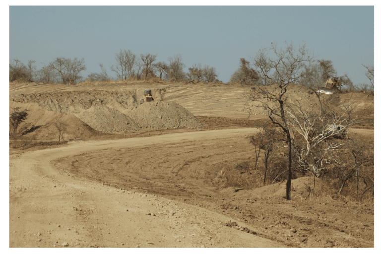
Now, road upgrading has started through Katavi National Park. Instead of choosing the westerly route which has relatively low large mammal densities throughout the year, or skirting the park altogether (see map), the authorities have chosen to run the road through the center of the park right across the dry season large mammal hotspot of the Katuma River and Ikuu bridge.
This hotspot is the reason that four tourist camps have been established nearby, and why tourists visit the park. Calculations show that a minimum of 188,000 trees along the 46 km stretch through the park will be cut as a result of very extensive road widening which the Tanzanian Road Authority (TANROADS) still deems necessary for road construction, and removing trees that might fall. The width of habitat removed on both sides of the road by the Chinese company that won the tender on this project are just as they were 20 years ago, and have failed to catch up with 21st century sensitivities about the carbon footprint.
Mammal and bird population densities are always lower near to highways, either because of avoidance or increased mortality. Birds are affected up to 1 km away from a road, mammals up to 5 km away. Therefore, a 46 km stretch of upgraded road affects mammals over an area of 460 km2 (46 x [5+5]) which amounts to an area of 10% the size of Katavi National Park.
Tanzania National Parks (TANAPA) is relatively powerless in the face of TANROADS decisions, and are instead planning to erect gates at both ends of the park, and have requested speed bumps. While these may be helpful, the Mikumi experience suggests they will not prevent human and wildlife mortalities due to an uptick in heavy traffic preferring the paved road over the murram (gravel) alternative, and traffic racing between speed bumps – as well as extensive littering, and an inevitable increase in bush fires.
Why was this decision taken against conservation advice? Almost certainly due to political expedience – the citizens of Kibaoni to the south of the park (see map) and their political representatives wanted a fast way to reach Mpanda, so as to sell and buy products from the regional hub. They traded tourist revenue to the nation and ecosystem services that the park provides for trying to raise people out of poverty. As in so many other cases, short term expediency has trumped long term financial gains, with little regard to Tanzania’s natural capital.

The actions of these politicians reveal that they are not thinking of themselves as stewards of Tanzania’s natural heritage, guardians of a carbon sink, contributing to the mental health of future generations of Tanzanians that will enjoy wild places, nor that they have factored in the benefits of tourist-based revenue.
Is there a way to reconcile these two opposing objectives? While the tree felling and bulldozing are smashing through the park center as I write, eventually trees and bush will grow back. But once the road is paved, it will never be unpaved. Instead, a compromise solution lies in sensitive thinking of where the large mammals collect (keeping the road as gravel five miles north and south of the sensitive dry season large mammal hotspot, for instance).
If murram is left intact and not paved, from five miles north of the Katuma River crossing at Ikuu to five miles south, wandering elephant, zebra, waterbuck, lions and crocodiles at the dry season water resource will stand a chance against slowed traffic. Crucially, nocturnal grazing hippopotamus will not be knocked down by speeding night-time trucks and buses. A compromise will allow tourists to still enjoy wildlife without the noise of racing vehicles. Meanwhile, drivers can pick up speed over tarmac north and south of the wildlife area to get their goods to their destinations on time.

Such a change will necessitate brave Tanzanian politicians in a high positions to stick their necks out and overrule others with shorter term political and financial interests. They will need to argue that saving Tanzania’s natural capital for future generations, and accruing tourist revenue over the long term, are more sustainable ways of nation building than linking two economically marginal regions at high speeds.
But is time is very, very short before the asphalt paving equipment moves in.
Yet it can be done.
Tim Caro is a behavioral/evolutionary ecologist and conservation biologist who has conducted research in Katavi National Park for 20 years.
Banner image: Katavi National Park, courtesy of Tim Caro.
Related audio from Mongabay’s podcast: A discussion of finance schemes aimed at protecting Africa’s largest swath of forest with experts from UNDP, CIFOR and more, listen here:
See related reading:
From cardamom to carbon: Bold new Tanzanian project is regrowing a rainforest
Wild mushroom harvest helps keep trees standing in Mozambique