- Kirindy Mite forest is a unique ecosystem that is home to three of Madagascar’s six endemic species of baobab trees.
- The forest is facing increasing anthropogenic pressure, especially from bushfires.
- Mongabay spoke with Diamondra Andriambololona, the director of Kirindy Mite National Park in southwestern Madagascar and the nearby Andranomena Special Reserve, about how the increase in fires is affecting the region’s unique forest and what is being done to reduce them.
- “The pressures on the forest will continue to increase as long as the people remain poor,” says Andriambololona.
MORONDAVA, Madagascar — As the director of Kirindy Mite National Park and Andranomena Special Reserve near Madagascar’s southwestern coast, Diamondra Andriambololona oversees the protection of nearly 162,770 hectares (402,213 acres) of biodiversity. The forests there are facing increasingly extreme anthropogenic threats, exacerbated by local poverty.
Kirindy Mite National Park, near the village of Belo-Sur-Mer, 80 kilometers (50 miles) south of the town of Morondava, has both a terrestrial and a marine component. Together, they form an ecosystem as extraordinary as it is fragile. The forest is home to three of the country’s six endemic baobab species (Adansonia grandidieri, A. za, and A. rubrostipa) — unique trees that look as though they were planted upside down. Many other endemic species live there, too, such as the critically endangered Madame Berthe’s mouse lemur (Microcebus berthae).
This biodiversity hotspot is facing heavy threats from bushfires, used to manage arable land and pastures, that illegally breach the park’s boundaries. Other issues, such as illegal logging and poaching, also threaten the forest, but fire is the main driver of forest degradation. The forests in southwestern and western Madagascar — xerophytic and deciduous dry tropical forests, respectively — are particularly vulnerable to bushfires.
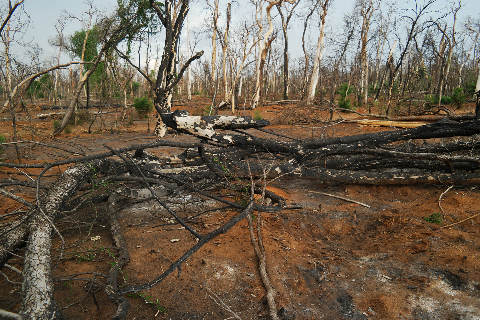
Many farmers in the country still practice slash-and-burn farming. They clear and burn plots to prepare their fields before the rainy season begins. Although the practice is generally prohibited due to its unsustainability, and efforts are being made to raise awareness, it remains an accessible solution amid a lack of fertilizers and tools needed to prepare fields. These fires can get out of control, and they burn thousands of hectares of forest each year.
Madagascar’s bushfire season lasts from July to November or December, when the first rains fall. A high number of fire alerts were recorded around mid-October 2022, with the highest intensities recorded on the west and particularly southwest sides of the island. According to Global Forest Watch, from 2001-21, this region of the country lost a yearly average of nearly 6,530 ha (16,135 acres) of forest to fires.
Jérémy T. Ranjatoelina, president and co-founder of Dry Forest, an NGO dedicated to reforestation in Kirindy Mite National Park, told Mongabay he believes anthropogenic pressures were what caused the separation of the forest in Kirindy Mite National Park from that in Kirindy Forest Reserve, which is located farther north. These two forests, which were previously one, are evidence of the severity of forest fragmentation in the region.
The municipality of Belo-Sur-Mer is somewhat isolated from the rest of the island. Especially during the rainy season, its inhabitants depend on natural resources (predominately wood, salt and fishing) and on tourism. This isolation can sometimes hinder the protection of the park, most of which can only be monitored in portions. The communities there are also very poor. According to a field representative from Dry Forest, residents earn just 5,000-10,000 ariary a day (about $1-2) — and that’s on a good day.
According to Andriambololona, who works for Madagascar National Parks, the quasi-state entity managing Kirindy Mite National Park and the Andranomena Special Reserve, out of the terrestrial portion of the park’s total area of 120,000 ha (296,500 acres), 80,000 ha (197,700 acres) of forest remain. However, he said losses are trending downward. Between 2017 and 2022, annual losses averaged 120-150 ha (296-370 acres), while recently they’ve declined to 100 ha (247 acres).

Mongabay interviewed Andriambololona in November 2022, near the end of a long bushfire season. The conversation took place during a meeting at a restaurant in Morondava, where the reporting team was making a stopover prior to the five-hour sea crossing to Belo-Sur-Mer. This interview was combined with subsequent conversations held by phone and email in April of this year. It has been lightly edited for clarity.
Mongabay: Many fire alerts have been recorded across Madagascar. What is the situation in Kirindy Mite National Park?
Diamondra Andriambololona: Like many other protected areas in Madagascar, we have not been spared from bushfires. We don’t have exact forest loss figures yet, but I think there were fewer fires [in 2022] than in 2021.
Mongabay: What are the main challenges in fighting forest fires in Kirindy Mite National Park?
Diamondra Andriambololona: First, the main causes of bushfires are pasture renewal and farming. Farmers are preparing their fields for the agricultural season, and they sometimes lose control of the fire.
The problem is that on this part of the island, fires can start very quickly due to the hot and dry weather, and the vegetation here is dry as well. With the wind, fires can spread very rapidly, and what’s more, they can be difficult to put out.
Poaching can also cause bushfires. Poachers use fire to trap wild boars or guinea fowl. Once their quarry is caught, they don’t put out the fire. This often occurs during lean seasons when there are no harvests. Without income and driven by hunger, people enter the protected area to hunt what they can.
It is also important to know that cyclones are more damaging to baobabs than fire. We also see tree cover loss due to land clearing, but there are only a few who practice that in Kirindy Mite park.

Mongabay: What measures are you taking to combat these forest fires?
Diamondra Andriambololona: First, we have fire brigades based in each village, and they patrol the forest regularly. We also have fire spotters who are much more present in the field as well as a spotter specialized in day-to-day satellite surveillance. These fires are periodic, starting mainly between July and November, and all have anthropogenic causes.
All of our agents also know where to locate water points throughout the park that are guaranteed to have water in case of fires. We also do preventive work, such as clearing brush, building firewalls, etc.
When a fire breaks out, the closest villages’ fire brigades respond to it, and on average, our interventions last between two and three days.
We also try to take measures to disincentivize people or raise awareness. For example, those who are arrested and convicted of starting a fire in a protected area are sentenced to five years in prison. But arrests are very hard to carry out because it’s difficult to find the culprit and catch them in the act. To be completely honest, people aren’t really afraid of the threat of jail time.

Mongabay: Is the situation in Kirindy Mite National Park more extreme than elsewhere?
Diamondra Andriambololona: Yes, it certainly is! Especially due to migrants coming up from the south. Forced to leave their homelands, which have become too dry, they come to the park looking for new land to farm on with slash-and-burn agriculture, new forests for making charcoal. …
They unintentionally pose a threat to the income of locals, who see their resources decreasing more and more. This extreme situation occurs mostly in the Andranomena Special Reserve, which is part of [the Harmonious Protected Landscape of] Menabe Antimena. Nowadays, it is beginning to spread into Kirindy Mite [National Park].
But in Kirindy Mite [park], fires started to expand pastures in the savannas and illegal logging currently remain the biggest threats for the moment. These practices are a way for villagers living around the park to access more resources.
Moreover, there are no exact numbers yet as far as the current soaring inflation rate in the country goes, but while the lean season in the region previously lasted five months, it now lasts up to seven.
Mongabay: Has there been a particularly dramatic fire in Kirindy Mite National Park?
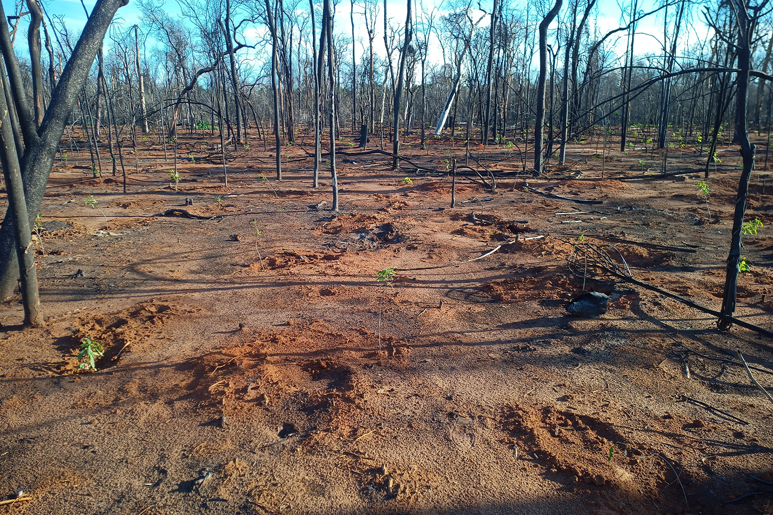
Diamondra Andriambololona: There was in 2013, when we lost 9,000 ha (22,200 acres) of forests and savannas! It was a heavy blow because we hadn’t seen the fire start. Several hours passed before it was detected, which is why there were such significant losses. The reforestation site where Dry Forest is currently working is also part of the area that burned then.
The silver lining was that we’ve never seen as much community involvement as we did that day; there was a real outpouring of solidarity. We mobilized nearly 500 people, including volunteer villagers and members of our fire brigades, to respond to it. We can usually reach intervention sites within one day. That day, I can’t remember how many barrels of water were filled and transported from the springs; there were so many.
We put out the last of that fire after three weeks. In terms of wildlife, there weren’t too many losses to lament because the area that burned was not a core part of the park.


Mongabay: What solution could motivate locals to protect the forest?
Diamondra Andriambololona: The best solution remains raising awareness. For example, we can discourage people from deforesting by developing income-generating activities such as beekeeping, poultry farming, etc.
We can also combine conservation and education in parallel to these income-generating activities. It is important to note that this kind of initiative, like that of Dry Forest, is new in Kirindy Mite [National Park]. The pressures on the forest will continue to increase as long as the people remain poor, so it’s good to give them something that can provide them an income, like saplings of useful trees.
Mongabay: In light of the extreme situation in Kirindy Mite park, are these not hopeless efforts?
Diamondra Andriambololona: I don’t think it’s hopeless so long as a well-established strategy and disincentives are in place. Besides Dry Forest, there are many other active initiatives motivated to change things in Kirindy Mite, such as … USAID [United States Agency for International Development], and the USFS [United States Forest Service].
USAID is striving to transfer the management of the national park to local communities. To do this, the latter are being trained to develop income-generating activities that also benefit conservation. The USFS focuses primarily on reforestation.
Mongabay: Today, what is the foundation of your hope for protecting Kirindy Mite park?
Diamondra Andriambololona: I have hope because we have seen changes; our efforts have borne fruit. As I told you, forest loss is decreasing, and it is currently at 100 ha a year, which is down from five years ago. This decrease has been recorded since 2019.
In addition, there are greater efforts being made to raise awareness among local communities. The number of our patrol officers has also increased: 18 are employed directly by Madagascar National Parks, and 180 are from the local communities. Additionally, as a result of our efforts, our firebreaks protecting the forest now measure 192 kilometers (119 miles) in total.
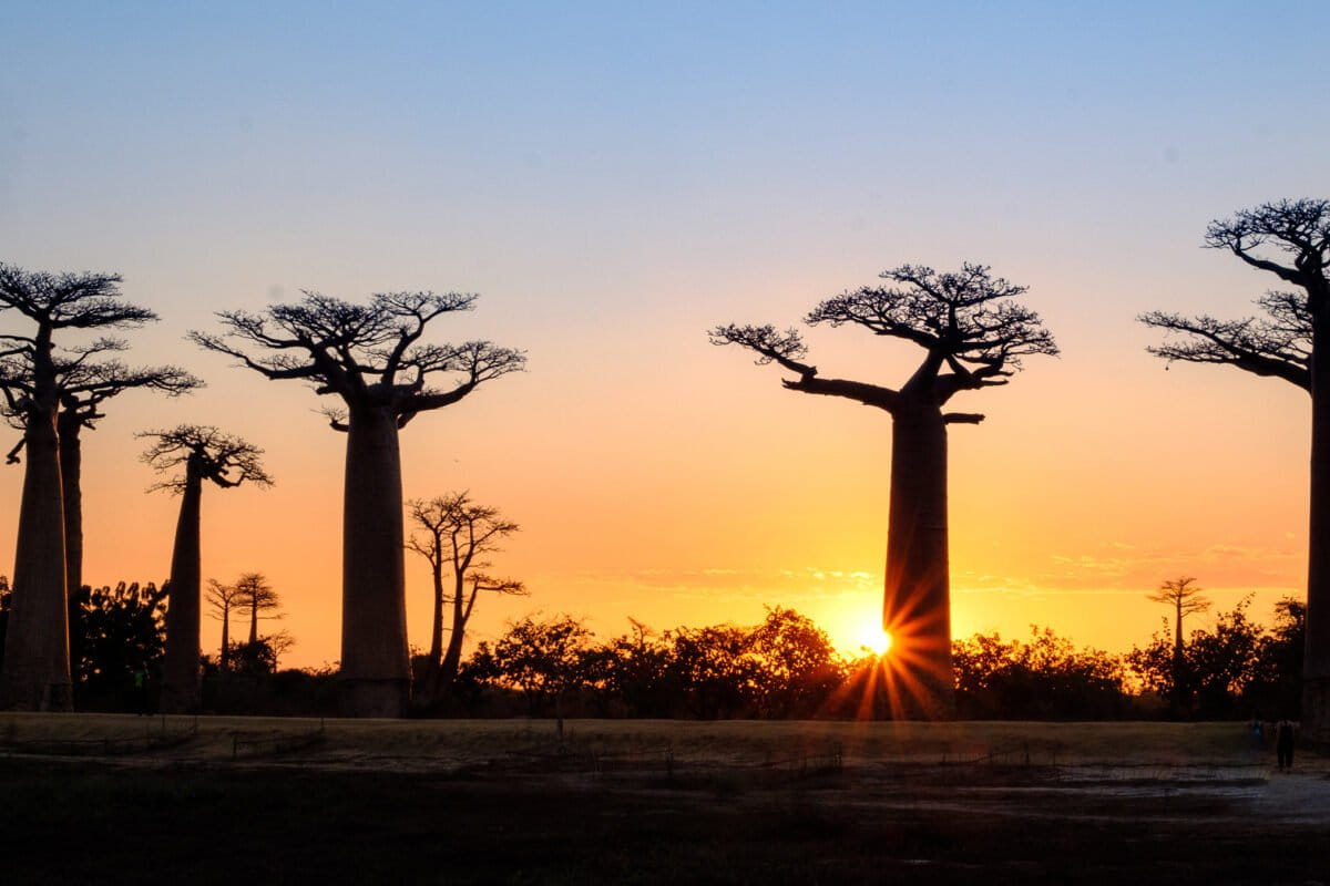
Banner image: Baobabs at sunset in Madagascar. Image by Olaf Zerbock, USAID via Flickr (CC BY-NC 2.0).
This article was first published here on Mongabay’s French website on April 24, 2023.
Extreme reforestation: Baobab planters confront fires, loggers, cattle and more
FEEDBACK: Use this form to send a message to the editor of this post. If you want to post a public comment, you can do that at the bottom of the page.