- Mongabay has begun publishing a new edition of the book, “A Perfect Storm in the Amazon,” in short installments and in three languages: Spanish, English and Portuguese.
- Author Timothy J. Killeen is an academic and expert who, since the 1980s, has studied the rainforests of Brazil and Bolivia, where he lived for more than 35 years.
- Chronicling the efforts of nine Amazonian countries to curb deforestation, this edition provides an overview of the topics most relevant to the conservation of the region’s biodiversity, ecosystem services and Indigenous cultures, as well as a description of the conventional and sustainable development models that are vying for space within the regional economy.
- This is part of chapter 1 of “A Perfect Storm in the Amazon,” see the bottom of this page for links to all of the excerpts.
The Pan Amazon spans approximately 825 million hectares, of which approximately ninety million hectares have been lost to deforestation; this corresponds to ~13% of the original forest cover. At first glance, this percentage value might not seem alarming, particularly in the context of the total extant forest cover.
However, cleared land is embedded within landscape mosaics that include an approximately equivalent area of fragmented forest, both of which are surrounded by extensive areas of degraded forest damaged by illegal logging, wildfire, and overhunting. A conservative estimate of the total area of all these ‘human-modified landscapes’ is approximately 250 million hectares, which represents about thirty per cent of the geographic area of the Pan Amazon.

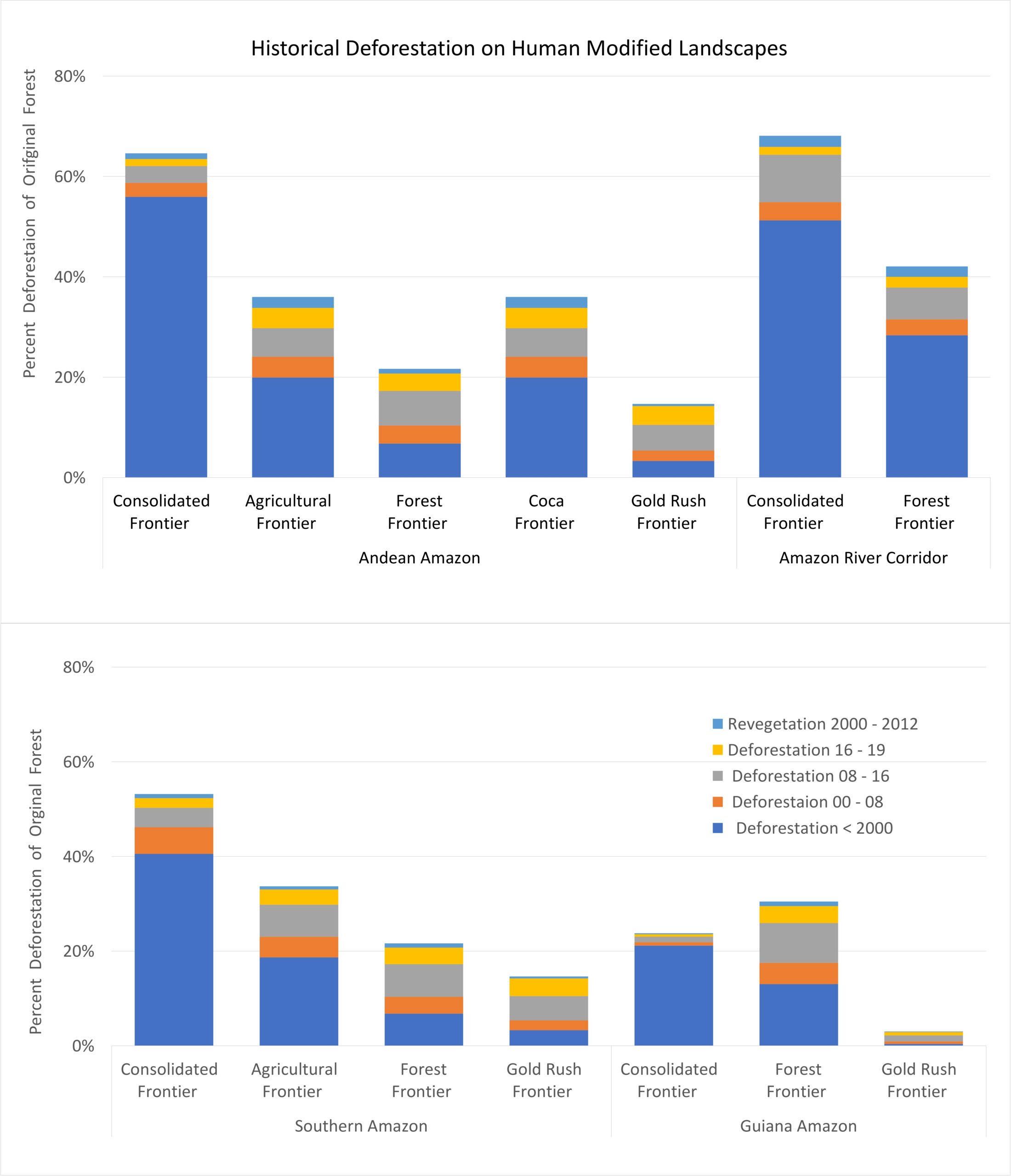
The human-modified landscapes of the Amazon can be stratified into four macro-regions, based on biophysical and cultural attributes that have determined their recent development. Each landscape has a unique development trajectory, but there are identifiable stages that reflect levels of infrastructure investment, agricultural production system, levels of technology, and social capital.

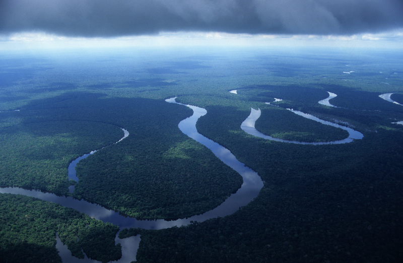
Amazon River corridor
The upland terraces that flank the main stem of the Amazon River are the oldest human-modified landscapes in the Pan Amazon. People have occupied these lands for millennia, but their ethnic composition has changed over time as immigrants and escaped slaves intermarried with Indigenous people to forge unique cultural groups referred to as cabloco (Brazil) or ribereños (Peru). The river connects rural communities with about two dozen small towns and six major urban centers: Belem, Macapá, Santarem, Manaus, Tabatinga, Leticia (Colombia), and Iquitos (Peru). The most densely populated stretch of the river is located between the top of the delta and Manaus, but isolated communities extend upstream to the junction of the Ucayali and Marañon rivers in Eastern Peru.
The foundation of the rural economy is based on the wild fish catch and non-timber forest products, particularly the super-fruit açaí, a palm that dominates floodplain habitats of the lower Amazon. Most families cultivate a garden plot as part of their subsistence economy, while a limited number of secondary roads provide access to forest resources beyond the immediate confines of the river corridor. As a waterway, the river functions as a bulk transport system for bauxite mines located on upland landscapes adjacent to the floodplain, as well as for commodities trans-shipped at ports that service the agricultural industry of the Southern Amazon.
Fluvial transport also serves the oil and gas sector while providing cost-effective transport for timber harvested from remote regions accessed by dozens of tributaries. Manaus is a travel destination marketed as the gateway to the Amazon, while Leticia and Iquitos have developed nature and cultural tourism linked to the domestic and international markets.

The natural habitats of the Amazon River Corridor are remarkably well conserved, particularly above Manaus, where a wilderness riverscape extends more than 2,000 kilometers. Near Manaus, both sides of the river have evolved into forest frontiers, while the upland landscape between Oriximiná and Prainha in northern Pará has been deforested by the small farms and ranches established in the late 1960s and 1970s. Across the river in Santarem, grain silos and port facilities at the terminus of BR-163 are driving the conversion of pasture into cropland, which has caused this landscape in the heart of the Amazon to transition into an agricultural frontier dominated by the cultivation of soy.
Southern Amazon
The national development strategies epitomized by a highway network carved out of forest wilderness in the 1970s and 1980s set in motion a development trajectory that caused this region to be known as the Arc of Deforestation. More than seventy million hectares of tropical forests have been sacrificed to create an agricultural economy that stretches from Eastern Pará, Brazil to Santa Cruz, Bolivia.
Low rates of deforestation within forest frontiers are a function of their remoteness and the poor state of their transportation infrastructure; landscapes closer to markets have transitioned into agricultural or consolidated frontiers. Rapid development has occurred on landscapes deemed to be geopolitically important (Rondônia) or where the soils were particularly apt for field crops (Mato Grosso and Santa Cruz). Public lands have been distributed to more than a million pioneer families and several thousand private companies via a variety of legal and extra-legal mechanisms. The resulting land tenure mosaic reflects both the diversity of landholdings (small, medium, large, and massive), as well as the ongoing appropriation of state lands that continues to drive deforestation on forest frontiers.

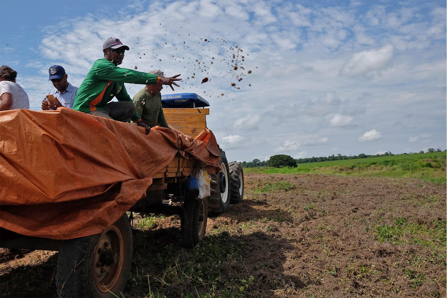
Most smallholders dedicate a portion of their land to produce basic foodstuffs, but the production of beef cattle is the major driver of deforestation on both forest and agricultural frontiers. The global demand for soy in the 1990s stimulated the expansion of agribusiness and enabled business models dependent upon overseas export markets. The cultivation of maize in rotation with soy catalyzed the explosive growth of the poultry and swine sectors, while the cultivation of oil palm diversified the rural economy in Northeast Pará. Global competition is driving investment in bulk transport systems that link the production landscapes of the Southern Amazon to the grain terminals on the Amazon River.
The development strategies of the 1970s included programs for the exploitation of the region’s mineral resources. Its recent history has been marked by chaotic gold rushes that ebb and flow with the price of gold. More long-lasting development has resulted from the exploitation of world-class deposits of industrial metals at the Serra de Carajás in Pará, which stimulated investments in railroads, industrial mills and hydropower facilities. Infrastructure development represents a significant part of the regional economy, in part because the Brazilian government has built more than fifty hydropower facilities in the region, including several mega-scale facilities (> 1,000 MW) on the Madeira, Tocantins and Xingu rivers.
The Southern Amazon can be stratified into five forest frontiers, eight agricultural frontiers, five consolidated frontiers and one active gold-rush frontier. If current trends continue, the forest frontiers will transition into agricultural frontiers and agricultural frontiers into consolidated frontiers. These human-modified landscapes, which are organized around a network of trunk highways, are separated by forest remnants that are increasingly isolated from each other and from the continuous forest landscapes of the West, Central, and Northern Amazon.

Andean Amazon
The cultural traditions and the national development strategies pursued by the Andean republics created human-modified landscapes that are fundamentally different from the Southern Amazon. Each country built a series of individual highways that connect a specific sector of the Andean highlands with an adjacent region of the Amazon lowlands. All roads traverse the Andean foothills, where tens of thousands of settlers established homesteads on steep slopes inappropriate for agriculture. Soil erosion limits the productive capacity of farmsteads while threatening the integrity of the roads built on landscapes with extraordinarily high levels of rainfall.
Colonization has been driven by migration from Indigenous highland communities who have laid claim to small landholdings using forest-fallow production systems to produce basic foodstuffs for domestic markets. Over time, settlers have diversified their production systems to include oil palm, coffee and cacao, some of which is destined for overseas markets. Pastures are abundant, and many families own cattle; however, the beef industry is not a driver of deforestation but an artifact of the forest-fallow production system. On selected landscapes, farmers cultivate coca leaf, sometimes legally for domestic consumption but more often as an illicit crop for the global cocaine market. A limited number of corporations have invested in large-scale oil palm plantations and associated industrial facilities in Peru and Ecuador.
The mineral wealth of the region is concentrated in the High Andes, where global corporations operate industrial mines in polymetallic ore bodies that have been exploited for centuries. Gold that originated from these geological formations has been transported to the alluvial sediments on the piedmont that are exploited by small-scale miners in selected landscapes experiencing a gold rush. The Western Amazon has significant oil and gas reserves located beneath the alluvial landscapes east of the Andes, and the revenues derived from their exploitation have been a pillar of national economies and state budgets since the 1960s.
Investment in infrastructure has accelerated in the last two decades thanks to an international effort to coordinate national development strategies and promote economic integration among countries via the Initiative for the Integration of the Regional Infrastructure of South America (IIRSA). Among the highest IIRSA priorities have been transportation corridors that transect wilderness landscapes, linking the Pacific Coast with the Amazon River and the agricultural landscapes of the Southern Amazon. The massive elevational drop in rivers that originate in the Andes has favored the development of dozens of medium- and large-scale hydropower facilities. With one notable exception, efforts to promote mega-dams have not been successful because the proposed investments have not withstood financial due diligence.
The human-modified landscapes of the Andean Amazon include four forest frontiers and six agricultural frontiers, seven coca frontiers and two gold-rush frontiers. Migration and forest loss occur altitudinally, as agricultural frontiers expand upslope, and laterally, as pioneers settle adjacent valleys or emerge onto nearby lowland landscapes. Unlike the Southern Amazon, where forest frontiers are associated with roads, the most dynamic forest frontiers in the Andes occur along river corridors. Individual lowland landscapes have remained isolated from each other for decades; only Ecuador has built a road that connects all of the lowland settlement zones with an integrated trunk highway. The decision (or delay in deciding) to integrate settlement zones along the piedmont has maintained a limited number of biological corridors that connect the lowland forests of the Western Amazon and the montane forests of the Andean foothills.

Guianan Amazon
The human-modified landscapes of the Guiana Shield have avoided the settlement and colonization phenomena that caused the widespread deforestation in the Southern Amazon and Andean Amazon. Historical settlements are clustered along the coast of Guyana, Suriname and French Guiana, while Venezuela has pursued a national development strategy based on petroleum development and urbanization. Only the Brazilian state of Roraima was the target of resettlement schemes in the 1970s when a paved highway was built to connect Manaus with Boa Vista and, eventually, with the Venezuelan and Guyana national road networks. Currently, Brazil is building a modern highway in Amapá to connect the Amazon port city of Macapá with the development corridor of the Guiana Coast.
Suriname and Guyana were once major producers of bauxite, but those mines have shut down after exhausting the easily exploitable deposits, leaving behind degraded landscapes and toxic tailing ponds. Northern Pará and Amapá have significant reserves of ferrous minerals, copper and gold, but most are located within a strategic mineral reserve that is closed temporarily to exploitation. Venezuela has economically attractive bauxite deposits and world-class reserves of iron ore; nonetheless, its industrial mines and processing facilities are operating at minimal levels due to economic mismanagement.
The very considerable gold resources of the Guianan Amazon are associated with a geological formation known as a greenstone belt that has sustained a decades-long gold rush by small-scale miners, including native-born maroons and temporary migrants from Brazil. Most of the deforestation in the Guianan Amazon is caused by these miners; consequently, it is dispersed across landscapes as small patches that are difficult to detect using commonly available satellite images. Periodic gold rushes have occurred in Bolivar state in Venezuela and along the border with the Brazilian state of Roraima. Large-scale corporate gold mines are operating or under development in Guyana, Suriname, French Guiana, and Amapá.
The human-modified landscapes of the Guiana Shield include two gold-rush frontiers, two forest frontiers and two consolidated frontiers. The recent discovery of large reserves of oil and gas offshore from Guyana and Suriname will transform their economies over the short term.
Hydrological degradation
The Amazon River system is the world’s largest freshwater ecosystem, with nearly twenty per cent of the Earth’s freshwater discharge. It is a megadiverse aquatic biome and an enormously productive ecosystem that provides livelihoods and essential protein resources for its resident populations. It is also a strategic economic asset due to its hydropower capacity and as a waterway in a region that lacks roads. The massive volume of water that flows through the Amazon River system provides an inherent level of resiliency, which is augmented by intact floodplain habitats that buffer seasonal fluctuations in waterflow and absorb the effluents of human society. Nonetheless, development phenomena have impacted the rivers and streams within human-modified landscapes.

Illegal gold mining has impacted the biogeochemistry of the rivers that drain the gold-rush landscapes where small-scale gold miners are active. The spatial footprint from individual mining operations is (relatively) small, but the environmental impact is magnified by the tendency of miners to operate within floodplains. The widespread use of mercury, a heavy metal with well-documented deleterious effects on human health, is creating an environmental legacy that will plague the region for decades. Virtually all small-scale miners violate environmental laws and evade taxes; many are guilty of human rights violations. Illegal gold mining is likely to increase over the near term due to the volatility of financial markets, which motivates global investors to buy gold as a hedge against uncertainty.
Dams and reservoirs cause permanent and long-term impacts by modifying hydraulic regimes, capturing sediment, and interrupting fish migration. Multilateral financial agencies have provided key financing to both public and private entities; companies from China have acquired distressed hydropower assets in Peru and Brazil while providing turn-key solutions to Bolivia and Ecuador. All the Pan Amazon nations have pursued hydropower development as part of their national energy strategies, and Brazil is leveraging the construction of hydropower projects to develop waterways as bulk transport systems.
Land-use change and agricultural runoff have impacted the geochemistry of most of the headwaters of the rivers of the Southern Amazon, where the conversion of ~50% of the original forest cover has increased sediment loads and altered the nutrient status of the region’s unique ‘clear-water’ rivers. These impacts should be mitigated by environmental regulations that obligate landholders to conserve forest in riparian corridors; however, noncompliance is widespread, and efforts to motivate landholders to reforest riparian corridors are constrained by cost and apathy. Deforestation has impacted precipitation regimes, which will decrease runoff volumes, a phenomenon that will become greater over time as farmers adopt irrigation technology to mitigate the threat of seasonal drought.
“A Perfect Storm in the Amazon” is a book by Timothy Killeen and contains the author’s viewpoints and analysis. The second edition was published by The White Horse in 2021, under the terms of a Creative Commons license (CC BY 4.0 license).
Read the other excerpted portions of chapter 1 here:
 Chapter 1. The state of the Amazon
- The state of the Amazon May 31, 2023
- Drivers of environmental degradation in the Amazon June 1, 2023
- The geography of environmental degradation in the Amazon June 7, 2023
- The political economy of the Pan Amazon June 8, 2023
- Understanding the conventional economy of the Pan Amazon June 13, 2023
- The natural history of the Amazon Rainforest June 14, 2023
- Forest ecology and carbon dynamics in the Amazon June 20, 2023
- Climate change and moisture recycling in the Amazon June 22, 2023
- Environmental policy and action on the ground in the Amazon June 27, 2023
- Environmental governance in the Amazon June 28,2023
- The largest land set-aside in history June 29, 2023
- An Indigenous revival in the Pan Amazon July 6,2023
- Monetizing nature: The under-explored power of the Amazon’s natural capital July 7, 2023
- The challenge of the future (and lessons from the recent past) in the Pan Amazon July 12, 2023
- Current policy approaches in the Amazon: certainly necessary, but are they sufficient? July 13, 2023
Citations:
- Boucher, D., P. Elias, C. May-Tobin, K. Lininger, S. Roquemore y E. Saxon. 2011. Root of the Problem: What’s Driving Tropical Deforestation Today? Cambridge, MA: Union of Concerned Scientists.
- IFC – International Finance Corporation. 2012. IFC Performance Standards on Environmental and Social Sustainability. International Finance Corporation, The World Bank Group.
- Busch, J. y K. Ferretti-Gallon. 2017. ‘What drives deforestation and what stops it? A meta-analysis’. Review of Environmental Economics and Policy 11(1): 3–23.
See related news here at Mongabay:
Boosted with fresh donations, Amazon Fund reboots stalled projects